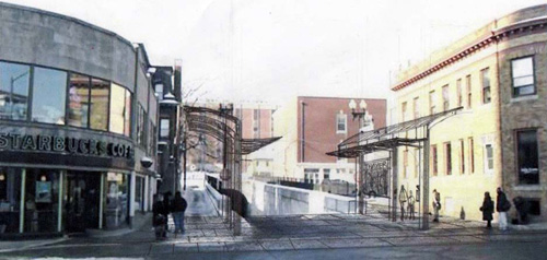
Rendering by Ron Henderson / L+A Landscape Architecture | Click image to enlarge
Reader, Peter Brassard submitted The above rendering of a possible streetcar/bus station at the top of the tunnel on Thayer Street is from the Metro Transit Study.
Read more thoughts about a future College Hill Sub-Hub here and here.
CORRECTION: Peter did not draw this rendering, he saw it the Metro Transit Study. I misread his email when he sent it to me.


Nice look, nice turn of last century look, and it would be nice to have some sort of shelter there, aside from Starbucks.
One challenge to something like this is that Fones alley continues up each side of the tunnel, not sure what access is like from uphill side, but I know that delivery and trash trucks use those bits of sidewalk where the metal work is inserted to access the alley in order to service Starbucks and Fones Alley Pub.
The drawing is by Ron Henderson / L+A Landscape Architecture, who was urban design consultants on the Metro Transit Improvement Study. There are other options which included full spans across the mouth of the tunnel and a center post scheme, among others.
The delivery trucks on Fones Alley require a clearance that is so high that it offers little for climatic protection for those waiting for the bus or trolley. RIPTA pulled the plug on further development in the middle of the study – as they did at the end of the study on the design conclusions from the Kennedy Plaza Workshop.
All planning. No design.
The study also had a lot of cut and paste from the Transit 2020 Report.
In support of the previous commenter, it should be noted that the above referenced concept sketch (a sketch, and not what would normally be construed as a rendering) for a possible College Hill Transit Hub (not a station, per se) appears in a small format in Appendix D (page 8 of 21) of the Metro Transit Study, and is accompanied by the following text:
“West Side Transit Hub
At RIPTA’s request, a dedicated bus lane for berths was recently constructed on Cahir Street, between Westminster and Broad, as part of a RIDOT-funded project. RIPTA now proposes to add passenger amenities at this location, which is just west of I-95 and adjacent to three Providence high schools. These amenities would be consistent with the concept established for Local Activity Centers under Project #4. Bus Stop Improvement Program, including bus shelters, map and schedule information, bike racks and potential fare vending at a nearby location. Real-time bus arrival information would be displayed as part of RIPTA’s Intelligent Transportation System (ITS) project. Finally, unique design elements would be considered as part of hub design, incorporating new RIPTA branding elements and public art, and reflecting the character of the adjacent neighborhood.
College Hill Transit Hub
The concept for College Hill includes the installation of bus shelters (or a canopy over the top of the bus tunnel) at Thayer Street to provide a sense of place and conveniences for waiting passengers. Amenities would be the same as listed above for the West Side location.”
I believe the key phrase is: “…bus shelters (or a canopy over the top of the bus tunnel) …” This allows for a wide range of possible physical designs, and supports the contention that, despite the concept sketch shown, there is no design for this location at present.
I would, however, disagree with the previous commenter about “a lot of cut and paste from the Transit 2020 Report.” I’m not sure what “a lot” is, but I am guessing there can’t be “a lot” cut and pasted from 21 pages of Transit 2020 report text (minus the meeting minutes) in the more than 200 pages of reports and supporting documents generated by the Metro Transit Study that are available on the project web page.
That being said, I remain very interested in the suggestions presented in this series of GC:PVD postings. Thanks, and keep up the good work.
I want to retract the part of my earlier post where I said “The study also had a lot of cut and paste from the Transit 2020 Report.”