A couple weeks ago we linked to an article in the ProJo about a proposal to build a medical facility at Pat Conley’s Providence Piers. Today, PBN has a more fleshed out account of that plan.
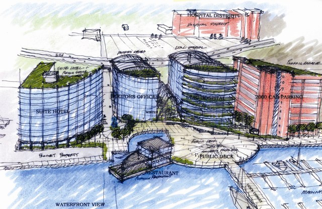
Rhode Island Medical Arts proposes to build a $350-400 million development to include an acute care center with 250 beds, a hotel, a marina, a floating restaurant, retail, offices, a parking garage, and public walkways.
Currently of course, the area is not zoned for most of these uses. The City Council Ordinance Committee is hearing testimony on changing that however.
What do I think about all this? Well, as I said before, I rather think the uses proposed here would be better suited on land closer to the hospitals or in the Jewelry District. Certainly it would be advantageous to have a hotel in the Hospital District so that loved ones could stay close-by to the hospitals. We have a vast amount of land available for development elsewhere.
That said, I don’t outright oppose these proposed uses in this area either. I think we can find a way to balance the industrial activity currently found on Allens Avenue with other economic development.
Aside from the zoning question, the site also needs environmental remediation. It sounds like the developers are waiting on the state to get that done. Zoning changes, environmental clean-up, funding in this economy… I won’t be holding my breath waiting for the groundbreaking to happen here anytime soon.
[alert type=”muted”]Related:
Put the Waterfront to Work (Providence Planning Department)
Providence Working Waterfront Alliance
Redevelopment Agency May Buy Providence Piers (Greater City Providence)[/alert]


This wouldn’t be the worst thing to happen, since Conley’s loans are deeply underwater, which could leave the site embroiled in lawsuits and undevelopable, even unusable for a decade or more. The environmental cleanup might be simpler than it appears. Jersey City’s Harborside District was similarly contaminated. Most of its sites were capped and sealed, even for residential developments. Locally the historic tax credit made cleanups possible for toxic sites that had languished for decades.
Expect more far flung proposals away from the planned new downtown district. Master plan initiatives rarely stay the same or have the anticipated effect. Capital Center was meant to be simply an office park. Even though it still has several undeveloped parcels, it’s become a much more diverse mixed-use neighborhood, which is better for the city.
In the current economic environment, if they have the money or borrowing ability, let them build it. Even if the development is phased, a project of this size along with the Brown’s medical school could catapult this new industry radically shifting the city’s economy. Downtown is expanding and new development will be uneven with a lot of holes in between for a while.
Too Far from the hospital district? According to Google Maps walking directions from 146 Allens (the frontage address of Conley’s property) to 2 Dudley is 3/10’s of mile and should take about 6 minutes. The same distance as walking from the Hilton to Atwells and Dean on Federal Hill. Granted the scenery is a little more pretty. But, considering how we are always discussing getting out of our cars (which i agree with) I don’t think that walk is too much to ask. If you needed to just put a “green” shuttle service between the two.
As for the design. I am not sure i would put the hotel up against Pomfret Marine. How about putting the Parking garage on the southern end and pushing the other buildings to the north with a way to move from the garage to the hotel to the hospital similar to the way you can get from the Dunk to the Westin (thinking about those cold winter winds). Not sure how the proposal will fly but it still beats condo’s and gives the hospital district room to expand without filling in the Jewerly District.
Not gonna fly. At least its not gonna look like that or be that beautiful unfortunately. But still, sick design…
Did anyone else go to the Waterfront Planning session (probably two years ago, now) where this sort of thing was held up as exactly what NOT to do? This looks exactly like Toronto: a wall of skyscrapers cutting off the waterfront from everything else, with only a single restaurant to energize the public space. I’m no city planner, but I think this would be a disaster.
The city should do it’s own study regarding how many jobs exactly exist in the industrial area. I doubt it’s even half what the “Working Waterfront” group claims. All I see is old, rotting dry-docked boats, crumbling buildings, and polluted.
It’s time for Providence to move on. We are not going to be a manufacturing port anymore. It’s time to rev up another industry. This site would be a good start to get some medical and tourism economic engines started.
only parking for 2000 cars!?!?! they need to make that 10,000 spaces and 15 stories of parking!!!!!
– – –
why cant they spread the parking out amongst all the buildings (in the basement) instead of building a gigantic parking structure?
Below grade parking is a nice idea, but won’t work here because of the flood zone. Imagine waves splashing over the lobby desk and crashing through the front doors during a good storm. Perhaps that’s why they proposed a floating restaurant, besides the gimmick value.
A separate parking structure could be the better solution, since it would allow the buildings that people inhabit to be connected to the ground, like a traditional city. A building perched on top of a garage structure is often awkward and disconnected to the street and less human in scale. Also, a garage plinth assumes that in the future parking will always have to be provided. In a fifty or a hundred years it may not. If a garage building is designed with level floors and speed ramps off to one side, it would be possible to repurpose the structure for a habitable use in the future.
In the developers very rough sketches they are showing something like 10 story buildings, but on this site what views will be blocked? On the west side of Allens Avenue there’s a small lot used as surface parking, which is set in front of a backdrop of a two to three story high freeway embankment. On the west side of 95 currently there’s a low rise manufacturing zone and a 3-decker neighborhood on a hill roughly 70 feet above sea level. If the two last 3-deckers closest to 95 have a water view; it’s panoramic. They would see more than just high-rise buildings at the Conley Wharf site|they would see the entire waterfront to the south to the LNG tank. The high-rise buildings would simply be part of the overall composition of the view.
Providence has been stuck on the notion that buildings along the water must be low and buildings further away are allowed to be taller. This is not the only way to plan or develop a waterfront and is not necessarily the best or even desirable way to do it. If there’s a 6-story building on the water and a 10-story building behind it, how many people get a water view and what is the quality of that view?
No one wants to see Providence turned into North Miami Beach. There are other examples of how to design high-rise waterfronts. The current statewide regulations for waterfront development in New Jersey require that all waterfront high-rises be situate the widest part of a tower perpendicular to the water’s edge to minimize the impact on upland views and to create framed water views between towers. All waterfront buildings have to be approved by the state’s environmental protection agency. The newer parts of Vancouver utilize point towers that have smaller more square footprints that achieve a similar effect.
The view corridor which must be maintained is that of Public Street. When you walk or drive the view should be of the river, not a building blocking it. The proposed hotel is located closer to the river beyond the historic building and to the north is the proposed office building. The developer should be asked to setback the hotel and office building 10 feet away from the Public Street view corridor to better open and frame the view from the street.
Peter, as I understand it, the view issue is only minimally important. The reason for the smaller class of buildings between waterfront and skyscrapers is to increase and vary usage and to create a permeable, inviting border. The current design (I believe) creates an isolated waterfront that would only be used by hospital patients, staff, and visitors, with some few additions if the restaurant were particularly popular.
Jesse, I agree that the view is not the whole issue. Ground level activation needs to be part of the formula. From street level a 4-story building is no more permeable than a tower and the effects between the two are not really different. As long as the ground level is activated and pedestrian realm is designed to a high standard.
If there were ground floor retail, besides building lobby entrances and a restaurant, low 4- or 5-story buildings couldn’t possible provide the population to support and keep viable an assortment of wide retail establishments. Not every city development can be a major shopping destination. A larger hotel and larger office building, along with the hospital visitors, a marina and the occasional docking of cruise ships could offer more opportunities for retail.
The developer’s scheme is only a preliminary diagram that requires a significant amount of work to make a design. What they are suggesting is a generous public open space along the water, a marina and some idea for an enclosed or partly enclosed arcade between two of the buildings. The arcade would require active uses as would the pedestrian access to and from Public Street. Ground activity might be less along Allens Avenue, although ground floor uses could wrap around from the arcade and the Public Street corridor onto the avenue.
It would be unreasonable to assume that all faces of a development have to be equal. The area to the north along Allens Avenue has a freeway embankment forming the street wall and on the opposite side is industrial with sand piles and oil tanks. If non-industrial development were to take place to the north in the future a waterfront corridor culminating at Public Street rather than the avenue would provide a more engaging pedestrian experience. Public Street, the major east-west street and the separation between buildings offer the permeability. The distances between buildings are not fixed and require review, no to mention building setbacks along streets.
Possitive feeling about this project.Yes,move the garage south and juxaposed,only to give the north structures prominence from the northbound approaches .And please give these buildings transparency. I’m thinking of theBCBS as a model.
I have to agree with others that this is really not a bad idea in theory.
Medically, the whole region needs long term care beds and the institutions and the names from the Boston area thrown around in the original proposal are real, established players. This is actually VERY close to Rhode Island Hospital and, for all practical purposes, very centrally located for the region. The waterfront location will be a great selling point and, quite frankly…
What else could really go there? I mean, really? The original condo/hotel/restaurant/gallery/etc proposal was pure fantasy. Why would anyone go to that spot? It has no real views, no real atmosphere, no real attractions…
Offices close to the medical district and a long term care hospital on a site that will require some environmental work is a great idea in my mind… The working waterfront folks shouldn’t have a huge objection since this actually adds jobs to the district and the residents and workers there won’t have nearly the quality of life concerns that, say, condo dwellers will.
Design-wise, this appears quite poor… I absolutely agree with everyone that the garage should be on the South… Why would they want to deprive the office building/hotel/hospital of a skyline/bridge view looking North? I also think they could bring back their brick motif from the original design and ditch the glass.
The idea of public space there is, while nice, quite symbolic only… What would people go there for who don’t work there? The only thing I could think of would be marinas, boat launches, kayak rental, etc…
Dan,
When I was thinking too far, I was thinking of the hotel functioning as a hotel for the hospitals (although that is not necessarily what it is proposed to do). I’m thinking of parents with a sick kid at Hasbro, who would likely be leaving a bedside of a sick kid and wanting to crawl into a bed as nearby as possible, having the hotel right in the hospital district makes more sense to me. Boston Children’s has a Best Western right across the street for example.
Although even though the distance here is totally walkable, I can’t imagine the average person wanting to do it (I can’t imagine myself wanting to do it). The Eddy and Public Street corridors have to be developed to become walkable environments. Currently it is basically all surface parking between the hospitals and here along Eddy and Public and the environment under the highway is bad. I imagine though, if this project were to move forward, the hospital shuttle system would be expanded to include it.
I agree with Peter about Public Street acting as a finger of development to the waterfront. Really, I never see Allens Avenue being developed into any kind of walkable functional urban space as a whole. Rather I see the urbanity reaching down to it from Eddy Street. I’ve always seen this parcel as really the most developable, because of Public Street. Oxford Street could provide another finger.
The parking garage blocking the views toward downtown may seem shortsighted but it does shield the development from Sprague, which isn’t going anywhere. Also, if the main entrance to the development, and the main way to reach the water is Public Street, then swapping the hotel and garage location would mean that one side of that Public Street space would be dominated by the garage. The garage could be animated with retail on the ground floor, but the lifeless hulk would still loom over the space, the hotel would be lit at night and would be a better wall for the public access corridor.
I’m curious to see how the Allens Avenue side would be treated, but the really important part is developing Public Street to connect this development to other developed parts of the city.
I agree with Jef regarding the garage. Public Street would be diminished by such a structure. The existing historic building would also suffer being behind a “waterfront garage.” Perhaps a landscaped drop-off plaza could be situated between the proposed hotel and old building and utilized by both.
At this point it’s irrelevant whether the buildings are clad in glass or brick or something else. Until there is an assurance that the zoning will be changed to permit this development, the developers will not make a serious commitment to assemble an architectural and engineering team to design the project.
This proposal is an extraordinary opportunity for the city. The $350 to $400 million to be spent on a project that would create 2,000 permanent jobs would in effect be a gift to the city. The temporary construction jobs that would be generated would not be insignificant. The added benefit of the hundreds of other people like hotel guests and daily hospital visitors that would visit the development would infuse the waterfront with a dynamic positive energy that it lacks today. The restaurant, marina, and cruise ship dockings would add another dimension making this area truly mix-use district. This project would transform what’s currently marginal part of the city into something spectacular.
Looking at the general trend of comments at this point, the first thing that comes to mind is that we’re so desperate for development, any development (or perhaps been beaten down by so much bad design) that the first semi-serious proposal acquires an undeserved inevitability.
Bret writes: “What else could really go there? I mean, really?…Why would anyone go to that spot? It has no real views, no real atmosphere, no real attractions.”
Is this really a serious question? Isn’t the story of any major urban planning success, anywhere, the story of taking a place with no views, atmosphere, or attractions, and adding something that suddenly makes it worthwhile?
Somewhere between the current failure of imagination and insert-the-name-of-your-mixed-use-utopia-here, there are very viable alternatives.
Jesse, The Conley site presently has a pier and a beautifully restored historic building, which are dominated by a surface parking lot. The proposed development may indeed not be a utopia, but it’s a decent preliminary proposal that meets many economic and planning objectives that the city and state have been studying for the last several years. What’s your urban design concept for this site? What viable alternatives are you suggesting?
For alternatives, Peter, just look at the two issues I’ve already identified, permeability of the border and use.
What’s the best way to create a more permeable border? I have no idea, but maybe urban planners would move buildings back from the water, create more and smaller buildings, set buildings back from the street, add more uses for the area, or a thousand other things.
What are the best additional uses? I have no idea, but pick one and I’m for it — health care plus entertainment, health care plus commercial, health care plus residential. Any of them improves upon a monochrome.
ProJo article about the zoning hearing.
Jesse:
The drawing above is far from a final proposal, imagining that the needed zoning changes go through, and this development is real, not some vaporscraper like we’ve seen so much of, there is plenty of design review that will take place.
My biggest nit with this drawing is that I would like to see the space between the hotel and office be larger (slightly). Make the Public Street right of way wider. I don’t see though what pulling the buildings further from the water would accomplish. It appears to already have a substantial amount of space. The activity here I don’t think will be vast, no major festivals or such, that is best left to India Point, the new park under 195, Station Park, the Skating Center… The area should fill when cruise ships come through but otherwise be lightly used mostly by hotel guests, hospital visitors, and people visiting the restaurant and using the retail.
I think there is a balance between a generous space, a degree of intimacy in a space, and a space being too large. I’d err on the side of creating a sense of intimacy over have a large little used space just for the sake of having a large space.
It also appears to propose an atrium type space between the medical office building and hospital. I can understand the desire for this at a waterfront location in a cold climate city such as Providence. But these atrium spaces have a tendency to become privatized over time. I would prefer not to see a space like that unless their was ironclad buy in from the develop that the space would remain public.
I would also like to see the city start getting more out of developers. This has been discussed in the Comp Plan process, incentive bonuses, doing something above and beyond and the developer gets a bonus. I’d like the city to get the developer here to rebuild Allens Ave., creating a strong pedestrian walk way along Allens Avenue to Collier Point. At Sprague, the activity won’t allow a public waterfront walkway, so pedestrian connections between this site and Collier Point Park will have to be along Allens Ave. So have the developer pay to really make that walkway shine. Build a wall or other screen to block Sprague from the street, plant trees, public art, create a wide promenade… The developer should also find a creative way to improve the pedestrian environment on Public Street under the highway and be tasked with maintaining that space. Not sure what I would trade to the developer as bonuses for these items, but they are worthy gets.
It seems to me, the proposal has a good number of uses already, offices, medical care, cruise ship terminal, hotel, retail, restaurant. I don’t know how much more mixed use it can get beyond adding residences, which is not proposed as a zoning change at this point.
Well, you all know I’m all about transit. I’ll wait to see more firm renders to judge the look, but I’d like to see them partially fund the needed improvements (stops, platforms, canopies, etc.) to support the trolley line that will connect the Hospital District to KP. Even if this needs to be sort of a spur or a loop to what is currently planned by RIDOT/RIPTA. Street improvements too. If they can borrow 400M for this project, they can include a million for transit improvements.
ProJo has a story today about this project. Focused on the criminal history of one of the developers, but what I found far more interesting was this:
A monorail!? Uhm, that would be cool actually.
Agreed!
All i think of now when someone says monorail is that Simson’s episode that is a take off on Music Man.
Me too!
No kool-aid for me, please.
Waterfront Garage? What is this, 1959?
Act now and we’ll throw in a nifty monorail! Yeah right.
Walkable streets need to be filled in between downtown and the hospital and adjacent to the hospital. There is a lot of urban fabric to be knitted before some scrawny finger of it is going to reach down Public Street to Allens Ave.
The same number of people are going to walk there as ever walked to the pier, the special events there, or the ferry when it ran from there. This development will be an automobile dependent island for a long long time, period.
I haven’t lost any of my cynicism in the move south so, putting aside for just a moment all the crazy back story and the criminals involved–does anyone actually believe that anyone in the region has this kind of money for development?
Perhaps I had just seen too many of these grand design schemes, only to have the developer come back with hat in hands crying poverty, and then the rezoning has happened, and the crappy part of the project built, and all the cool pieces gone up in smoke.
This is why, again, putting aside all the chatter, we need things like performance bonds to ensure that what the city is promised, is what the city gets, and nothing short of that. This is a perfect example of why that kind of legislation should be put into place before any permits are pulled, before a master plan is heard.
Besides the cool factor, they must have proposed a monorail because the operating expenses would be much less than extending a streetcar line; no operator salaries, plus a single monorail and one car. The single car could go back and forth between the waterfront and the hospitals 24 hours. Maintenance and electricity would be the only major costs following construction.
A monorail might be worth considering instead of the proposed Downtown streetcar. The upfront costs would be greater with a concrete monorail structure along with station platforms with glass enclosure and sliding doors, elevators, and stairs, but there would be no train operator salaries.
In Las Vegas the line is completely unmanned with no train operators or booth attendants. Many airports also use unmanned monorails or trains to move people between terminals. Since the federal government will pick most of the costs for construction and won’t cover operating expenses, it might work for Providence, especially with an underfunded RIPTA and its annual financial crisis.
Andrew has a point about the waterfront garage. The developer could buy the parking lot across Allen’s Avenue and put a garage for the development there. That could allow for more open space between the three new proposed buildings or offer an opportunity to leave the historic building with an unobstructed water view, by locating the new buildings north of Public Street.
PBN: New zoning rules for Allens Avenue to reach Providence City Council Thursday
PBN: Providence Piers owner files for bankruptcy, avoids foreclosure
SUPRISE! This project isn’t happening.
Providence Business News: NatGrid buys Conley’s Pier