This post was submitted Greater City: Providence reader Peter Brassard. If you’ve written something you’d like us to consider posting, please contact us and let us know.
Providence’s Core Connector transit system should be based on its ability to interconnect the city’s Occupation Districts and cultural venues, not just to Downtown and parts of the East Side and South Providence. If the goal is to reduce automotive dependency and produce the greatest number of jobs, attract real estate and economic development, all of the city’s Occupation Districts must be interconnected with a high-frequency transit system. Occupation Districts are employment centers where most educational, institutional, industrial, or business activities are situated. Besides serving employment centers, the Core Connector should provide access to major cultural and public event venues and recreation destinations to accommodate the public and to reinforce tourism.
Service schedules should be high frequency and ideally operate 24 hours, 7 days per week as students, hospital staff, and service workers often travel beyond midnight. The Core Connector should be operational well after the closing hours of bars and other entertainment venues to help reduce alcohol related car accidents. Schedule headway times should be at short intervals for reliable convenient service and to facilitate fast transfers between routes.
If the priority is interconnecting the city’s economic centers, residential neighborhood connections should be considered secondary. If a line passes through a residential area, the neighborhood can be directly served. People can plan in advance to leave or return home with transit that may have longer headway times. They can use existing bus lines to access the Core Connector to get to jobs or schools. Alternately, a series of new “feeder” bus routes or Rapid Bus could be developed to bring residential passengers to the Core Connector.

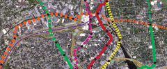
Click image to enlarge
The Occupation Districts diagram analyzes locations and potential maximum densities for Occupation Districts, as well as, showing an overlay of possible citywide routes. Providence regulates land use mostly with height limits, lot coverage, or dwelling unit maximums. Real estate development is generally calculated by potential developable floor area.
A scale of Floor Area Ratio (FAR) is assumed based on permitted number of floors combined with permitted lot coverage maximums to create the diagram. Occupation Districts are differentiated by a color that corresponds to a maximum FAR range or use type.
Example of FAR: a 10,000 square foot lot with an existing single-story 5,000 square foot building would equal 0.5 FAR. If the site were built to a maximum 7.0 FAR, a 70,000 square foot 7-story building could be built. Offices or laboratories would more likely be interested in developing this mid-rise building type.
Institutional Districts, which usually have high numbers of employees and/or students, are identified in purple. The city’s largest high schools are added to this group. The greatest potential to build new Occupation District floor area is within the Downtown medium- and high-density areas identified in orange and yellow respectively, and in medium density manufacturing and waterfront districts identified in red. Johnson and Wales’ Downtown Institutional District also has a potential for high-density development. Low-density Downtown, waterfront, and commercial areas are identified as blue. Residential areas have not been analyzed. The proposed “Knowledge District” rezoning area is shown only with existing underlying FAR and three primary neighborhood restaurant/retail destinations are highlighted.
Manufacturing and Waterfront districts represent the highest percentage of land area of all Occupation Districts and have a great potential to develop new employment areas. These districts are typically under-built as permitted by zoning. Besides historic mills, many properties are vacant or parking lots, or have single-story structures on a fraction of their lot area. These zones often allow for mid-rise buildings of six to seven stories.
The transit routes on the diagram show a system roughly 38 miles in total length separated into seven individual routes or lines. Most Occupation Districts and the zoo are a short walk from a Core Connector stop. Three lines go directly through Downtown while two others skirt its perimeter. Four lines pass directly by or near the train station. One line would utilize the now abandoned East Side rail tunnel and for this example the existing bus/trolley tunnel was not used for any routes.
A few lines extend and terminate in residential neighborhoods with minor Occupation District destinations. This allows for all parts of the city to be no more than a 12 to 15 minute walk from a Core Connector stop, though most city locations would be less than 10 minutes away from a stop. Every neighborhood would have direct access to the Core Connector’s enhanced transit service. Operations during off hours could provide service when the traditional buses are not available, even if it might be a longer walk for people to reach their destination from a Core Connector stop.
With the exception of most of the East Side, Providence has a radial street plan similar to European cities, which is less typical of most American city street grids. The route layout attempts limit the impact of the radial streets to offer more route options and reduce the necessity for all transit trips to go through the CBD center. Also transfers are shifted to the edge of the CBD to allow for better connections to sub-hubs.
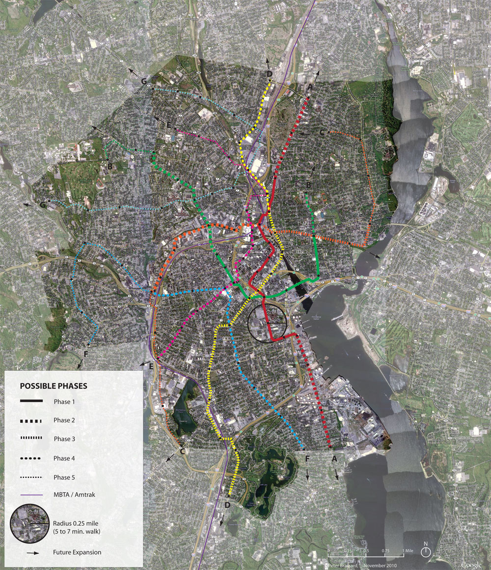
In this example, it is assumed portions of the “A” and “B” lines would be part of the first phase of the Core Connector. The “A” line would start at University Heights, then meander through Downtown connecting the train station and Exchange Street to Weybosset and Broad Streets to Franklin Street in the Jewelry District, and then to Plain Street and the hospitals, and to the Allens Avenue waterfront. The “B” line partly loops around Downtown starting near Thayer Street, extending south to Wickenden crossing west to Point Street, where it would intersect the “A” line then extend north along the Stewart/Cahir/Dean Street corridor to Atwells Avenue.
The advantage of these alignments is that Downtown would be connected with its adjacent neighborhoods and transit sub-hubs in the first phase of the transit project. The proposed Franklin Square sub-hub would either need to be relocated or the route adjusted for a direct connection with this example. Three major neighborhood restaurant districts plus food shopping destinations would be interconnected during the system’s first phase. This would help considerably to reduce car trips. There are two proposed stops at perimeter locations of Kennedy Plaza. This would leave the central portion of the plaza unencumbered by transit vehicular movement to allow for more flexibility with the proposed redesign of the plaza for active pedestrian use.
The example routes could be used for any transit mode, though for streetcar or rapid bus, alignments on Weybosset Street in the Financial District and Friendship Street in South Providence might be limited to a single track, or right-of-way due to the narrow street width. Since beam assemblies would be elevated, light-monorail alignments could easily be shifted to alternate streets in neighborhoods on opposite sides of highways and the river, which is what the example illustrates.
Click image to enlarge
The Phasing Diagram shows a six mile long first phase, which is longer than the current official proposal. Also indicated is a ¼-mile radius circle that represents the typical distance of a five to seven minute walk from a Core Connector stop. Most of the example system would have the ability to be extended to adjacent cities and towns. The purpose of this route example was to interconnect the maximum number of Occupation Districts within the city. Other alignments or combinations of routes could be developed other than what’s shown in this example. Providence’s Core Connector transit system should be planned to encourage real estate and economic development. Any system should place Providence on an equal footing and competitive with other cities and metropolitan regions that are making a commitment to rail transit systems.


Glad some one is thinking big!
Route B is an excellent idea. The college hill – jewelry district (how I hope that “knowledge district” does not catch on) traffic that they seem fixated on to patronize the downtown route will actually be better served by route B.
Also glad to see that “Restaurant districts plus food shopping destinations” are not neglected. People plan their days and travels around meals. The food destinations must not be only special occasion restaurants and gourmet shops. If good cheap places to pick up fresh food to cook at home or brown bag are out of reach without a car, people will continue to plan their days around driving.
Right now, the B line would be a dream for me. It brings me almost literally door-to-door home to work. I’d also really like a way to get to the East Side without having to go through Downcity. If I don’t need to be Downcity, then the trip through it eats up a lot of travel time. And, I have friends at the northern end of the B line and short of making the Dean Street viaduct pedestrian friendly, having a transit line go over it would be marvelous. It would also allow me to go grocery shopping at Aldi on Smith Street which, without a car, is pretty much impossible now.
Any transit link like this is going to be extremely dependent on headways (the amount of time between trains). The current proposed Core Connector, or Peter’s A line, would be of limited use to me because I can walk pretty much anywhere downtown within 10 minutes (the extremes of the line, Brown and the Hospitals I rarely go to).
The Core Connector of course is not all about me (why it is not, I don’t understand), but I’m imagining there could be a large demand for short intra-Downtown trips, within Downcity and/or the Jewelry District. If I can walk where I’m going in the amount of time I would be waiting for the train (then I have to pay for the train too), then I’m a lot less likely to use the train. Anything more than 7 minute headways will be a problem for the service I think.
I’d like to see a streetcar that runs from the Pawtucket line to Public Street in a oblongish, meandering loop that touches the college area, india point/warterfront, jewelry district/RI hospital, downtown and back. It could run right down the middle of North Main Street (like the St. Charles Avenue streetcar in New Orleans). The abandoned stretch that used to house Sears, the Golds Gym, and the little bowling alley provides ample space for a business/parking hub (perhaps another Rhode Island Auditorium?) Think about it. The Auditorium stop serves as the line’s northern anchor. Add some landscaping and cool shelter stops along the way with artsy trash cans and in no time you’ll have reawakened a 2 1/2 mile stretch of the city that’s been dormant and depressed for decades and turned it into a quasi-pedestrian neighborhood that automatically adds another dimension to the City’s revitalization plans.