The city and RIPTA have identified the West Route as the preferred Core Connector (aka Streetcar) route after public meetings and consultations with neighborhood groups and area businesses and institutions.

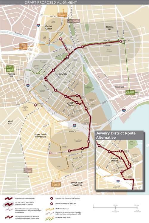
Larger image [.pdf (688 KB)]
A potential new transit route through Providence’s downtown core has been identified, connecting the Hospital District in Upper South Providence with Downtown and College Hill. Both streetcar and enhanced bus transit are now being studied as future modes of service along this route.
This milestone in the Core Connector study was achieved by evaluating a range of possible paths for their ability to meet project goals and key performance measures (see summary here). Members of the public were able to weigh in at a December Public Forum and at more than a dozen meetings with businesses, institutions and neighborhood groups along the corridor. Information continues to be gathered along three segments of this route:
- Along Dudley Street in Upper South Providence, where new streetcar or bus service could terminate in the vicinity of Women & Infant’s Hospital or closer to Prairie Avenue.
- Through the Jewelry District, where more engineering review is needed to identify the best way to traverse the narrow streets of this emerging Knowledge District.
- Between Kennedy Plaza and the Train Station, where a mix of modes will be considered to determine the best means of connecting rail passengers and others living, working and shopping in Capital Center.
After an initial screening process to compare the benefits and costs of three route options and hearing feedback from the public, the Technical Working Group, key institutions, and stakeholder groups, RIPTA and the City feel that the West Route is the best option for Core Connector service. This route will now undergo further analysis.
Why was this route selected?
This route was selected out of three route options that were initially studied because it:
- Serves the most attractions, activity centers, existing businesses, cultural destinations, and neighborhoods while promoting future development
- Serves the most redevelopable/currently vacant land (nearly 50 acres of vacant or underutilized land sits ready for development within the study area of Downcity, Capital Center, the Jewelry District, and the Hospital District)
- Is the most intuitive of all the route options, providing an easily understood transit service for residents, workers, and visitors to the area
- Provides the best options for future extensions west of Downtown
- Provides the best opportunity for the development of a Downtown transit corridor on Washington and Empire streets and the best connections to RIPTA’s planned Rapid Bus route
- Has the fewest potential environmental impacts for hazardous materials and historic properties
Key Advantages
- Relatively narrow streets, on-street parking, and close buildings encourage pedestrian activity and relatively low automobile speeds. This type of street is conducive to the pedestrian orientation of a transit circulator.
- Provides the best opportunity to develop a downtown transit corridor along Washington and Empire streets, integrating with both Rapid Bus and local bus service
- Serves the most activity centers by reaching the western half of Downcity
- Provides a logical connection for extensions to the West End at the intersection of Washington and Empire streets
- Provides the most intuitive route, enhancing the passenger friendliness of the route
Key Disadvantages
- A slightly longer travel path through the western part of Downcity may require slightly more infrastructure and may add one to two minutes to transit service between College Hill and Upper South Providence


Fully behind this one. I like the plan a lot.
Ok, this one isn’t bad. Now lets see if they can secure the financing and begin construction sometime in Q4 of this year. That would be nice to see.
This is a great plan. However, I think they need to use the alternate Jewelry District plan, putting it closer to the Children’s Museum, and the Brown medical buildings on Point St. I also think they should just go ahead and extend it to Prairie Ave. While there aren’t any “destinations” there, there is a large population of people within the quarter mile walk, and it puts it closer to the proposed rapid bud route down Broad St. Finally, it really should connect to the train station. I almost feel it’d be pointless if it didn’t.
What’s happening on Chestnut St? Right now, that’s a one-way street, particularly between Pine and Weybosset. But the map makes it look like it will be two-way with the streetcar.
I assume it will become two-way without parking on most of the street. Empire Street is also slated to become a two-way street so Empire/Chestnut will be a continuous two-way street across town.
RIDOT’s plan for rebuilding the grid calls for a two-way Chestnut Street, at least from Clifford to Pine Street. See page three of this .pdf.
The section between Pine and Broad/Weybosset is not part of the Iway scope of work, but with Empire becoming two-way, it only makes sense for that block of Chestnut to become two-way as well. That section is too narrow for two-way traffic and parking, so the parking will presumably be removed from that block. The blocks RIDOT is working on call for parking on both sides.
They probably didn’t extend to Prairie Avenue because they need to keep the first phase around two miles or they could jeopardize obtaining federal funding.
Even six years olds can walk two short blocks or about 500 feet from the stop to the museum. It would add to the adventure of going to the museum. Also, how often would groups of kids be arriving on the train to go to the museum? We’ve become too car oriented expecting that everything needs to be door to door.
I agree that it would be a mistake not to connect to the train station directly by using other means to get train station passengers to Kennedy Plaza, even though the spur to the station is awkward. If MBTA trains are on roughly half hour to 45 minute schedules and Amtrak is on half hour schedules during peak times, is it necessary to serve the train station with streetcar service on ten minute intervals?
They could create a more circuitous route extending from the tunnel north along South Main and/or Canal to Park Row and the station, then to Exchange Street to Washington Street, which wouldn’t really add time, because the travel time length, in one direction, would be about the same as moving north and south on the spur. This alternative would add a quarter of double track, which might push the phase over the two mile first phase maximum.
I think the train station spur could be simpler than people are making it out to be. Exchange Street is currently unnecessarily wide at 4 lanes. The road doesn’t really go anywhere, it does not need 4 lanes. So, we have plenty of room for the streetcar to run in a reserved median along Exchange Street. Combine that with signal priority and we’ve got ourselves a pretty quick jump from K.P. to the train station and back. Ideally the train station would still be in K.P but then we wouldn’t have Waterplace would we?
I would support the Prairie Avenue extension and getting rid of the CCRI diversion of the Gold Line Trolley. Keep the Gold Line on Prairie (certainly CCRI students can walk a block and a half to Prairie, direct circuitous service is not needed), then allow for a connection to the streetcar at Prairie and Dudley.
And sit back and watch the parking lots at that intersection get redeveloped.
Interesting. I work at JWU on Chestnut St, so it will be interesting to see how the streetcar might work and how students will respond.
A two-lane Exchange Street center median could actually become a dedicated transit-way that could include buses.
As for the Gold Line, what’s the advantage for the line to travel along the service roads on opposite sides of 95? It would serve a more concentrated population in Federal Hill, the Hoyle Square high school area, and Upper South Providence, if the line was relocated to travel from Washington Street south to Dean Street, to Cahir and directly south to Prairie Avenue.
With eliminating the tortured CCRI loop, service might actually be faster.
If the CCRI loop was developed because of safety concerns, the neighborhood will change or for a transitional period the CCRI loop could be used after dark only.
@Peter: I am not trying to make it more “car oriented” or anything like that. I think the population is better served if it used the alternate route through the Jewelry District. Yes, it’s 2 blocks to the Children’s Museum, but it’s farther to the Brown medical buildings there. It would better serve that population as well without a major change in plans (especially if it’s already being considered as a possibility). Why not serve more of the population if we can? I don’t foresee any additions to the system for quite some time once it’s installed. So it’s best to serve the largest population possible right from the start. Not only does it offer better service, but it also increases the chances for it being an overwhelming success. A system that doesn’t serve the population as best it can is, as far as I’m concerned, a partial failure. If we can get it to be as big a success as possible, we increase the likelihood that we’ll see it extended and additional lines added.
where will the trolley barn be located ?
I asked about that at the public meeting in December. They had not identified a space yet, but were thinking probably at the southern end (hospital area, or Jewelry District), hopefully some RIDOT land so they would not need to acquire anything.
It will require 2 acres of land. I’m imaging the land under the Iway ramps at along Allens Ave. near Eddy Street.
Speculation, but if I were planning it, this would be one of my preferred locations:
View Trolley Barn Possibility in a larger map
It is inside the hurricane barrier, but I’d still move the equipment up to College Hill if we were expecting a storm.
@Jim I now understand your points, which are valid and make sense.
From Thayer to Women and Infants including the train station spur is 2 1/2 miles. Extending to Prairie would be about 3 miles. They must have left the Prairie extension out as to not lose potential federal funding. There’s no reason why after initial funding is awarded and construction begun that an extension to Prairie couldn’t be added, even at the end of first phase construction.
I agree that the higher the population through the alignment corridor, the greater is the possibility for success. From the initial report that the Core Connector working group produced, Providence is well positioned with a higher density of uses than most comparable cities, even larger ones that have streetcar systems up and running. I suspect that ridership might surprise even the staunchest skeptics once it begins.
Also, in my opinion the working group chose the best route that’s the most efficient, while capturing the maximum amount of population density, floor area, diversity of venues, and potential development sites, for which the working group should be commended.
The alignment rather than a single linear projection is a kind of “S” curve, which creates the efficiency without implementing multiple lines for the first phase.
There’s an article in today’s Journal about a “shakeup” coming to RIPTA. New CEO, Charles Odimgbe is looking to merge departments and find redundancies. But it was this at the end that caught my attention.
How much fuel is wasted diverting trolleys through the CCRI campus that could just be heading straight down Prairie instead?
There are other circuitous or meandering routes besides the CCRI loop that attempt to provide more door to door service that could be straightened somewhat, but how much fuel savings would there really be? Also, even if smaller vehicles are used how efficient is Flex Service? In Newport, I’ve seen the vans block streets idling for 10 minutes or more waiting for someone to get out of their building or house.
I hope the next thing they look at is the number of starts and stops. It would probably behoove the population to ask them to walk a little bit more. How much fuel is wasted (nevermind the effect on timing) starting and stopping because there are way too many stops. Probably 30% of the 99 and 42 stops (I speak only from experience riding them and don’t know how bad others are) could be eliminated without people really having to struggle much. For instance why is there a stop at Brook and Meeting and then another at Brook at Bowen? For that matter why is there a stop at Thayer and Bowen? It’s really that impossible for people (largely students) to walk from Bowen to Angell (or Clarke) to catch the bus? Is there a need for three stops between Olney and Doyle? etc.
In just about any major city, buses stop at every intersection. At least they don’t do that on most routes here.
The VA hospital also has a similar route to the CCRI thing. It stops at the entrance on Chalkstone and some of the buses go up into the campus, usually not picking people up or dropping them off, and then back out.
I’d like to see the Flex Service type buses cut out of Providence altogether. There’s one that’s always on River Ave just a few blocks from Smith Street. It’s always idling sitting there waiting for 1 person to get on. If it’s a necessary service, they should switch to smaller vans.
I hate to sound ignorant, but will these trolleys share the road with autos or will they have their own dedicated lanes?
They would run in the street with traffic, except for in the bus tunnel of course.
The streetcar route is going to be extended, and so we are better off planning the route now for extension later. I sense that you’re following the current Hope/Tunnel — Eddy Street thru bus line which already has heavy passenger support. I predict that phase 2 will go up Hope and farther down Eddy.
The Hope–Eddy thru line’s secret is its length. The longer the line, and the less time wasted sitting idle at the bus station on the thru route, the better it is for workers commuting from, say, Rochambeau and Hope to RI Hospital.
Is the streetcar’s final turn into and past the Rhode Island Hospital complex really necessary? With phase 2 you’ll have to throw that block of your streetcar line away. Couldn’t you go down Eddy another block instead?
From the last meeting minutes for the Core Connector on July 19th, ( http://providencecoreconnector.com/project-details/ ), it appears there is currently a question if one end should be at the Train Station or at Thayer.