
[alert type=”muted”]Modifications City is proposing to original TIGER proposal [/alert] [box style=”alert”]Update[/alert]Providence is moving forward with an altered – and slightly cheaper – version of its proposed streetcar line.
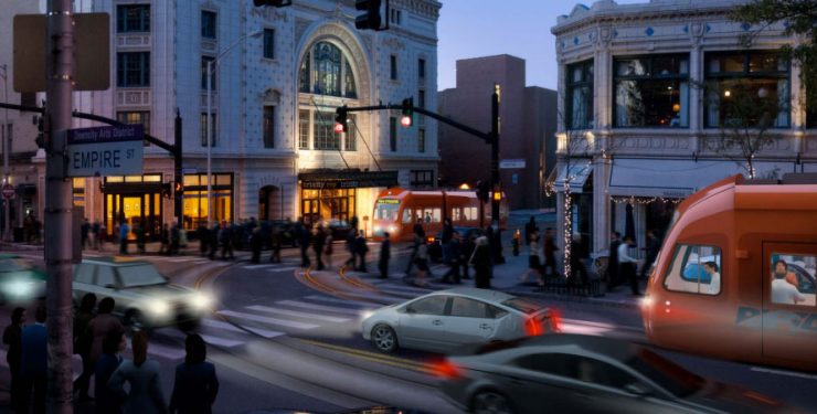
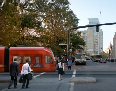
The city is currently seeking proposals for “planning and engineering services” that would include a preliminary design of a 1.6-mile streetcar line that would begin at Providence Station and end near the main entrance on Rhode Island Hospital.
The projected $100.2-million price tag is less than the original $117.8-million proposal, in part because the city is no longer planning stops on College Hill in the first phase of its plan. Future extensions of the line would include the East Side and Dudley Street in South Providence.
Dan McGowan asked me to comment on the streetcar for the “Saturday Morning Post” on WPRI.
The state can support the streetcar project and make it more successful by working to increase the speed and frequency of MBTA Commuter Rail service between Providence and Boston and extending service to Kingston Station near URI.

It’s too bad they’re cutting the ES out, my favorite part of the original plan was the use of the bus tunnel. Also doesn’t this change the meds-to-eds purpose of the original plan? Also, are we to believe this news coming a day after the PawSox owners’ tour of downtown is just coincidental?
Is this supposed to be a good thing??
Better than nothing? Have to start somewhere. Maybe this could open up an option in the future to expand from east to west, the original route up to College hill straight through to West Side/ Olneyville?
David, I think there’s future plans to expand from not only east/west but north/south so you’re in luck.They are’t concrete plans but potential plans. source: page 14/15 of the “PROVIDENCE STREETCAR” pdf. http://www.providenceri.com/efile/5439
Connecting to the train station is actually a great idea, but if they’re doing that then the streetcar should just continue up N. Main St. in future plans. That would make more geographic sense, in terms of having a linear route, and it would also allow for the streetcar to have rights-of-way. A totally different route should cover the East Side, going from East Providence to Olneyville or Silver Lake, and should meet up for transfers with the streetcar.
I still say that Exchange St. (N/S) should get transit lanes, with protected bike lanes, and be car-free. Same for Washington in front of Kennedy Plaza and Burnside Park.
I hope that the city will do all the important steps of giving this off-board payment, signal priority, its own lanes, and so on so that it will be successful. Seattle’s floundering streetcar looks like it’s headed for renewed success because the city has decide to make those changes to routes.
I agree that the train station is a superior choice, especially now that the #1 bus connects Thayer Street to the hospitals with 15-minute headways. The train station terminus will reinforce commuter train service making it more viable from both the north and south, not to mention Amtrak passengers.
The 11-minute end-to-end travel time is a great improvement. It’s about a half-hour to walk from the train station to the hospitals using a straight-ish path. The peak frequency of every 10-minutes is better than before. If headways of every 6- to 8-minutes could be achieved, the line would in almost every case be significantly faster than walking, because the wait times would be so brief.
More would use the line and use it more frequently, if instead of $2 for a one-way trip, a $2 full day pass were offered.
The fares are less important from a consumer point of view if we have robust fare systems. If you have a monthly RIPTA pass or Commuter Rail pass that also gets you on the streetcar, you don’t care how much it costs. If we put a surcharge on PawSox tickets to fund the streetcar, then maybe a PawSox ticket gets you a free round-trip voucher..? Could my Dunkin Donuts or Starbucks card also get me on the Streetcar? Can DD and Starbucks offer me streetcar points for buying coffee, or could I get coffee points for riding the streetcar? There’s all sorts of weird and interesting things that can happen with transit fares.
It could also be free.
Cutting out one of the most populous and prosperous sections of the city from the first phase is a mistake. The idea of transit is to take people from where they live to where they work and/or play. As it stands, this first phase will move through a lot of dead space and will have a hard time attracting ridership. A Thayer Street stop would guarantee high utilization.
I think this is great news, and probably increases the odds of a RIDOT train shuttle being built. It also makes the underutilized mall garage more attractive, and visiting prov by rail less confusing. Good for commuters. Good for tourists.
This is an improvement mostly if we consider this a north-south route we will expand and use fhe tunnel later for an E-W that goes from Olneyville commuter station to East Providence.
Going up either N Main or Smith Street from this path is a superior plan.
I was supportive of the streetcar going to Thayer over the train station (if we had to choose one or the other), but there are some positive things happening with the train station.
The Chafee administration (and I don’t know what the Raimondo administration’s stance is on this) was big on an in-state rail shuttle, at least Providence to T.F. Green. If we can maintain momentum on that, we could really see more frequent Kingston to Pawtucket or maybe even Woonsocket in-state rail service.
Private investors are working on commuter rail from Providence to Worcester.
Voters approved a bond measure to build a RIPTA hub at Providence Station.
The Boston Olympics (if they happen) could provide the catalysis to increase the frequency and speed of rail service on the Providence line.
There’s a lot of if’s, and many of these things would fall in place after the streetcar was in place, but if we have a doubling or tripling of people moving through Providence Station, then the streetcar to Providence Station starts to make a lot more sense.
It made zero sense to connect the hospitals to Brown’s campus. Every time they’ve done rail projects in other parts of the country they’ve always connected economically depressed areas to economically healthy areas and watched the depressed side become viable.
Connecting to Providence Station is cool though. All sorts of projects regarding train stations in the region – I know they want to expand Boston South Station too.
Have they published a route for the new line yet?
I like that the Providence Station is connected to the streetcar. I find myself annoyed when I have to travel with all my luggage from the train station to my apartment in the Jewelry District. This would be great. However, The incremental cost in having the train car connect the east side is worth it. What percentage of the ridership would originate on the east side? If it’s greater than a third, then it doesn’t make a whole lot of sense to cut them from the plan. I do however think that Brown should pay for almost the entire east side section of the track.
The extra track from the hospitals to Prairie Ave… why? I don’t understand… Why not run it on Eddy down to the JWU Harborside campus and use the streetcar to connect all the colleges. By doing so, the cost of the project can be partially put on students that use services but don’t pay for the cost of those services. There are a lot of light industrial businesses and dense residential that would be served by this line, and it would increase property values considerably. A route down Allens Ave isn’t near any residential, it seems it would be better placed west of 95, not east.
Connecting downtown to Olneyville via Broadway is a no-brainer and should be phase 2. The pedestrian-friendly layout of Olneyville Square has so much potential to be a destination for shopping/eating once it receives some attention and better accessibility. This is a long way out, but I could see Olneyville looking a lot different in 10 years when you could be a 10 minute streetcar ride from downtown.
Still don’t know why the route has it snaking a block up Point Street just to squeeze through the already narrow Richmond, Chestnut and Ship Streets. It’s convoluted at best.
There’s no real value in it taking this route, not even a substantial economic one. Move it the block or two on Eddy continuing onto Dyer and perhaps onto Dorrance Street – its a straight shot.
No matter where this thing goes, between Downtown and the hospitals, there will be economic incentives, so why not make it simpler and even more economical?
Where are Lifespan and the universities when we start talking about surcharges and the like, since its more apparent that this looks like a glorified shuttle for Lifespan employees and Brown/Med students?
Someone above mentioned connecting all the universities, from JWU Harborside to their downtown campus via RISD and to the East Side at Brown. I don’t see why some of the largest employers within the state wouldn’t reduce their rubber-tire shuttles and help contribute to a more successful streetcar system in Providence?
The original streetcar study looked at an Eddy Street alignment. It was found that due to the river, the easterly alignment reduced the catchment area of the service reducing the anticipated passenger counts (even accounting for a new pedestrian bridge at the old 195 alignment). Running the route equidistant between the highway and the river maximizes the passenger catchment between those two barriers.
Most transit planners however are not in favor of bi-directional couplets (i.e. where the streetcar runs one way on one block (Chestnut) and the other way on another (Richmond)). Providence planners prefer the couplet due to the narrowness of those two streets. A radical (radical for Providence) idea might be to make the streetcar run bi-directional all the way down Chestnut and close Chestnut to cars between Ship and Point Streets. There’s not a lot of ‘there’ there to justify a transit mall along Chestnut, but part of the whole raison d’être for the streetcar is to create development.
The key question about the streetcar is not ridership convenience (because that will always be better and vastly cheaper by bus) but its projected impact on economic development along the route — primarily the Jewelry District and 195 land since the rest of the route is pretty well developed. Will a streetcar justify its cost by becoming a true driver of development in those areas. Is it in the city’s best interest to divert about $150 million in property tax revenue to the streetcar? Could that money be better spent elsewhere (schools, police, potholes…)? Should streetcar taxes be collected from East Side and Upper South Providence for a streetcar that may reach their areas in the distant future? Will the budget really allow banking of funds for future extensions or be used up on the first segment? Should voters get a chance to approve this 30 year borrowing?
I think running it bidirectionally up Chestnut is a great idea. (I also think Chestnut should just be called S. Empire.to help with passenger wayfinding). Drivers should be reminded that having an effective streetcar will pull traffic and parking competition off the roads, making driving easier where it is allowed. The streetcar will really only be meaningful if it has rights-of-way, and Chestnut/Empire would make great extensions to that ROW.
Being able to run more efficiently (fast) will also mean being able to double back more often on an identical budget, and that means frequency. A major fault of the streetcar is its relatively low frequency of once every twelve minutes, twenty off-peak, which means if you just miss it you might as well walk. We should set out to have the streetcar compete with driving, not walking, and Jef’s suggestion is a great way to do that.
Art brings up interesting points about taxes. You know, we could really resolve a lot of the tax increment funding issues if instead of taxing buildings near the streetcar we taxed parking (or at least balanced the tax increment funding between the two). The parking tax could raise a lot of money, if passed, and I’ve said the city should put it back into lower property taxes. Earmarking the money to lower TIFs along taxed areas would be another option. The parking tax is fairest when it’s highest in places with alternatives, and the streetcar, if effectively designed, is that option. So it fits together elegantly. And it also solves a problem—why tax what we want instead of taxing what we want to get rid of? The more we push parking away from the streetcar and buildings toward it, the higher the ridership will be and the more quickly we’ll be able to extend the line to Pawtucket, the S. Side–and perhaps come up with a separate E/W line to compliment it.
I still don;t think ths will get built because I don’t see who will pay for it. The engineering being propsed is because the city got a TIGER grant for that, so I suppose they want to spend the money, but actual construction is still unfunded.
There is such a long wish-list of unfunded projects including:
the rail shuttle PVD-Airport, more extensive Airport-Woonscket, weekend service to Wickford Jct;
a commuter rail stop in Pawtucket, maybe Cranston, East Greenwich;
signal priority for other key RIPTA lines (Chalkstone, Elmwood, Cranston St…) to speed up buses beyond just the R-line;
the bus-rail hub at the train station (which if built would provide service to the hospitals just as the proposed streetcar) and maybe in the jewelry district too;
bringing the Blackstone Bike Path to central Woonsocket, Central Falls, Pawtucket, the South County path to the coast, and connecting it to URI (and more)
various sidewalks as requested by cities and towns (such as on Smithfield Rd in No Providence;)
extending commuter rail to Kingston;
Transit advocates have had little discussion about prioritizing our limited funding but I have trouble believing the streetcar being proposed woud be a consensus priority since it would mostly duplicate existing bus service. However, I will note the rr station alternative can function as more transit to the State House area (instead of ever expanding parking??) and it wouldn’t disrupt the many bus passengers who use the East Side tunnel for the long periold of construction.
There is also a question of operating decifits of the MBTA and RIPTA ($5 million next year) that is unreloved at this time, while Republicans in the US House of Representatives actually have a bill to eliminate transit and bike/ped funding from the Federal transportation bills!
Updated an old article on the difference between ROW & non-ROW transit, and I hope it’ll inspire Providence Planning & the Elorza admin. to think clearly about this.
http://transportprovidence.blogspot.com/2015/04/two-trolleys.html
> the rail shuttle PVD-Airport, more extensive Airport-Woonscket, weekend service to Wickford Jct;
This is not something that ridership supports, and frankly, neither should have been done before the next item. I don’t know many people who thinks those are more worthy, if the dollars were even the same, than the streetcar.
> a commuter rail stop in Pawtucket, maybe Cranston, East Greenwich;
These become more likely when you’ve got a last-mile ride on the street car, IMO, should absolutely happen, and are not at all competing with dollars here. We could get the Pawtucket/CF built just with the money saved on the realignment of the streetcar proposed here. But regardless, being in different municipalities, it’s not Providence dollars paying for them. I don’t see why we should at all be thinking either or here, and frankly, after we get over the NIMBY’s, MBTA is the bigger issue there than dollars.
> signal priority for other key RIPTA lines (Chalkstone, Elmwood, Cranston St…) to speed up buses beyond just the R-line;
Don’t see how the dollars compete, and this is small money relatively. Here the issue is cultural, not funding.
> the bus-rail hub at the train station (which if built would provide service to the hospitals just as the proposed streetcar) and maybe in the jewelry district too;
Wasn’t that funded with the bond that went to Garrahy Parking Garage + isn’t the realignment of the streetcar about taking advantage/enhancing the hub at the train station? In this case, not only is it not either/or, it seems to already be both.
> bringing the Blackstone Bike Path to central Woonsocket, Central Falls, Pawtucket, the South County path to the coast, and connecting it to URI (and more)
Different dollars, different hesitancies.
> various sidewalks as requested by cities and towns (such as on Smithfield Rd in No Providence;)
Different dollars.
> extending commuter rail to Kingston;
Again, this is way more valuable when you consider nursing school + streetcar for the direct path, but more than that this is not a project I’d support prior to infill. I don’t know why this state keeps reaching south (which should be served possibly better and more importantly by the extension of CT Shore line) before doing ready to go urban infill. I’d rather have an entire street car system before spending the money going even further than Wickford Junction. Kingston only makes sense with a frequently serviced EG, Olneyville, Providence, and CF/Pawtucket stop minimally, and even then, is probably going to be underutilized so long as we’re dumping at the train station with its current level of accessibility to the city.
As someone who will pay the maximum TIF rate for the streetcar, I say bring it on. It’s a good investment of my dollars. It’ll impact the value of my real estate and I’m happy to contribute it back. The biggest concern I have is getting them to rethink this path as the start of the N-S alignment and plan/engineer for a separate E-W alignment. Two lines that stretch just 4 miles each would be potentially transformative.
I think someday the E/W alignment ends up on Washington. Maybe East Side tunnel to Washington to Westminster Street (near Classical) to Olneyville. Connections between E/W/N/S are made on Washington and the entirety of Washington Street becomes a transit mall. Bus stops are removed from KP in favor of transfer along the Washington Transit Mall.
I’m drawing a map right now that does something similar, though I moved the E-W to Broadway under the thinking that a it provides a quasi-Convention Center/Dunk stop that would be attractive (and may help fund it). I’d prefer Washington to Westminster probably, however. If a tunnel was too expensive, I don’t see why we couldn’t go right through Cathedral Square (except the tight radius at Westminster and Empire).
I think the E-W terminates at Olneyville train station and continues to one or two stops in EP (though I don’t have the knowledge of that side of the river to say where).
N-S I’m less certain on because I don’t remember where the Cranston/EG station would be. Hard for me to know whether going across Public Street and down Elmwood to Roger Williams is preferred or an Allens Avenue-type alignment toward JWU south makes more sense or perhaps some third alternative. My preference would be terminating at the heavy rail station (or a possible heavy rail station site) again in the South.
To the north, I’m not sure what would be the preference if there is one direction, up North Main to the Pawtucket/CF station or up Smith Street to end (maybe somewhere around Mt. Pleasant to cover RIC or some path into RIC that can cover Mt. Pleasant HS as well? Again, I don’t know the area). One other possibility is going up one spur, then eventually the other spur and making it a U that transfers at the train station to the S line.
I wish Jason was right that there are all these pots of money for various transit and bike projects but there isn’t. Reasons include: Federal law has already cut back on support for such projects, there are few dedicated funds beyond bus replacement (and some Republicans in Congress want to elimiate those programs entirely;) RIDOT thinks they need to scarf up as much as possible for their backlog of deficient bridges; many of the projects would need to compete for very limited discretionary TIGER funds (which is funding the proposed engineering work, also helping fund the bus hubs planning;) all the projects would compete for limited CMAQ funds (“congestion mitigation air quality” in Federal highway program;) projects would compete for “new starts” discretionary funding, also very limited and coud go away if the GOP gets full control; our Congressional delegation no longer has “earmarks” but, (especially with Jack Reed’s committee assignments) could perhaps help with one or two projects but not all. And as Art said, any Providence funding has to compete with other possible uses, tax relief….
Thus I believe we do need to prioritize. I for one don’t see how the streetcar could be a priority, it has no real commuter base for significant ridership, its too slow to attract those able to walk, it competes for passengers with existing buses that cannot be reroute to avoid duplication.
The best thing to do about a streetcar is encourage planners to develop a vision of a more useful streetcar system (along the lines of the N-S and E-W routes being discussed) which could excite way more thn diehard streetcar fans. Thats the way such systems got started elsewhere and even got voters to approve sales tax hikes to fund it. Does anyone think voters here would approve a sales tax hike for this propsed system?
By the way, the USDOT is announcng another round of TIGER grants, applocations due in May-June. One of my failures from long years in advocacy is failure t have a public input process into decisions on what proejcts to apply for. Maybe with the new leadership in RI and in Providence it will be different this time.
I’m talking about TIFs and cities paying for this stuff, not all federal money of which there is little for any of it. Sidewalks aren’t getting paid for largely by federal money– frankly, even if this is an option I’m not aware of, dependency on federal dollars for sidewalks is not something I think is ok. My larger issue is the idea that bike paths throughout Northern RI (again small money that wouldn’t put a dent in any meaningful streetcar plan) or extending even further south with a commuter rail that no one is going to use before infill is worth federal monies over consolidating a better plan for moving people within Providence and supporting denser development in Providence.
Anyway, here’s how I would draw up the system, roughly. There are comments if you click on some of the items. Some areas my lines are sloppy because I’m intentionally being agnostic as to the right way to do the alignment because I don’t know enough to solve those issues (like the Henderson Bridge crossing or how exactly an alternative route on the E-W side could get over to Westminster from Washington). Lighter colors represent and are labeled as alternatives.
It clearly demonstrates how the existing proposal is well positioned as the central components of a larger system and I think presenting it in the context of this vision is wise.
Ultimately, the real fight for any kind of transit or urbanist advocate will be knocking down the 6/10 connector rather than spending enough money to build the entire map I just linked to in streetcars to rebuild it.
https://www.google.com/maps/@41.8379329,-71.4112454,13z/data=!4m2!6m1!1szYtAYqSQyjT4.k1dJiS5u-EFk
I have agreed with many of Barry’s complaints about the streetcar in the past, and I think that if we don’t push hard for a quality setup for the streetcar those problems could still exist. But the battle for us to take on right now is not streetcar vs. no streetcar, it’s quality streetcar vs. poor quality streetcar. It’s time to unite. This squabble is behind us. The streetcar is happening.
I also agree with Jason’s points about infill. Infill stations are the most important. I would add to that that bike infrastructure is even cheaper and easier to implement, and so while we’re waiting for those infill stations to go in, we should be connecting the train station to protected bike lanes. Exchange Street (N/S) is extremely wide, and could take transit-lanes and protected bike lanes. Francis Street is also extremely wide and has room for protected bike lanes.
Kingston Station stands out to me as an extension project that is far more worthy than Wickford was or ever could be, although I agree it is lower on the priority scale than Pawtucket/CF or Olneyville. The students are already fairly accustomed to biking because of the bike path, which ends at Kingston Station. Having a commuter service there would mean that RIPTA could drop the 66. In order to make the commuter line more feasible, URI needs to charge higher parking fees, stop adding parking, and do a better job of connecting the path to its campus (the big hurtle is crossing 138 at South Road–North road and South Road virtually touch and would both make good biking routes without any changes, but the crossing is treacherous).
I agree–HELL YES! I agree–with Jason’s statement about 6/10 being the big money-saving fight. It’s going to cost more than twice the Sakonnet Bridge, or 12.5 PVD paving projects if we replace the 6/10 Connector, nevermind its many other bridges that are associated with it. We should jettison that and put the money into better things.
Won’t they be replacing the end of the 6/10 connector with the viaduct? I really doubt that’s going anywhere.
They are referring to the Olneyville Viaduct or the Olneyville Expressway (Route 6 and 10 split), not the 95 Viaduct between Atwells Av and Smith St (next to the Dunk and mall garage respectively).
The Olneyville Viaduct was completed in 1951 and has long outlived its structural and functional life. RIDOT had been removing unsafe sections of it without building replacement, but they’re now down to the main section that goes over the railroad tracks and the south side of Olneyville. If they intend to keep the road, they can’t remove that segment without rebuilding at $500 million+.
Jason, This is a good effort, but am not sure that I agree with locating a streetcar route to Olneyville on either Broadway or Westminster Street. Those two streets have reasonable bus frequencies now, because they are trunk lines, meaning that two bus routes follow the same path. In the case of Broadway daytime headways are every 10-minutes because the 27 and 28 buses alternate originating from either Manton or Hartford Avenues.
If a streetcar terminates in Olneyville Square, what happens to Manton or Hartford Avenue bus service in the case of Broadway or Plainfield Street and Pocasset Avenue for Westminster?
As I understand typically a minimum of 20,000 passengers a day are needed to justify converting an existing bus route to light rail. Shorter routes that have a high number of passengers per mile can be an exception. I know that this discussion is about “streetcars,” but even the R-line with its 13,000+ passengers a day wouldn’t qualify for a conversion. Does replacing an existing bus corridor make for a successful streetcar line or light rail line?
The current Providence Streetcar modification makes several important moves, which could become a guideline for other potential routes or extensions:
1. The route originates from a major intercity and commuter rail hub.
2. The route travels through an area with a high population density and its destination is located where there’s a high number of employees.
3. With the exception of Washington and Empire a new transit route is established.
4. The destination of the new route extends to areas that have large tracts of underutilized land that have a great potential for new development.
Broadway similar to Thayer Street is uniformly built out and has limited development potential. Westminster Street, especially west of Hoyle Square and the industrial area north to the police station has more potential for development.
Would it be better to forge a new route that doesn’t replicate existing bus service that also opens up underutilized areas for development? What other alternatives might there be for getting to Olneyville? What population centers besides downtown could Olneyville connect to by streetcar or light rail?
That’s a good point. My thinking was more around having a humane design with clear E-W and N-S lines. Anchoring on the stations seemed like an easy choice. It probably makes the most sense to go south and east, with the northern routes with development potential being well served by the R-line and the western paths that make the most sense having high bus frequencies as trunks. I think I feel pretty strongly that going east means going into East Providence, going west it’s hard to see a proposal being funded that goes beyond Olneyville in the next 30-50 years IMO. I’m not sure what the best pathway would be out there in terms of development, but I could see alignments that curved up and met Chalkstone making sense (pushing the other northern route to N Main) or continuing along say Hartford Avenue as other opportunities past Olneyville (or possibly down Plainfield).
An East-West route could stay north of 6 and follow the Smith Street alignment, but I feel like that has even less development potential than any of the routes through the West End and Olneyville.
Broadly, I think a system this large moves more into the providing a cogent, permanent transit system. The E-W lines can probably be just as well served by rapid busses with dedicated ROWs, and all the other good bus practices, provided that Olneyville gets a proper commuter train station. I think it would help to brand it and link it to the N-S street. I see a full N-S/E-W pattern to be 20 years of phasing probably. It may also be that the right E-W alignment is a ROW and development corridor enabled by dumping the Olneyville Viaduct.
The strength of Providence and its urban core is that it is compact and densely populated. Its weakness is that it is organized radially. With most of Providence and Pawtucket, the main arterial streets for each are organized in a radial fashion.
I disagree with Barry and think that the last mile is critical from the train station to the CBD. Some have argued that the proposed east-west and north-south bus trunk lines that will be created by the two additional bus hubs would provide last mile service from the train station. This would be true in part, as service would be outstanding along Washington Street and the eastern edge of downtown. The western portion of downtown particularly along the Chestnut Street corridor, which has the highest development potential in downtown would not be served well by the proposed bus trunk lines, where as the proposed streetcar route would service this area.
Besides cumbersome and unpredictable regulations and taxes imposed by the city and seemingly slow decisions to come out of the 195 commission, a major contributing factor to lack of new development in the 195 land and why not as many out of state development groups have put forth proposals is the perceived lack of mass transit.
Early on at one of the 195 commission’s meetings a presentation was made by CBRE from Boston. In PowerPoint presentation showed a map of the highest office occupancies in various Cambridge and Boston office districts. The highest were at Red Line stations in Cambridge. Lower occupancies were in Boston and areas more distant from subway stops had the lowest. The presenter said that the reason why Cambridge was booming was for the most part due to the Red Line. He also commented that Providence doesn’t have anything like that, so he skipped the rest of his discussion on mass transit and development.
Even within an mostly exclusive right-of-way, the time a streetcar or light rail train to travel between Downtown Providence and Downtown Pawtucket would take a least 20-minutes. A train from Dexter Street to Providence Station would take 6 to 8 minutes. A greater emphasis needs to be put onto developing many urban infill train stations and an instate rail line and improving the existing bus service. The area’s radial configuration may make streetcar expansions challenging, beyond the current streetcar proposal.
Jason, rereading your last comment and after staring at a map, whether it streetcar/light rail, trains, or buses, some question come up.
Where are the locations of population clusters (employment, education, or residential)?
Where are undeveloped areas that could be redeveloped or rezoned for greater development?
How can those locations be connected and by what means?
What are the strengths of the geographic relationships of the urban core cities?
I think that it’s a mistake to consider phasing of 20 to 50 years for a theoretical discussion. By putting a timeline it assumes that a system(s) is already designed and it limits expansive ways to think about the problem.
This would be much easier if RIPTA’s ridership was even at early 1950s levels of 100-millon per year instead of the current 19.7-million. General Motors, Firestone and the oil companies seemed to have gotten their way at least in the Providence area for now, but that can be changed.
What’s needed is new grand vision from political leaders. If they don’t know what it is, it’s up to the grass roots to craft a vision for them. We’re not there yet and need to continue the discussion.
11 minutes travel time seems possible only with exclusive ROW. Every time I travel there, the bus (along with every other vehicle) takes more than 10 minutes to progress from Dudley Street to Point Street.
The buses beyond Olneyville should just start in Olneyville and transfer. A route termination at Olneyville makes sense because it would shorten the other routes (allowing more frequency). A one seat ride is overvalued in my opinion when transferring allows frequency, but going E-W or N-S through core areas should be one-seat. It used to annoy me that a transfer was needed to get from Olneyville to Brown area even though it was a short, unidirectional trip.
Transfers should be free. They help the system function and are an inconvenience that should rewarded with cheaper trips.
Better than buses beyond Olneyville terminating in Olneyville, buses should run through Olneyville on new crosstown routes, for instance from the southside to Rhode Island College, or from the west up Valley to Atwells or Orms.
There’s a lot of potential if we view Olneyville as a secondary hub with routes that don’t have to go to KP (because trips to KP are made with a free transfer to a streetcar at the new multi-modal station). With dedicated ROW completely doable on the majority of the E-W line (and certainly from Olneyville through Thayer Street which covers residential through employment areas and KP), good frequency also seems very possible. This would really require a vision that sees Olneyville as a strong secondary center, which is actually quite likely/possible. With no viaduct, excellent transit service, and building on already high density of residents…
If we view I195 really as restitching and expanding the fabric of Downcity (I do), than Olneyville is the spot to consider a secondary center.
My idea: a streetcar from the train station, – behind the mall – promenade st – dean st. – Spruce st – eagle sq – harris ave – olneyville sq.
It would serve several purposes: develop the valley area, create a new transit corridor, connect smith hill with Olneyville/federal hill (by improving dean st), and provide tourists a better way to get to federal hill. It would also give impetus to get rid of the dean st. on/off ramps. Also, nearly the entire route could be one ROW.
This would be after the jewelery district finally has momentum. It would replace the western half of the 92, but wouldn’t be redundant to the broadway/westminster buses.
Also, if the 6/10 viaduct really wasn’t replaced, then municipal parking plus a streetcar on that land could serve a lot of people. Going through federal hill would be bad for the reasons already mentioned. Going north would skirt those problems, I think.
Right on the money! A Woonasquatucket valley streetcar route originating at the train station and terminating at Olneyville Square. The M-MU district already allows for mid-rise high-density. Portions of the district could be up zoned near stations.
I’ve thought about that alignment because of how underdeveloped the area is. I had concerns about the geometry but it could be really awesome.
Slightly concerned about the hill for intermediate stops (Dean, etc.) but I this would definitely work if we figured that out. Alon Levy references hills as a serious challenge to transit stops, and so does Jarrett Walker.
So, I mentioned this to some people already–but I heard this idea from DFW where people staged a funeral for a highway. What if we did a funeral march? Like Pronk, but making a joke of the death of 6/10. We could get arts orgs involved—AS220, New Urban Arts, Big Nazo. We could make it like a N’Orleans jazz funeral. My thought is that we all talk about this highway a lot, but we have to seize the story and make it our own so that our bargaining position isn’t just quietly convincing RIDOT technocrats. Let’s grab people’s imaginations.
You’d really need to sell the idea to two groups: western RI, which uses route 6 a lot, and Olneyville, which might be weary of gentrification. If they could get on board, then it would be realistic.
The rest of RI should be an easy sell as long as it costs the same or less than replacing the 6/10.
6/10 or the Olneyville Viaduct is a side issue to the streetcar, which should be part of another post.
If they were to downgrade or diet the viaduct to a street or boulevard, a new bridge would still have to be constructed over the railroad tracks.
If viaduct were just eliminated, the traffic though Olneyville Square would become absolutely horrific. Other than the North-to-West ramp dump into the square that happens today, traffic from the entire highway would be dumped on the square, which would be 3 or 4 times current traffic levels.
If the length of the Olneyville viaduct and the 6/10 connector to 95 were dieted and dropped to grade level becoming a boulevard, new opportunities become possible:
1. The railroad right-of-way could be widened to accommodate five tracks and two platforms similar to what is proposed in Pawtucket for an Olneyville train station
2. The highway embankments on the north side of Federal Hill could be developed for high-density housing and retail.
3. Besides a streetcar on Promenade, if a streetcar were to divert to Dean St, it could travel along the new boulevard before returning to Harris Av or Valley St.
Whether it’s Spruce or a new boulevard, an alignment that goes to Federal Hill adds the population component that would be lacking, if the streetcar route just followed the river to Olneyville from the train station.
I would definitely propose adding transit capacity, although as a matter of fact I don’t think removing Rt. 6 would create any additional traffic with or without.
Take for example the sudden collapses of several highways–in the 70’s New York City lost the West Side Highway, which carried tens of thousands of cars, and no added traffic happened. In San Francisco, several highways have collapsed due to earthquakes, and no traffic congestion was felt. The explanation for this is that the roads themselves create induced demand to drive, and make it difficult not to drive by blocking any other methods of travel.
See the video! http://www.streetfilms.org/mba-highway-removal/
A lot of my personal experience of being on this highway has either been with drivers making very short trips (that shouldn’t be on the highway) or on RIPTA buses (that also shouldn’t be on the highway). I feel like the highway is actually causing more traffic than it’s relieving.
As to western Rhode Island, I would say that Rt. 6 beyond Olneyville would probably be untouched. And as a matter of fact, as I understand it, Rt. 10 would be the most likely route to come out first, because it’s very old, while some of Rt. 6 has been updated recently. So we could remove the highways piece by piece.
As to gentrification, what I would say to that is that if it costs less than $500 million to do something other than this highway, then why not put the remainder into some kind of programs of social uplift? Better schools, expanded social services, affordable housing. And on top of that, the sheer additional land and opportunity to develop market-rate housing would stabilize housing costs while building jobs. The alternative is to put all that money into a route that 45% of the neighborhood can’t ever use, and make them suffer through pollution and degradation for nothing.
I think you made a good case here, too: http://www.ecori.org/transportation/2014/4/11/routes-6-and-10-put-providence-in-chokehold.html
WPRI has an udate 4/15 indicating there will be an ordinance introduced to authorize city borrowing of $57.7 million in bonds to help fund the capital cost of the project whose total cost was a estimated to be a bit over $100 million. For only 1.6 miles that is over $62 million per mile. The article indicates they still must find an additional $30 million somewhere. And don’t forget the $3 million/year operating deficit, but the city isn’t so worried about that as it will have to be made up by the state, or by RIPTA at the expense of its bus passengers.
The bonds are to be paid back by “tax incremental financing” by the taxes on any properties downtown, College Hill or the jewelry dstrict that become more valuable due to the streetcar. But if the enhanced values do not adequately materialize, the bonds will have to paid back anyway at the expense of all the taxpayers in PVD. (As if taxes weren’t high enough already)
WPRI notes only 2896 daily riders are anticipated, which even seems optimistic to me as it is hard to see that much demand at $2 ride. (However we did bring up restoring the old low fare “short zone” at the Ripta fare hearing.) Frankly it seems ludicrous to build all this expensive infrastructure for so few, especially as they have existing bus alternatives.
WPRI: Providence wants to borrow $57.7M for streetcar
Perhaps related, at his confirmation hearing, RIDOT Director Aviti, in response to a question about RIPTA from a Senator said we need to consider “rapid transit” as part of any Route 6/10 reconstruction project. Earlier he referenced linking modes together better, but othr than that I didnt hear anything about the streetcar, commuter rail, or bike infrastructure.
Let’s see.
Let’s make transportation more expensive in a state that is about broke.
Lets add the cost of a tiny short run theme park ride to it.
Will this provide any new service to anyone?
Well, no.
Streets go everywhere, buses, cabs, limos, vans and private autos use them.
The streets need upkeep no matter what
So here is a none-too-clever idea for adding to the overall cost of transportation infrastructure while providing no new services.
Umpteen thousand of residents will be slammed with higher taxes “because the streetcar makes your home more valuable”… so the assessed value goes up and so does taxes.
Of course, the homes will NOT be more valuable.. few who are assessed will be on the route but blocks away from it. Most homes will drop in value, because of the tax rates that will be imposed… and a theme park ride isn’t going to offset that.
ProJo: Providence City Council begins review of streetcar proposal