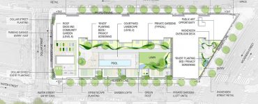
Archives For South Main Street

Providence Bicycle and Pedestrian Advisory Commission Agenda
January 23, 2013, 4:30 PM, 444 Westminster Street, First Floor

Note: Meeting is Wednesday instead of Monday due to the Martin Luther King Day holiday. Also, meetings start at 4:30pm now rather than 4 o’clock.

  1. 4:30 – Nate Urso, Providence Department of Public Works: Crosswalks, Street Repaving, Policy, and Safety (Nate will also give a brief update on the status of the Road Bond repaving in general)
  2. 4:55 – Dave Everett: Bike Plan Update and BPAC input on potential road bond bicycle improvements (Melrose, Prairie, Potters, Olney) and review of typical sections. Also plans for draft report and stakeholder meeting in Feb.
  3. 5:05 – Public comment.
  4. 5:20 – Discussion/letter re DOT bikeway plans (master list for bike plan)
  5. 5:25 – Jef Nickerson: S. Main St. merchant issues re pedestrian access/movement relative to I-Way parcels
  6. 5:30 – Jenn Steinfeld/Jef Nickerson: BPAC communications update/protocol for receiving input
  7. 5:40 – Bridge detours update
  8. 5:45 – Zip Car spaces and potential bike lane conflicts
  9. 5:55 – Rescheduling BPAC meetings now scheduled for May 20, August 19, November 18, December 16

Full disclosure: I am a member of this Commission.

GC: Photos – More snow photos!

gcpvd —  December 31, 2012 — 1 Comment

Some more photos from our readers have been added to our Flickr Group, share yours too!

New Ice

Photo © filledtoovercapacity

Snow

Photo © Jerri Moon Cantone

Continue Reading…

GC: Photos

gcpvd —  January 15, 2012 — Leave a comment

A selection of photos readers have recently shared in our Flickr Group:

The Mounted Command Providence R.I.

Photo © BlueisCoool

Untitled

Photo © Paul Shelasky

Continue Reading…

UPDATED: Reader Photos: Irene

gcpvd —  August 28, 2011 — 1 Comment

Readers are starting to submit their Irene photos. Share yours in our Flickr Group, on our Facebook page, or via email.

Peel

Photo © Golden Meanie

Blockade

Photo © Golden Meanie

Stinko

Photo © Golden Meanie

Continue Reading…

GC: Photos

gcpvd —  June 12, 2011 — Leave a comment

A selection of photos readers have recently shared in our Flickr Group:

getting lively in providence
Photo (cc) lumpyoatmeal330

First Unitarian Church
Photo © boliyou

Continue Reading…


Photo (cc) provbenson2009

A reader submimtted this photo of a heart painted snowbank outside L’Elizabeth’s on South Main Street to our Flickr Group.

RIDOT will be closing Exit 2 (South Main Street) off of Route 195 westbound this weekend. The closure will allow RIDOT to reconfigure the ramp and prepare for further demolition of the old Route 195.

RIDOT:

On Friday night, June 4, RIDOT will begin a weekend-long operation to relocate the ramp for Exit 2 (South Main Street) from I-195 West. The ramp’s entrance and exit point will be changing, and for the first time there will be a traffic signal at the end of the ramp.

In order to complete the work necessary to relocate the ramp, RIDOT will close Exit 2 for the entire weekend. The ramp will be reopened before the morning commute on Monday, June 7. Motorists seeking access to the East Side of Providence should use Exit 3 (Gano Street) or Exit 1A (Point Street) during this time.

Exit 2 currently carries motorists on a bridge over Wickenden Street and then merges into South Main Street. The new off ramp will meet Wickenden Street at a traffic signal. The new intersection will feature three lanes, and allow access to Wickenden Street, Point Street and South Main Street in the following manner:

  • Left lane is for left turns onto Point Street. Motorists also can proceed straight onto South Main Street.
  • Center lane allows through traffic onto South Main Street only.
  • Right lane allows right turns onto Wickenden Street only and provides access to Benefit Street.

Images from RIDOT

In Part 4 much of the discussion revolved around lot sizes.

Comment by Corey

Call me naive, but personally, I would take some of the parcels not targeted for institutional use, subdivide them, and then sell the subdivided lots individually; much more in line with what would have been done in the 18th or 19th centuries. [...] It also allows a lot of building form regulations to be relaxed without risking so much insensitive development.

  • By allowing room for numerous property owners to have building facades on the same block, you’re almost guaranteed not to have a block-long dead space in any part of the district, because a variety of different uses and architecture occupy each street front.
  • By encouraging buildings with smaller footprints, building heights and proportions tend to be harder to abuse, decreasing the need to spend the time and money on the exhaustive specific zoning regarding height, mass, and proportion which tends to scare away developers. If anything should be exhaustively regulated, it’s materials and energy efficiency.
  • Multiple tenants on each block = greater density, and greater variety of uses, which means:
  • A more constant street life at all times of day, as well as greater walkability, and demand for mass transit expansion.

If anything has been proven to work in Providence, it’s the repetition of historical development patterns. There’s plenty of evidence to support that, and plenty of wiggle room for dynamic new buildings within those patterns. The 195 relocation project in and of itself reflects the fact that the city planners realize this. It just needs to be taken one step further in order to really work well here.

Read through the discussion to see more of the conversation.

The massing renderings below show several different configurations of lot sizes on the east side parcels of the 195 redevelopment area:

001-large-lots-full-block

Large full block lots • Click image to enlarge

002-small-lots-some-combined

Small lots, some combined • Click image to enlarge

003-small-lots-after-development-pressure

Mixed lots after development pressure • Click image to enlarge

195_iconThis is the fifth of a series of posts we will be doing about the 195 Street Grid. To view all the posts and more information, please visit our 195 Relocation Project page.

View Larger Map

As the Iway project moves along, RIDOT and the city are looking at the rebuilt street grid below where the highway now stands.


See the RIDOT plans here:

Download RIDOT Street Grid Plan (east of Providence River)
Download RIDOT Street Grid Plan (west of Providence River)


While the rebuilding of the grid may seem to be a simple project of reconnected streets that were removed by the highway, there many issues to consider. The City held two meetings recently to give the public an opportunity to view and comment on the plans. We will be looking at some areas of concern that we have for the proposed grid here at Greater City: Providence. We start off on the east side of the Providence River looking at the Wickenden Street area and looking at an alternate plan proposed by Landscape Architect Ron Henderson of L+A Landscape Architecture of Providence.

First let’s look at RIDOT’s proposal.

Continue Reading…