FeaturedGovernment Providence City Plan Commission Meeting – October 29, 2019 Greater City ProvidenceOctober 27, 2019
195 Relocation Project I-195 Redevelopment District Commission Meeting – December 19, 2018 Greater City ProvidenceDecember 16, 2018
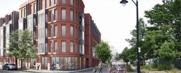
195 Relocation Project ‘The Row at College Hill’ proposed for 195 District Parcels 2, 5, and 6 by The Carpionato Group Jef NickersonApril 11, 2018
EventsParking City announces free parking for local shopping for the holiday season, #ThinkPVD Greater City ProvidenceNovember 25, 2016
BicyclesPedestrians Providence Bicycle and Pedestrian Advisory Commission Meeting – August 20, 2014 Jef NickersonAugust 19, 2014
195 Relocation ProjectGC: PhotosReader SubmissionsVideo GC: Photos (& Video) – 195 Demo Greater City ProvidenceJune 18, 2011
195 Relocation ProjectGC: Photos GC: Photos – Some cool Old Route 195 demo photos Greater City ProvidenceJanuary 25, 2011
195 Relocation ProjectRoads 195 Wickenden Street exit to close temporarily this weekend Jef NickersonJune 1, 2010
195 Relocation ProjectParks/Open SpaceReader SubmissionsRoads Debra Booth: The other end of Wickenden Street Guest PostApril 19, 2010