Click image to enlarge
REBOOT is an occasional series of posts on Greater City Providence where we identify areas of the city that display poor urbanism and propose ways to improve them.
Our interventions may be simple and quite easily realized, or they may at times be grand and possibly take years or decades to complete. Either way, we hope they generate interest and discussion.
Beneath College Hill there lies what could someday be the workhorse of our metropolitan transit system, a tunnel. Not the one the buses and trolleys run through between South Main and Thayer Street, a rail tunnel. The East Side Rail Tunnel has been sealed up since about 1993, no trains have run through it since round about 1976. Built for under $2 million in 1908, the tunnel provides Providence with untold savings in trying to jump start a regional rail system.
So where is this tunnel? Know that big blank concrete wall between Cafe Chokolad and Mill’s Tavern on North Main? The entrance is up above there. The tunnel runs under College Hill passing under Thayer Street near Waterman Street and emerging just west of Gano Street. The tracks out the west portal continue toward the erect bridge over the Seekonk River.

In the past the tunnel provided passenger rail service between Providence and Bristol and Fall River. Later passenger rail was dropped and freight trains used the tunnel. Before it was sealed off, it was proposed that the tunnel would be used as an automobile expressway connecting Route 6 to Route 44 (that’s part of the reason for the Henderson Bridge). Today the tunnel is just sitting there. It is time for us to put it back to use.
Mayor Cicilline proposes using part of any stimulus money Providence may get from the Obama administration to study and build a Downcity streetcar line. As part of that planning I say we plan to re-use the East Side Rail Tunnel for light rail service to East Providence, the East Bay, and points in Massachusetts (maybe even all the way back to Fall River).
How and where those eastward rail lines would go we’ll discuss in Part II, now we want look at how will trains get into the tunnel.
The tracks leading into the tunnel were part of the “chinese wall” of elevated rail lines between Downcity and the State House which were removed to make way for the River Relocation Project. Because of this the tunnel portal sits above street level. The easiest way to reconnect rails to the tunnel is to build another elevated structure.
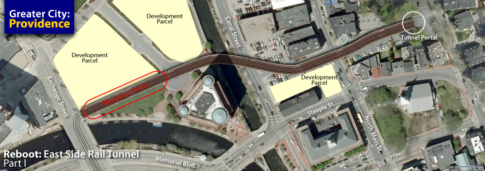
The Illustration at the top of this post shows a possible route for a new elevated light rail line. Tracks would emerge from the tunnel under Benefit Street between Mill’s Tavern and the Providence Art Club and travel on a viaduct over North Main Street and the Metropark lot at Steeple Street. The viaduct would then make an S-curve crossing Canal Street and the Moshassuck River to run behind the Citizens Building. The viaduct would then meet Exchange Street where a station could be built across from the Waterplace condos. Trains would continue on Exchange Street into Kennedy Plaza. From there they could head west and/or south to serve the rest of the city.
Alternately a station could be located right at the tunnel portal above North Main Street. However I think the Waterplace location makes for a better station. It sits a quick two block walk from the Amtrak Station, is in the center of a dense residential area with Waterplace Condos, Avalon Apartments, and the Capitol Cove Condos nearby, and sits within a block of the Citizens Building, the future BCBSRI Headquarters, the AmEx Building, and amongst parcels that could see dense office and/or residential development in the future.
Currently there is a parking lot where the tunnel portal is, the area between the portal and North Main Street could be excavated to allow for this parking to be moved down to street level under the new tracks.
An elevated rail line! Are you daft?
Yes, we did tear down the “Chinese Wall” because it created a barrier between Downcity and the State House. Yes, we are tearing down Route 195 because it creates a barrier between Downcity and the Jewelry District. Yes, people in Providence would not be all too enthused to build a new elevated structure Downcity. However, an elevated structure need not be a barrier.

This 1954 photo from Art In Ruins shows that the old elevated structure was quite wide, wide enough for up to four tracks. The new viaduct will only need to be wide enough for two tracks. The old structure was also built over 100 years ago, with over 100 year old engineering. It was a massive stone and steal structure.

This photo by sillygwailo from Flickr shows the underside of the Vancouver SkyTrain. A new light rail viaduct in Providence can be a slender structure with pleasing ornamentation and lighting. Areas beneath the viaduct should be properly programmed to allow for seamless integration of the streetscape. At the Waterplace Station for example, a small restaurant or cafe can be installed with outdoor seating along the riverfront at Waterplace park. At North Main Street development of the Metropark Lot will create a solid streetwall on the west side of the street.
Can’t there just be a ramp for the trains to climb?
Well, yes, there could be. I don’t know the exact height of the portal above North Main and I don’t know the maximum incline that a light rail vehicle can climb, but it is likely possible that a ramp could be built between North Main and the portal to bring trains up into the tunnel. However, if we bring trains down to street level, then they will have to travel in the street. As anyone who has ever traveled in this area knows, the streets in this area are highly congested, especially at rush hours. Putting trains into the mix will only worsen that congestion and result in trains being stuck in traffic. Putting the trains on the street could easily add 5 minutes to the trip between Kennedy Plaza and the tunnel portal. Building the viaduct keeps the trains and cars separated, allowing each to move freely.
Why do we even need rail to the east?
There are only two crossings from Providence to points east, the Washington Bridge and the Henderson Bridge. All commuters and visitors to our city from points east come through these two points. RIPTA route 60 which serves the East Bay has a high level of service and dedicated passengers, but the bus has to sit in traffic with everyone else. And aside from Route 60 and a few East Providence buses, there’s not much in the way of mass transit bringing people in from the east. Without the water barrier, people have more options coming in from the west. From the north we have Commuter Rail and that rail is being extended south. The East Side Rail Tunnel provides the best option for moving people into the city via mass transit without making that transit sit in the same traffic that people are trying to avoid.
In the next REBOOT we’ll be looking at the eastern portal of the tunnel and exploring some of the easterly locations that could be served by transit running through the tunnel.


I love this idea, especially that light rail elevated structure. How about a real live subway station under Thayer Street!
We do need to compare the cost of that elevated structure to excavating the floor of the tunnel so it descends to exit at street level, provided that signals and lanes can be configured so transit vehicles are not delayed in traffic.
Another idea is to reroute the western end of the rail tunnel so it merges with the existing bus tunnel and shares that portal, again provided that transit vehicles have priority over other traffic. (This is something that should have been done for the buses already, stupid governor).
Brown University/Thayer Street is a critical destination that is not served by this rail tunnel unless a frightfully expensive underground station is included. Just keeping those escalators in repair could break the system.
Sadly, I think love for that tunnel is making us assume too quickly that it should be the the star of Providence’s rail transit revival. Maybe someday traffic will justify an East Bay Rail Express. Meanwhile, compare this cheaper alternative:
Light rail through the existing bus tunnel traveling Waterman and Angell to and from the Henderson bridge. True, the trip would take longer than shooting through the rail tunnel, but existing transit oriented neighborhoods, College Hill and Wayland Square, would be beautifully served, instead of bypassed.
Hey Jef, please get on your Illustrator again and draw for us my proposed North Main Light Rail Elevated Connector:
Structure begins on North Main Street just south of the end of the Moshassuck apartments, curves west to cross Charles Street (Mill Street, whatever), the Moshassuck River, and Amtrak. Curve south to cross Smith Street at grade. Staying elevated above the Amtrak tracks to enter a new bi-level Providence Station would be cool, but economy suggests moving Gaspee street closer to the State House to make room for the new tracks which then curve past the station to proceed to Kennedy Plaza via Exchange Street.
This would cut 5 minutes off the trip between Downtown and University Heights and provide a much needed direct connection to the train station. Getting North Main Street traffic off the Steeple Street bridge will reduce congestion around a possible street level entrance to the old train tunnel. The tunnel could simply be paved to provide an easy to implement express route for bus service to East Bay.
Just tossing off some ideas.
Lovely idea, but what is at the east end of the tunnel? I know that the rail bed in East Providence is still available (the original right of way is now the East Bay bike path, correct?), but I am not very clear about where the tunnel exits at Gano Street or if the land between the tunnel exit and the bridge is still available.
Please keep ideas like this coming.
In the little inset from 1970, they talk about hooking up this bypass road with the “new red bridge.” You know, the one with lanes and exit ramps closed cuz’ it’s falling down…
Seriously, ever since I saw Michael Singer speak at New Commons, I feel like there could be enormous leaps forward in all the aspects of everything. His approach is so smart and so practical that I’d love to see it applied to issues like this:
–> how to design a truly light light rail system – lighter than anything built so far
–> how to design a construction regimen that’s fast and has a minimal footprint so it could quickly be implemented along, say, a working bike path
–> how to take orders of magnitude out of the entire operation with transformational concepts like designing a rail system that can use a single track to carry passengers in both directions
There’s lots and lots of industrial design capacity at RISD, but until it’s challenged/inspired/paid to concentrate on breakthrough technology, it won’t.
I believe the RiverLINE in New Jersey runs bi-directional on one track.
I was just researching that portal today. The last freight train went through it in 1981.
I think Jef is spot on with the idea of using the rail tunnel as a key to a future city rail system. Linking Fall River is the next logical step in the evolving rail plan. Fall River and New Bedford together with greater Providence, make up a metropolitan area as defined by the US census bureau and various demographic and economic related departments.
I love the idea of using the elevated approach to link the eastern part of this line to the portal. The western end can simply follow the old ROW to Fall River (or at least to the RI/MA line until MA gets on board (more on that after Jef presents hsi ideas first). My only variation to this idea would be to have the line connect to the Amtrak station instead of KP. In my version, the line would exit the west portal, cross N. Main, turn right until it aligns with Park Row West and follows that (elevated) to a new upper level station just east of the existing Amtrak station above the part of the existing platforms stick out from under the station.
Why? I just think that this type of rail line needs to be linked to the MBTA/Amtrak service to Boston (and points between), the airport, Wickford, and eventually Kingston and Westerly (possibly Cranston and East Greenwich), and the possible rail service on the P&W line up to Woonsocket and points on the way there as well as a possible southern branch to the “P&W” commuter rail line to Quonset. This line would still be light rail per se, but not so much part of the streetcar system. More designed for the longer trip to Fall River. This idea would allow a 1-connection rail trip from 5 key corners of our metro area. Westerly, Woonsocket, Boston, Quonset, and Fall River, with the ability to tranfer to any of these corners and places in between. RIPTA and street cars should then connect to smaller nodes, lines, and places in between the places that have a one of these rail station.
I LOVE this topic BTW!!!
A great longitudinal idea, as always, but in the mean time I think we’d all love to hear your thoughts on where the proposed first streetcar line would/should go. There has been all this talk about it by the mayor and others, but I have yet to really see anyone come forward with a proposal for how to make one streetcar line efficiently cover as much ground as it can. My two cents: it should exploit the existing patterns of traffic and commerce in order to avoid unnecessary construction and disruption of the street grid, and in doing so take advantage of where and how streetcars historically ran in Providence. I would run this line as a loop (thus being able to accommodate more cars at a time), along an east-west corridor defined by the city’s main commercial and cultural districts, using streets that have traditionally been wide enough to support both traffic and transit.
For this, I’d suggest using the current bus tunnel rather than the rail tunnel, as someone suggested already, and having the cars run east on waterman, loop through wayland square, and head back West on Angell. They could then continue west to stop in front of Union Station, then up Sabin across the highway to Broadway, doing another loop in Olneyville Square to run back east down Broadway into downtown, making a right onto Empire and a left down Weybosset through turks head, Kennedy Plaza, and a right on Washington to get back to the tunnel where we started. It sounds a tad complex, but it would cover pretty much every one of the city’s most popular, pedestrian oriented areas without actually disrupting the existing traffic flow or having to heavily reconfigure streets.
Suggested stops along this line:
South Main and Washington
Thayer and Waterman
Wayland Square
Thayer and Angell
Union Station
La Salle Square/Civic Center (both ways)
Broadway and Dean (both ways)
Broadway and Knight(both ways)
Olneyville Square
Weybosset/PPAC
Turk’s Head/Kennedy Plaza
It may not be able to drop everybody off exactly in front of where they want to go, but it will get them within a few blocks, and connect some key areas where proposed projects have stalled and development is lacking. With adequate maps and signage, it would be quite easy to navigate. The only thing that I can’t figure out would be how to reconcile it with your proposed light rail station at Waterplace. I suppose that can always be pieced together with later streetcar lines.
I’ve been ill so I haven’t been able to keep up with the comments here. I’m reading through them now and will be incorporating some into the next REBOOT.
As far as the street car lines, I’d begin with the busiest (within the city) RIPTA lines (maybe the trolley lines?). On-street parking along the routes that are chosen will also need to be reduced or eliminated to allow for better flow of cars (in motion) and the street-cars. This could also promote 2 things: parking lots might become garages and less parking = more reason to use transit. I think one of the first basic lines needs to link KP and Providence Station to allow for better intermodal connection throughout the entire system.
Hope you feel better Jef…
I really like Corey’s idea. I would like to see this light rail system also extend from Pawtucket to Cranston to serve the immediate metro while being sure to make use of the Broad Street Corridor (stopping at Roger Williams Park, of course), which is among RIPTA’s busiest lines if I’m not mistaken. That’ll provide more tranist options for that area. Buses and light rail – horay! Montreal has a great system using free transfers between rail and bus. I think it works well.
San Francisco also has a system with free transfers. You pay the toll when you board, and a little voucher prints out with a time on it. All your rides are free until the time printed on the voucher expires.
Does SF do “Proof of Payment” or honor system fare collection? That River Line mentioned above does. It makes a lot of sense. When it seems to take forever for people to get off and on the bus, I get this message: Better that all you slobs have your ride take twice as long than have one of you sneak on for free. No wonder there are still so many people who will not consider using the bus.
If all you need to ride is a pass or self-validated ticket, buses or streetcars can have several large doors so people can hop off and on quickly. The savings from cheap equipment and tickets instead of high-maintenance electronic fare apparatus go into spot check enforcement of proof of payment. Those ever moving officers provide better security and customer service for passengers. Drivers can focus solely on driving.
Andrew – I’m not exactly sure what your question is. There is some sort of proof of payment involved, but it’s done in sort of a loose way because the point of the system is to make the intermodal aspect of the city’s transit run as smoothly as possible. San Francisco probably has more transit options packed into one city than anywhere else in the country: Bus, Subway (Muni, BART and Caltrain), Streetcar, Trackless Trolley, and Cablecar. It almost always requires more than one mode of transportation to get where you need to go, so the transfer vouchers are designed to let that happen without holding up the works at every stop. It seems to work very well for them, although I did have one qualm:
You have to pay the fare ($1.50) in coins, but the change machines only dispense dollar coins. You overpay by 50 cents half the time if you’re not completely anal about hoarding quarters.
Corey,
In the system I am talking about, there are no turnstiles, and no line to swipe or pay as you enter a bus. But you must be ready to show a pass or stamped ticket while you are riding. Tickets are sold at vending machines and in stores. There are time stamp machines near the doors of the buses so you can stamp your ticket yourself and then you have 2 hours to ride around, transfers and all.
So. in SF do you line up to pay the $1.50 as you enter the bus or trolley or are there change machines at the stops? And if you have a valid ticket and you are transferring, does the driver have to examine it or can you just hop on?
Andrew,
I know the kind of system you are talking about. Proof-of-payment is much more common in Europe, though there are some systems in the US (especially newer systems) which use it. The RiverLine in NJ uses it.
I was last in SF more than 10 years ago, back then they did not use a P-o-p system (not sure what they do now, but I assume it hasn’t changed). I found SF to be very confusing. They have several different transit systems, MUNI, BART, and CalTrain in the city and some other systems in other communities such as San Jose. Each system runs it’s own fare collection, though there are provisions to buy multi cards (i.e. fare cards that will work both on MUNI and BART). I bought my first fare at a station near the Airport (BART didn’t reach the airport yet when I was there). And I bought a multi card but ended up getting way more than I needed because the fare machine confounded me.
Boarding the MUNI trolleys you had to pay the fare at the entrance to the train, just like Boston.
I agree that if/when we have trolleys a Proof-of-payment system would be ideal, since many of our trains would be running in the street.
Previously, someone asked where the east end of the tunnel was. Here is the google map of the location. You can see it exits just east of the intersection of Gano and Amy streets.
View Larger Map
The only problem with this plan is that no one wants to go to Fall River or New Bedford. They are dead end cities between Providence and Spain. And now that the Iway is built, I doubt money will be spent on this tunnel.
I think a better idea is a bridge south of I-195, connecting Conimicut with Bristol. This will avoid having to drive through Providence to get to points east.
One thing that is essential ,is keeping Fall River& New Bedford in our orbit.All fun and games with the “Spain ” comment,but these historic and living urban areas are part of the metro. No,I disagree;build it and they will ride,Keep in mind it goes into the East Bay which 195 does not do.
I think that it makes sense to bring this topic up again, considering that our last governor toured the tunnel in 2013 and we still haven’t made any meaningful progress towards exploring the repurposing of this amazing asset. Since the streetcar plan has been defeated, we should explore other options.
Run a gondola from the North Main entrance (or Canal Street) through the tunnel with a stop at Thayer, a stop at Gano, and bring it over the Seekonk River to East Providence. It is by far the most cost effective way to add a great (unorthodox) transit asset on the cheap, and connect three communities to downtown (Brown/East Side, Off-Gano, and E.P.).
Ski resorts routinely install this equipment on far more difficult terrain, at distances greater than a mile. Cities are increasingly using gondolas for transit and we should explore it too.
According to CityLab: “Running subway lines under a city can cost about $400 million per mile. Light rails systems run about $36 million per mile. But the aerial ropeways required to run gondolas cost just $3 million to $12 million to install per mile.”. Since the tunnel is essentially flat, the cost should be on the lower end of the scale. Involving E.P. could help spread the cost of the project over a greater number of citizens served.
You know, I never really gave gondolas any serious consideration as an alternative to street rail, considering the limitations in stops and number of passengers, but this honestly seems to make a whole lot sense.