On Monday the city Planning Department and RIDOT showed updated plans for the street grid that will be built when Route 195 is torn down. They showed the entire plan area on both sides of the river, most people in attendance were most interested in the Wickenden Street interchange alternatives. I will look at some things about the west side in a later post, but now I’ll focus on Wickenden.
Three alternatives for Wickenden were presented, let’s look at them:
UPDATE 02/05: I neglected to mention that the City and RIDOT are accepting comments on these alternatives through the end of business on Tuesday, February 16th. Contact Melanie Jewett in the Planning Department and/or Lambri Zerva at RIDOT.
Alternative 1
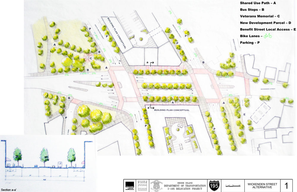
Click image to enlarge
We can basically call this the RIDOT alternative. In this option, the right turn lanes from Point Street to South Water Street remain. This was resoundingly rejected by those in attendance. Other changes from the original proposal include the number of lanes on Wickenden eastbound and the number of lanes on South Main from the highway is reduced from 4 to 3.
RIDOT also originally proposed a pathway through the center of the median as a way to move pedestrians and bikes from the southeast corner to the northwest corner. This pathway is eliminated in favor of those movements being made more conventionally through regular crosswalks.
Also, Benefit Street now wraps around the church from Wickenden to Traverse. Previously, Benefit rounded the church from Traverse, but dead-ended short of Wickenden. This section of Benefit, which currently runs northbound past the gas station will be turned around and now run southbound.
Alternative 2
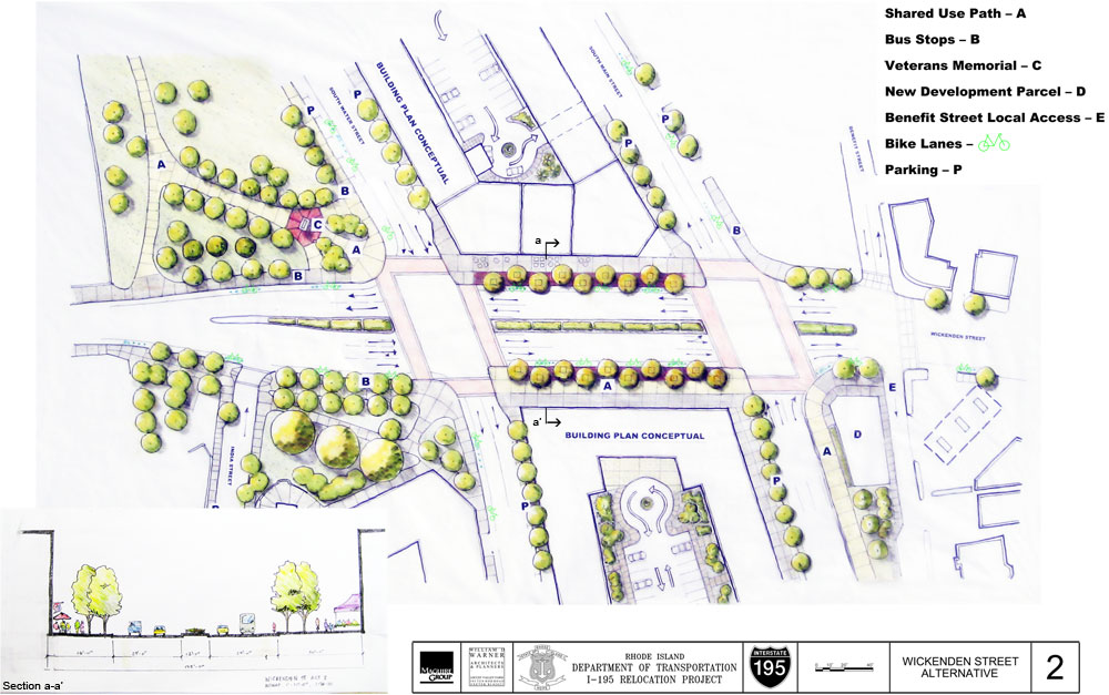
Click image to enlarge
Alternative 2 and 3 are quite similar, to each other and not terribly different from the RIDOT alternative, the odious right turn lanes on Point Street go away in both alternatives. Alternative 2 retains a median on Wickenden Street, however that median is narrower than the RIDOT plan.
The lane reductions and changes to Benefit Street remain the same.
Alternative 3
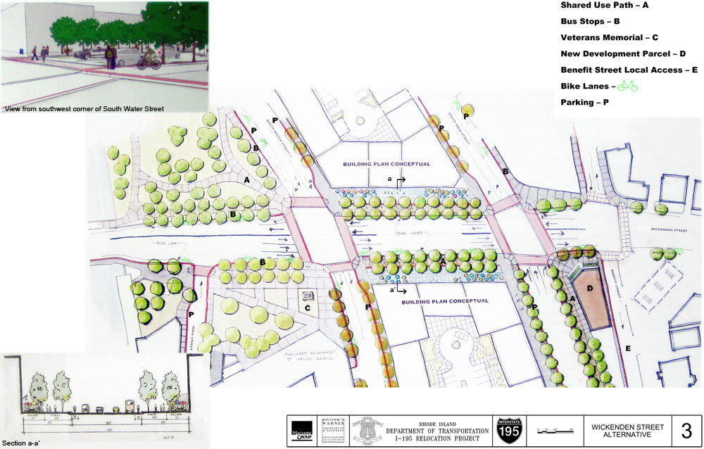
Click image to enlarge
Alternative 3 is much the same as 2, the key difference being that their is no median on Wickenden Street.
To median or not to median
I left before the end of the meeting, but the consensus in the room seemed to be forming around keeping the median, this also seemed to be RIDOT’s preference. RIDOT was pushing the safety benefits of the median as a pedestrian refuge and I have to say, I do agree with that.
Anyone who has ever crossed Memorial Boulevard at College/Westminster (or watched the RISD students do it) knows how intimidating crossing four lanes of traffic can be. Consider being physically challenged or having small children in tow and it becomes even more daunting.
Of course there are urbanist arguments for not having a median. A street without a median is simply more urban in style. There is also a traffic calming effect of having cars traveling in direct opposition to each other, oncoming traffic encourages people to slow down. Funneling traffic into a one-way reservation can encourage drivers to move faster. The length of the median and the number of traffic lights in a short distance should not allow for traffic to pick up these speeds, and I for one feel better with the median for refuge if needed.
Pike Street
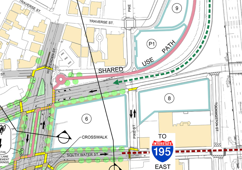
Click image to enlarge
I was shot down on this, but I would like to see Pike Street extended all the way through from Traverse Street across South Main to South Water Street. Current plans have Pike ending at Traverse then picking up again as a one block street between South Main and South Water.
RIDOT does not like this because RIDOT does not want traffic backing up onto the highway. I can understand this, there is a danger in having traffic back up onto the highway (of course it happens all over the place and accidents tend to be few). The problem as I see it, is the ramp from the highway merges with South Main and does not actually meet (and acclimate to) city streets until it reaches the light at Wickenden. Having a light at Pike Street slows highway traffic sooner. I think adding a lane to the ramp to allow for stacking and timing lights (making longer greens at the morning rush) can alleviate the back ups onto the highway. The danger of high-speed traffic penetrating all the way to the Wickenden intersection is a bigger danger in my opinion as it impacts pedestrians and cyclists.
Running Pike Street all the way through also re-establishes the street grid south of Wickenden, allowing more areas for local traffic to move around.
The new jug-handle
Anyone who has travelled through this area is aware of the jug-handle that swings traffic around to make the left onto Benefit. That jug handle goes away, but RIDOT plans to create a much larger jug-handle going in the other direction.
Westbound on Wickenden, traffic will be prohibited from making a left turn onto South Water Street, which is the way to get to Route 195 eastbound. Instead, traffic will make a right onto South Main Street, a left onto Dollar Street (which is a new street before the current James Street), then a left onto South Water Street (where there will be a traffic light), then proceed straight through the Wickenden intersection and off toward 195.
This was very unpopular among those in attendance. The reasoning on RIDOT’s part is that the current left turn causes too many back ups on Wickenden, allowing through traffic only at South Water and forcing left turning traffic to make the South Main > Dollar > South Water loop will alleviate those back-ups. I questioned why they thought people wouldn’t just turn left anyway. Also the fact that people stuck in that back up are kind of S.O.L. People coming from the Brook, Hope, Ives area should use Gano, go through the park, and get on the highway from the other side, if they don’t know any better, it is kind of too bad. RIDOT could help by making signage on the far East Side direct traffic to Gano rather than down Wickenden to get to Route 195.
A compromise proposed was to prohibit the left turn only during rush hours, the back up only occurs during the rushes, so why make the loop a permanent condition to solve a problem that does not occur throughout the day.
Next up, I’ll take a look at the west side streets.
Alternatives
Wickenden Street Alternative 1 
Wickenden Street Alternative 2
Wickenden Street Alternative 3


As usual, a thoughtful (and sensible) analysis!
Re: continuing Pike St. across the outrun from I-195W would create a situation similar to the happy chaos on Point St. between Eddy and Richmond. There, two traffic lights are a gas station apart with the special fun of switching lanes twice to go straight ahead.
Same problem with Pike St.: come off 195W at speed and stand on the brakes for a light at Pike, then have only a little more than Shell station’s apron length of road to decide what lane to get in for the Wickenden light.
Also, as RIDot pointed out, correctly, I think, a Pike St. light would shorten the “slow down” distance drastically with rich potential for accidents.
(The new Dudley St. (?) exit to RI Hospital from 95 South has a stop light at the end of the shortest outrun I’ve seen since I last drove the Merritt Pkwy. I’ve suggested to somebody that the hospital station a couple gurneys there for quick transport of crash victims to the ER.)
Anyone notice DOT has already begun to install the traffic signals in this intersection? Are we to believe they are going to make serious changes to the plan or are they going ahead with previous recommendations? Just wondering.
Those lights are temporary. A temporary ramp, and temporary intersection arrangement will be in place as the highway continues to be cleared and the final alignments are built.
The crosswalk of Memorial Boulevard at the College Street bridge is wider by at least 10′ than the “no median” option 3 and may not be a good comparison … Memorial Boulevard Lanes are probably 12′ , the curb radius into Westminster Street is too generous (it alone adds at least 5′ to the crosswalk), and the “painted median” looks like it could be 8′ wide judging by the scale of the pedestrian in the image. That crosswalk then, might be as much as 60′ or more ?
The “no median” option of (4) lanes @ 11′ = 44′ is about the same curb to curb width of Wickenden Street in front of Utrecht’s parking lot (imagine the parallel parking spaces in front of the Curatorium as travel lanes). This is a reasonable urban four lane width. RDOT will rightfully want to add 2′ of margin on each side but this could be a flush curb transition that is part of the tree belt and the crosswalk remain a short 44′.
A concern about medians, and why I support no median is simple: it makes the pedestrian crossing longer … so if the signals are determined by traffic flow, then pedestrians will need to travel further in the same amount of time … hence the median refuge may become a self-fulfilling prophecy.
RIDOT appears to have seriously studied how bicycles function on the roadway. All three alternatives are a big improvement over what was first proposed.
If the median is 4′ wide it wouldn’t make that much difference with crossing times. Right turns on red are often more problematic than distance travel time because pedestrians have to watch for cars turning even when they have the signal. Will this be one of those annoying intersections where pedestrians always have to push a button and wait before the light changes in their favor because automotive traffic is deemed a priority and more important? Another feature that might slow car traffic through the intersection would be to add a slightly raised curb or chatter line to separate the car and bicycle lanes. This would limit cars from drifting to the side of the roadway or speeding though when no cyclist are in the bike lane. In Seattle they often use a 6″ high x 8″ wide rounded curb that acts as a lane dividing line that might be effective for this application.
more crosswalks at the benefit/south main/wickenden intersection!!!!! i cant stand 4 way intersections with 2 or 3 crosswalks.
i couldnt agree more about the need for a traffic light at pike street. this intersection is no longer the freeway, there is no reason to have people driving like it still is. there should be a crosswalk at pike/south main connecting both sides of pike street especially given the proximity to the shared path. despite moving the freeway, despite being in the historic and pedestrian oriented part of town, despite being the 21st century, these redesigned streets are still built for motorist convenience over pedestrian safety.
You are so right about Pike St. People ARE going to cross there. I know if I were there I would not walk or bike a block out of my way to cross.
Able bodied folks quick on their feet easily underestimate the value of a median refuge. I always was, and thankfully am again until who knows when, a brisk, intrepid street crosser. When I was ill and frail a while back, one of the biggest revelations was how miserably terrifying crossing streets can be when know you can not make a nimble move.
I am sometimes steamed, sometimes bemused at how they still think the safe thing to do is build streets with wide lanes, wide turns, breakdown lanes, and little “25mph” signs.
People will cross Pike Street anyway and that would be unsafe. If the exit ramp were designed with two lanes (and there’s enough room), there would be less of backup issue onto the highway. A flashing light with a sign could be activated when the Pike Street light is red alerting drivers on the highway as they exit. There’s an example of this on an exit ramp on 95 north in Groton. This warning technique has been used elsewhere in Connecticut as well.
jef i absolutely could not agree more about your concerns over this design. there needs to be an intersection at pike. big deal if traffic backs up onto the freeway, i’d rather it back up there than in the city where there is serious risk of a pedestrian getting hit by a careless motorist careening down this psuedo-off ramp/highway/city street at 50 mph. the traffic engineers are designing this so that when (not if) this happens the blame will fall on the pedestrian, because the road is so designed exclusively for motorist convenience while ignoring the needs and safety of pedestrians and cyclists. you know pedestrians are going to cross at pike/south main, its a given, so design the street to recognize that and put in a signalized intersection and crosswalk. they are purposefully designing this so that pedestrians feel that they do not belong and so that everyone blames the pedestrian when they get hit.
dont fall for a block long bike lane and 1/8 mile long shared use path to greenwash this street reconstruction
I neglected to mention that the City and RIDOT are accepting comments on these alternatives through the end of business on Tuesday, February 16th. Contact Melanie Jewett at the Planning Department and/or Lambri Zerva at RIDOT.