Check out this map posted in our Flickr Group by pdxcityscape:
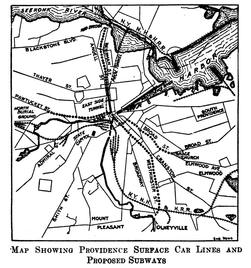
Visit the Flickr Page to see a larger version.
That’s a plan for a streetcar system with central subway for Providence from 1914. pdxcityscape writes on Flickr:
Proposed Providence Subway Map – 1914
Imagine Providence now if this was built…
Around the time that the East Side Streetcar (now Bus) Tunnel opened was a plan to expand it into a larger streetcar subway system in Providence running west to Olneyville, east to Red Bridge/Seekonk River, north to the North Burial Ground on North Main and south to Broad and Elmwood. The four subway branch lines would consolidate onto a single main trunk line between Dorrance and Benefit Streets, streetcar lines would run in the subway tunnels in the core then emerge outside downtown to finish their routes on the surface. The proposal went nowhere in 1914, it reemerged in the 1920s but again went nowhere, then because automania had taken over and the focus was on building new wide streets.
From ‘Engineering News’ March 19, 1914 (available on Google Books: search “Providence Subway Olneyville”)
WHY DIDN’T WE DO THAT!!!?


Well, I can tell you why they didn’t do it THEN – Lack of technology.
One of the many “Rhode Island Facts” I remember from my youth is that “Providence is the world’s widest bridge” – namely, all of downtown is technically a “bridge” having been built upon pilons. Well, in 1914 the ability to tunnel under that wide a water area wasn’t as tried and true as it was going under the English Channel and Boston Harbor later in the century. It existed, but it was way too cost prohibitive.
@Tom: If I’m not mistaken, the “world’s widest bridge” was the Crawford Street bridge that spanned from where the Citizens building is all the way down to the Rubik’s Cube. I thought that the only part of downtown on pylons is the part of Memorial Blvd right along the river.
Jef, It’s great that you found this. The proposed Providence Subway was referred to in Robert Fogelson’s book “Downtown – It’s Rise and Fall, 1880-1950,” but without any illustration.
As for tunneling under the river, other places have equally mushy and unstable soil conditions, i.e. the East Village and Williamburg where the L line subway tunnel is located and Hoboken and Jersey City were they tunneled for the PATH trains. Also Back Bay was previously a bay, which has subway tunnels (one of which is abandoned) and that neighborhood was created with land fill the same as Downtown Providence.
The most likely reason it didn’t get build is the lack of funding and the rise of the car.
Not only under the river, but throughout the downtown area, tunnels would be below sea level and the water table. Challenging to build, and high-maintenance.
From my memory of one of my history books, these go beyond mere proposals. If I remember correctly, there was federal money on the table and Providence was was the next major city in line to get a subway when the Depression hit. Plans had to be scrapped, and by the time the nation was ready to return to infrastructure projects, as Peter mentioned, America was hot ‘n’ heavy in love with the automobile.
Not to mention the teens brought an end to Providence’s historically high, double-digit population growth…
“Why didn’t we do that?” is a decent question but I think a better one is “What if we had?”
Can you image a high maintenance subway tunnel below sea level under the water table in downtown during the 70s and 80s? I was not here at those times but from what I have read and heard it included a lot of urban decay. The optimistic view is that we would have a nice little subway line running around Providence and some of the west side neighborhoods would be much better connected to downtown. The pessimistic view is that the whole thing would have cost a tremendous amount of money and gone the way of the east side railroad tunnel – abandonded, unused, and archaic. Don’t forget if it had been built in 1914 it would be nearly 100 years old now.
There are three images that I’m not able to find which would be related.
There was an illustration showing what a proposed underground station would look like under the East Side that was from 1910s.
There were two later subway proposals that were different by utilizing rail rights-of-way.
One from the late 50s showed a route starting in Bristol running along the current East Bay Bike Path route to the rail tunnel to Downtown and Olneyville then along the current Washington Secondary Bike Path to West Warwick.
The other was proposed in the late 60s or very early 70s before the second Washington Bridge was built. There was a proposal for a Bristol to Union Station subway, which would have been mostly at grade. It wasn’t planned to extend further west or south from Downtown. The Providence Journal had published a map of the proposed route at the time.
AF might be right about urban decay. Rochester disposed of a single-line subway system they had in the mid 1950s. On the other hand if a Providence Subway had been built, similar to Boston’s Green line tubes, it would have been more difficult for the PUC to allow the disposal of the trolley car system in the late 1940s because the investment in the tunnels. Nor would it be possible to run diesel buses through the four tunnels due to their length.
You know I had posted earlier that if we hadn’t gone to war in Iraq and Afghanistan we could have parceled out $2 Billion a year to each of the fifty states.
With that kind of money RI could have had a first class transit system.
The depression was certainly the biggest part of why this didn’t happen. The water table issues probably did have something to do with it also, but not in the most obvious way. Subways were being built under water and through fill before then anyhow. I’m willing to bet it was more about the flooding that occurred in 1938 and again in 1954 that put the final nail in the coffin. It makes no sense to build a subway in an unprotected area that periodically floods with seawater (to serve a city that fits in the palm of your hand anyway). It only takes one entrance in the flood zone to be overtopped to render the whole system inoperable, and even once the seawater is pumped out, all the infrastructure is useless. It would have to be gutted and totally rebuilt, at great expense and inconvenience. By the time anybody realized this, the federal government was ramming the interstate highway system down our throats anyway.
Parts of the New York system flood periodically. They’ve spent a few $100+ million to build numerous pump stations and occasionally have to replace segments of switching systems due to flood damage.
In spite of flooding concerns, if the subway had been built, Providence would have evolved differently with true rapid transit.
The subway planner’s really got it right with their proposal. Today several of the same corridors or destinations remain the highest used in the current bus system. It really is too bad that the subway didn’t get built. A positive takeaway from the rediscovery of the subway plan is that it could inform future extensions for the proposed Core Connector streetcar system.
Though a streetcar is not the same as a subway for speed, a streetcar system is far more convenient for users than a subway because there is no grade change to access it.
Strasbourg, France could be a model for Providence. Strasbourg is slightly larger in area and population than Providence, though its population density matches Providence.
Strasbourg has one of the most successful tram systems in the world. Similar to Providence, Strasbourg discarded its original trams in the 1950s in favor of buses. Strasbourg now has a six-line 35-mile system with 67 stations that covers the city. The first two lines became operable in 1994. Due to its immediate success, the city kept expanding the system to what it is today in less than 16 years.
http://en.wikipedia.org/wiki/File:Strasbourg_-_Straßenbahn_-_Netzplan.png
http://en.wikipedia.org/wiki/File:TramStrasbourg_lineA_HommeFer_versIllkirch.JPG
A subway for Providence?
DAVID BRUSSAT
January 10, 2002 Page: B-07
Section: Editorial Edition: All
“Downtown: Its Rise and Fall, 1880-1950,” by Robert M. Fogelson (2001), states: “Starting around the turn of the century and continuing until the onset of the Great Depression, advocates of rapid transit mounted campaigns to build subways in more than a dozen cities besides Boston and New York.
“A case in point … is Providence, Rhode Island, a city of only 225,000 in 1910. Responding to growing demands for rapid transit, the Providence city council hired B.J. Arnold in 1911 to make a study of the city’s transportation problems. Arnold reported that a subway was not warranted then or in the foreseeable future. The Providence Board of Trade and other commercial and civic organizations disagreed. Impressed by the success of the Boston subway, confident that Providence’s population would double and its ridership quadruple in the next two decades, they launched a campaign for a subway in 1913. A year later, on the basis of a favorable report by William W. Lewis, a civil engineer from Boston, the city council endorsed a proposed six-mile, $13.6 million subway, whose four lines all converged on downtown Providence.”
Fascinating book.
The earliest mention of a subway in The Journal’s archives is a Feb. 17, 1910, story headlined “To Banish Congestion With Subway System.” Strategies tried by other cities to reduce traffic jams, such as adding trolleys and doubledecking roads, were pooh-poohed. A study by the Committee on Railroads was proposed. Much of the story is given over to whether police and firemen should ride free.
Council passed a resolution supporting a subway on March 18, 1914. (By this time, Providence already had a subway, of sorts the tunnel from South Main Street to Thayer Street on College Hill, which opened in 1914 to serve electric trolleys; it now serves RIPTA buses.) The proposed subway had two lines crossing under Exchange Place. The east-west line linked up with the College Hill tunnel, which was designed not to ease traffic congestion but to ease the steep climb for trolleys.
(A longer tunnel, one mile under College Hill from Benefit Street behind the Providence Art Club to Gano near the Seekonk River, opened in 1908. It was not a subway but part of a railroad line to Bristol, which closed in 1937. Occasional freight trains used the tunnel until 1982. The final stretch of viaduct linking the tunnel to Union Station was demolished in 1988 as part of the Capital Center Project.)
After 1914, there is a gap in subway stories until 1925. An April 24, 1926, story described in the archive index reported that “Mayor Gainer regrets subway could not be included in new traffic plan by Whitten” (the city’s chief of planning). But the final subway story in the index, Jan. 12, 1927, reported: “Lewis outlines City subway plan, says tubes costing $17,000,000 would end surface trolleys.”
Did Whitten’s opposition kill the subway or did the Depression kill it? Either way, the city probably was better off without a (possibly very wet) subway, since its population failed to double, to put it mildly.
Fogelson, in “Downtown,” says that civic leaders believed that outlying retail hubs, which sprouted up as early as the 1910s, would strengthen downtowns by reducing congestion. When downtowns failed to fully rebound after the Depression, civic leaders panicked, and tried to reverse the trend with highways, then slum clearance, to no avail.
Providence was no exception. Plowing Route 95 through lower Southside deftly combined both dubious policies. A plan to “modernize” the look of down-town proved unaffordable. Fogelson doubts downtowns will regain their dominion, but he thinks the best strategy is luring citizens back downtown to live. At last, Providence is on the right track.
* * *
David Brussat is a member of The Journal’s editorial board. His e-mail is: dbrussat@projo.com.
Thanks for the back story David, you wrote that piece just before I moved to Providence, so I missed it.
http://www.bbc.co.uk/news/uk-16289051
What London is doing with a technology similar to the one we used here to create the combine sewage overflow system. While we were down there …