Facebook
Twitter
YouTube
Instagram
Home
About
In the News
Features
195 Relocation Project
Iway Podcasts
Metro Transit Study
Providence Parking Crisis Illustrated
Providence Yesterday
Reports
Links
Search
Home
About
In the News
Features
195 Relocation Project
Iway Podcasts
Metro Transit Study
Providence Parking Crisis Illustrated
Providence Yesterday
Reports
Links
Search
Search
Tag - Maps
Transportation
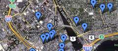
Build your own transit system with Transitmix
Jef Nickerson
June 20, 2014
Arts
1837 tactile map of Rhode Island for the blind
Jef Nickerson
August 1, 2012
News & Notes
News & Notes
Greater City Providence
November 11, 2011
News & Notes
News & Notes
Greater City Providence
September 12, 2011
Arts
Transportation
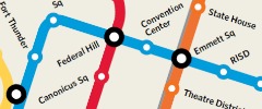
Crowdsourcing the Improbable Providence Subway Map
Jef Nickerson
August 3, 2011
Like/Dislike
Transportation
Greater Greater Washington Metro Map Contest
Jef Nickerson
May 25, 2011
Snow
Snow/Ice violations maps
Jef Nickerson
April 12, 2011
Bicycles
Roads
Weather
The Providence Pot Holes Project
Greater City Providence
February 7, 2011
Bicycles
Reader Submissions
Transportation
Rhode Island Bikeways Map
Jef Nickerson
January 27, 2011
RIPTA
Transportation
Sometimes, you get a map
Jef Nickerson
December 3, 2010
Economy
Where’d everyone go?
Greater City Providence
June 15, 2010
News & Notes
News & Notes
Greater City Providence
June 15, 2010
RIPTA
Transportation
Sometimes, you need a map
Jef Nickerson
February 22, 2010
RIPTA
Transportation
Better RIPTA maps
Jef Nickerson
February 3, 2009
Home
About
In the News
Features
195 Relocation Project
Iway Podcasts
Metro Transit Study
Providence Parking Crisis Illustrated
Providence Yesterday
Reports
Links