
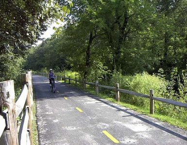
We have some spectacular bike paths here in Rhode Island, and two of them are about to get connected, maybe as soon as this spring.
Officials from the Broad Street Regeneration Initiative (BSRI) and the Blackstone Valley Tourism Council (BVTC) have announced that the City of Pawtucket, RI has been awarded $38 thousand in Federal funds to create a temporary on road connection linking the Blackstone Valley Bike Path and the East Bay Bike Path.
The funds come from the American Reinvestment and Recovery Act (ARRA) through the RI Office of Energy Resources and awarded to the City of Pawtucket.
This temporary on road linkage will provide bicyclists recreational and intermodal access to all the cities and towns located along both bikeways, along with guiding people who use both bike paths opportunities to access merchants and shops located along the Broad Street corridor of Pawtucket, Central Falls and Cumberland, RI.
Most recent projections indicate that the temporary on road linkage connecting the Blackstone Valley and East Bay Bike Paths should be installed by the spring of 2011.
More details on the temporary bikeway connections is available online at http://mybroadstreetri.com/bikestripe.htm
So, though it isn’t yet a dedicated off-roadway link between the two paths, it does sound as though it will be more than just “bicycles in road” signs.
McMahon Associates, a Taunton, MA based firm, was chosen for the project. They will be working with the committee to design the stripe and provide construction and engineering advice by early 2011. At that point, the committee will hire a painting contractor to install the stripe, ideally ensuring its completion for May 2011.


This is great news! I’ve been looking for a longer off-road bike path to ride. I just don’t like riding in the streets here because the drivers just don’t know what to do when they come upon a biker, especially in urban areas like Pawtucket. In fact, I have never ridden the entire Blackstone Valley bike path because it turns into an on-road bike “path” in Central Falls. Maybe it’ll be better if they stripe it out, but I don’t have high hopes for that.
As I recall, this is essentially a signage project, except that instead of signs, there will be a strip of paint running through the towns somewhere in the right lane or near the curb for people on bikes to follow. It is supposed to largely follow the route that has already been identified as the connector for EBBP and BVBP. It is certainly a step up from the non-signed connection now (unless one follows the East Coast Greenway Signs, which follows the same route).
I thought the East Coast Greenway led from the BVBP to the Washington Secondary path? Is it also signed to get to the East Bay?
I am 95% sure the East Bay Bike Path is not part of the East Coast Greenway.
View Larger Map
If this map embeds properly, you can see that the it runs through Providence from the Washington, across town to the top of the East Bay, then up through East Side and Pawtucket toward the Blackstone.
It actually doesn’t go into East Providence or over the Washington bridge. The East Bay Path starts at the Washington bridge and then goes south, but it’s not notated on the map (even when I click the link to view the actual map).
It is not signed per se, but since the spine of the ECG goes through India Point and that is the northernmost terminus of the EBBP, the route is already basically signed.
However, one thing to note, that implies taking Gano St., which was recently re-striped to allow cars to park on the western side (for god knows what reason), making an already narrow street even narrower and I would suggest not safe for riding – unless the striping is going to mean they turn that western side into a bike lane, although, again, riding on it a couple weeks ago, the stripe pattern suggested parking.
Also, since I’m on the subject, why in the name of the flying spaghetti monster should bikes be routed to avoid Wayland Square? I guess there is a nice view on River St., but unless someone builds a bike path along the river past Butler and Swan Point it is a waste of time to go that way when you then have to double back to get up to Blackstone.
Last, a major component of this route (Taft St. in Pawtucket) is already closed for the new I-95 bridge construction, and the easiest detour (Pleasant) will be closed the following year. This means the route will take you through the George/Division St. intersection, which is already a confusing mess of jersey barriers and clueless detoured drivers, or up division to the school/prospect st. intersection which is really painful on a bike due to the traffic backups and inability to switch to proper lanes, again due to the re-routed I-95 traffic.
Not that I am bitter that RI DOT essentially decided to let the existing bridge fall apart so they could do a much more expensive re-build while essentially shutting down Division St. for business just as the city was trying to revive it.
My mistake, Pleasant Street will be closed in January.
So, essentially, this project will not be able to connect the two paths for even a day until 2013, unless they are going to stripe the detours.
According to the state*, the East Bay Bike Path begins at India Point Park.
Of course, if and when the Washington Bridge Linear Park project ever gets back in the swing, it will be truncated again and detoured to the Henderson Bridge.
Brick, I think the dumb loop through along the water is because the Greenway is supposed to be a Greenway. It would of course be far better to sign it all the way to Angell/Waterman, where it would be ideal to have east/west bike lanes, that then connect to Blackstone Blvd.
The mess at the Pawtucket River Bridge, I only have one thing to say about at this time: sigh.
*Depending on what state resource you look at.
I would like to see better signage or a stripe for us commuters coming up the Cranston bike path. Huntington Avenue is a bear to cross and I would never want to send a kid through that light. Maybe a pedestrian bridge? Also, It would be nice if they striped us a lane right down Cranston St. rather than the suggested route along potholed, abandoned back streets. P.S. Cranston St. residents are awesome / gracious to cyclists.
As there have been so many comments regarding the East Coast Greenway, I should probably confirm/clear up some details. The map that Jef posted is indeed the current route of the ECG. The East Bay Bikepath is not part of the current travel route of the ECG, but has been identified as part of a potential alternate route from Providence to Boston (bypassing Worcester). The ECG is routed on River St rather than going through Wayland Sq for a few reasons: (1) scenic quality, (2) lower auto volume, and (3) it will be a more natural link to the future off-road trail currently planned to follow the river between Pitman St. and Gano St. (That trail will likely run off-road along the river from the Salvation Army bldg on Pitman to the 195 offramp at Gano opposite Trenton St.)
BTW, last I heard was that the stripe would not extend south of Pawtucket Town Landing. This is because a separate contract (this one to VHB) is leading to marking (in the spring, probably) of the on-road bike route from Town Landing to Richmond Sq (far eastern end of Waterman St, where Waterman Grille is). No need to duplicate the effort. The latter project will not paint a stripe on the road, but will consist of roadside signage as well as bike lanes on Alfred Stone Rd and perhaps one other street.
Thanks Eric!
Hi Eric,
Thanks for the clarification.
An honest question about what to do about Gano while waiting for the path?
The restriping has left no shoulder on the east side of the road, it is a long hill that anyone but riders in good shape will struggle to climb at faster than 10 mph, and there is a ton of traffic there most of the time.
I realize that going through IPP gives the rider another nice piece of scenery, but for inexperienced riders I think Gano is too dangerous, and at least uncomfortable.
I realize we are well off-topic and there are probably better places for me to talk about this. However this is near the front of my mind as Gano used to be one of my main routes and it was bad enough with the old striping. Now I use Governor or Ives and just suck up dealing with the 4 way stops.
Brick, I understand your concern. True, Governor and Ives have less traffic. Also true that Gano was more bike-friendly before the striping was re-aligned to create parking. But while I wouldn’t direct inexperienced cyclists (i.e., children) to use Gano south of Pitman, I think it serves well as a link between IPP and the Wayland Sq area for cyclists with some road savvy. I’d be happy to talk more about this with you at the free East Coast Greenway holiday party coming between xmas and new years. Look for an announcement shortly on ribike.org.
Well, at least they didn’t make it foolishly circuitous; they took the obvious route we all take already. Straight up Cranston St to the Citizens, left on Winter, then right onto Washington. Bang, you’re downtown. North Main is clearly the preferred route to Pawtucket, based simply on the number of cycles already on that street, so good on them again, there. (I prefer to go Charles / Randall and then No. Main, but I’m old and lazy.) Then North Main becomes Pawtucket Ave and takes you all the way to George. From there you’ve got options, but I make my point.
Am I the only person on this thing that actually rides a bicycle for transit? When Sunday recreationalists design commuter routes…? Well, commuters notice. And laugh.
Let me dust off my bike and carry it downstairs. [/pedestrian]
Sorry to be so late to the conversation. I am part of the team that has been putting this temporary bike connection together over what I am embarrassed to say has been a long period of time. As part of the planning process, we have included representatives of each municipality along the route and needless to say that means a wide range of opinions at each meeting.
The goal of the this project is to provide a temporary connection between the Blackstone Valley Bikeway and the East Bay Bike Path until a more permanent connection can be made. Engineers are currently working on the design of the connection, but it will conform to MUTCD standards – even though I think there are better options that do not.
I appreciate the concern about the route on Gano St. That piece concerns me as well. We will be sure to review that before any final decisions are made. Please feel free to contact me (andrewpierson@pawtucketcdc.com) if you have any questions regarding this connection.
I wonder if there’s a way to build an app for that.
Maybe put QR Codes on the signs that bring up a map showing the signed route, quickest route, amateur route…
Frymaster, the routes discussed here are not intended to be commuter routes, that’s why they don’t remotely resemble commuter routes. The “bike stripe” route is intended to be a recreation route, to link the East Bay and Blackstone paths. The ECG (which extends 2900+ miles from Maine to Florida) is a long-distance tourism route. If you’d like to see what city planning suggests for commuters, you can download the city bike route plan here:
http://bikeprovidence.org/wp-content/uploads/finalbikeprv3.pdf
A few comments on other comments:
@Jef, QR codes are a neat idea but leave behind those of us who can’t afford (and those who aren’t interested in paying for) expensive smart phones! Can urban transportation be designed so that it’s accessible to people of all income levels?
@Eric, that’s an exciting map of planned bike lanes! But do you know why almost none of the “phase 1” striped lanes have actually been painted? I’ve read elsewhere online (or maybe here too?) that Broadway was supposed to have been painted in spring/summer 2010, but that clearly hasn’t happened.
Chris, both are good questions. If you look closely at the map’s legend, you’ll note that the red lines of “phase 1” only note “bicycle routes”, not necessarily streets that will get bike lanes. Most of these routes are marked with bike route signs, without bike lanes striped onto the street. Your question about Broadway is timely, as just yesterday I got an email from city planning on that subject. For a full explanation, please see:
http://ribike.org/2010/12/21/whither-broadway
Just saw that this will be RI’s first use of “sharrows, those share-the-road markings.
Glad to see the use of sharrows along these routes, I think they are an excellent addition to the MUTCD and allow much more flexibility in adding “bicycle awareness” to a street, since bike lanes need standard dimensions, etc. Plus they just look cool. I have one tattooed on my leg.
Some of the streets being rebuilt in the 195 footprint are supposed to get sharrows as well (and the Point Street Bridge).