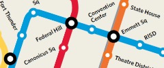

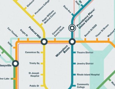
Shortly after that Robert Stewart, the creator of the Cape Cod and a collection of other small town improbable subway maps contacted me. He was looking to do slightly less improbable subway maps and wanted to start with Providence. After being waylayed a bit on the project, Robert now has a draft of his Providence subway map that he is working on finalizing.

Click image for larger more legible map
Not being from Providence himself, Robert has been relying on maps and interviews and the Google Machine to create his routes and name his stops. He is looking for us locals to let him know if he got it right.
Check out the map, and leave your thoughts in the comments for Robert. But do remember, this is not a literal map of a system that is actually, or will actually, ever be built. This is a fantasy, though Robert does want it to make geographic sense and some sort of sense of how service would run.
You can also find info about the map on its Facebook page.


Keep the Fort Thunder stop.
Looks good, but if there is to be a West Warwick subway line (which I think is neat but absolutely not likely), there should be a better connection to the airport (perhaps a connector line or shuttle from the mall stop to the airport stop).
Other than that, I think it’s awesome!
Love it! As long as we’re talking pipe dreams and we build the Orange Line out to West Kingston? I want to get rid of my car.
Looks great, maybe something like it might be built in a century.
Orange line – Change Chestnut Sq. to Jewelry District. Change State House to Providence Station or State House/Providence Station. and make the stop a transfer station for transfers to Amtrak, besides MBTA. What is Lovecraft?
Blue line – has two Gansett Avenues?
The Warren and Burr’s Hill Park stops should be merged into just a “Warren” stop. Burr’s Hill park is in Warren and the two stops would be minutes away on foot. It’s a very small town.
Eagle Square _and_ Fort Thunder?
I’d like to see a line going west from downtown along Westminster or Broadway down to Olneyville.
If I’m reading the map correctly, it seems to show the “Regional Rail Line” paralleling the subway (or vice versa) through the Theater and Jewelry Districts, past RI Hospital, and to the Zoo. This isn’t the way the Amtrak and MBCR actually run through town. That’s obvious to most of us, but either Mr. Stewart missed that, or a rerouted Amtrak line is part of the fantasy.
Love it, but this would be the slowest subway ever…at some places, I’d imagine the front of the train would have to begin to stop as the rear is just getting to speed. I guess I’m saying it seems like too many stops? But probably that’s not the point :^)
That aside, why only show the Seekonk and Providence Rivers? What about the mighty Woonasquatucket? The babbling Moshassuck?
It’s really exciting to see the names of the stops on a map, I can’t help but imagine the Providence that would emerge around this fantasy system…. I love it.
Wayland Square stop.
Can we build the blue line now?
Not because it is convenient or anything like that, but because it might stop the red bridge from being treated like it is part of an interstate.
Just a matter of logistics, the yellow line is nearly impossible to build over the bay given how deep (or high) you would have to go in order to keep the shipping lanes. If you move all shipping down to Quonset that might be a different story.
I wonder how much it would cost to build a system like that in RI. I figure about $6 billion or so. We can do it.
San Francisco’s 1.7-mile Central Subway project is estimated to cost $1.6 billion. The #7 extension in New York is one-mile and has one station is estimated to cost $1 billion. The full build out of the 8.5-mile Second Avenue subway with 16 stations is expected to cost $17 billion.
Robert Stewart’s shortest proposed line, the yellow from Rhode Island College to Wampanoag Trail is about 8 or 9 miles with 15 stations.
The 1914 six-mile long four-line Providence subway plan was estimated to cost $13.6 million in 1914 dollars, which if my calculations are right would roughly equal $300 million in 2010 dollars. They knew what the tunnels would cost at that time because they had built two of them just a few years earlier, the current trolley/bus tunnel between North Main and Thayer and the East Side Rail Tunnel between Benefit and Gano.
The current proposal for the two-mile long Core Connector surface streetcar line is estimated to cost between $75 and $85 million.
The time to build subways was in the late 19th and early 20th centuries, not today unless there’s a significant change in construction technology and labor costs and the elimination of the Environmental Impact Statement (EIS) process, which can add a third to a project’s cost.
Sorry to be a downer, but don’t count on a Providence Subway being built anytime soon. Rebuilding a streetcar system and fully developing commuter rail may be a more realistic goal.
While I know this is all a pipe dream, what’s the demand for a subway line that runs all the way to Bristol and West Warwick? You can cut these lines all really short if you keep it to Providence, Pawtucket, Central Falls, and the nearby areas of North Providence, East Providence, Johnston, Cranston, and Warwick. There’s no need for a subway outside of that area. Heck, I can see a subway/trolley thing like in Philadelphia. It would only go underground in the more dense areas (downtown, Olneyville, Federal Hill, and the northern parts of the south side) and then come above ground as part of the street outside of that.
@RunawayJim: Bristol, Barrington, Warren has a large commuter population to and from points north, i.e. Providence/Boston/Cape Cod.
Also, there is no other direct connection from the western mainland to the eastern bay islands other than to travel, by car or bus, down to Newport/North Kingston OR via I-95 / I-195. A central bay corridor would relieve congestion at either of those two current routes. Support from an extended line south to Newport would help to connect Providence and that city.
More alternative travel options, the better.
Side note:
Beyond cost, this project would be physically feasible. After all, the Narragansett Bay Commission Combined Sewer Overflow Tunnel is essentially the same construction type that would be necessary for such a project.
Folks often think Rhode Island can’t do big things and this largely unnoticed project has been taking place for sometime now and with great results, accolades and significance.
Phase I of the project was at a cost of $350 million.
http://www.jacobssf.com/index.php/industry_overview/view/61/
I suppose the “Johnson & Wales” stop is at the Harborside Campus? A bit confusing, considering that the main campus is downcity and right around the corner from the “Theatre District” stop. Also, I like changing “Chestnut Sq” to “Jewelry District”.
Andy, I don’t mean that they don’t need a commuter option, but a subway is not cost effective for the east bay. That’s part of the reason I propose a trolley/subway hybrid. In west Philly, they have streetcars that go underground and go high speed before entering Center City. They’re on the streets outside of Center City.
@Andy, you’re part right. It’s just that the sewer tunnel is only one tube. Two tubes are needed for a subway (two directions). So costs would be double, plus if three or four stations per mile were added, even if the price were a lower, the price tag would near a billion per mile.
Subway costs:
1914 = $50 million per mile (in current dollars), PVD
2011 = $1 to 2 billion per mile (in current dollars), NYC, SF
Subways are not practical today, although there’s an abandoned mile-long two-track tunnel under the East Side worth about a $1 billion that should be reused for mass transit. In specific circumstances tunnels could be built for mass transit, just not an entire system.
Robert Stewart’s map may have less to do with subways and more to do with high-speed mass transit. Subways alone are not the only way to achieve high-speed mass transit.
Actual BRT (Bus Rapid Transit), Light Rail, and Light Monorail can achieve high-speed mass transit at a fraction of the cost of heavy rail subways, surface, or elevated trains.
http://www.gcpvd.org/2010/09/17/why-a-monorail-is-better-than-a-streetcar/
The East Bay Corridor from the East Side to Newport is a good example. The corridor has about 200,000 people, who could access a mass transit line by foot, bicycle, local shuttles, or private cars/park-and-rides. Commuter traffic could be dramatically reduced. Hotels and convention facilities in Providence and Newport would all benefit. Tourism in the East Bay towns would benefit as well.
If there isn’t a wide enough surface right-of-way for BRT or light rail along the length of the East Bay corridor another option might be utilizing automated light monorail technology from the East Side Rail Tunnel to the East Bay Bike Path right right-of-way, and beyond to or above the Aquidneck rail line. A silent rubber wheeled electric monorail vehicle could glide above the bikeway. BRT and light rail may have better applications in other transit corridors throughout the metro area and state.
The key for successful mass transit is that it must provide high-speed, high-frequency service (ideally around the clock), and offer the greatest possible connectivity between locations. Daily operational costs is an issue. Automation or eliminating the driver/operator is one way to reduce costs.
With a dysfunctional federal government and a state government that’s broke and hijacked by car culture, Robert’s map and related discussions like this one can help to raise awareness of the importance of mass transit.
How can a culture where the majority of the population uses mass transit be reestablished in Rhode Island?
Probably not with a monorail, sorry.
I’d change the “Willet” stop (which is misspelled anyway) to Peck Corner. Sounds more illustrative…
Thanks so much for the feedback, everyone. We’re going to incorporate into our edits and get a new draft up soon!
The DC Metro is a series of singular tubes, not two. If you look at the picture in the link below of the sewer tunnel, you should noticed a freight train in the tunnel.
Importing a level platform 1/4 or 1/3 of the up from the tunnel floor would allow for two trains passing.
The second link is an image of the DC Metro to compare.
However, I agree with Peter and Runaway Jim, respectively, that subways are probably not the way to go and that mixed rail and trolly are more probable. Especially considering the type of bedrock that exists under most of Rhode Island.
I have often dreamt of future highway/free way usage.
Understandably so, there is a lot of unused land amongst our highway acreage, in part do to safety and infrastructure challenges. However, I’ve never quite understood why do we not take advantage of its vertical real-estate to either allow for monorail, building or even wind-turbine opportunities?
Area of opportunity that come to mind for buildings or wind-turbine: Rt. 6/95 Interchange with monorail/sub transit along all major routes.
RI Sewer Overflow Tunnel: http://www.jacobssf.com/images/uploads/NBC_6.jpg
Washington D.C. Metro:
http://www.publicdomainpictures.net/pictures/1000/nahled/127-1205472106WiEV.jpg
Hey Robert,
Sorry to be a Johnny come lately! Hopefully you’ll find my comments interesting, at the very least.
I think your map (and the idea in general) is awesome. It may be that none of it will ever come, but it does (and really already has, given the above comments) get a conversation going about rail rapid transit in Providence, which I think is imperative.
I actually engaged in a similar project (design a transit system for Providence, though I tried to make mine realistic and sellable) a few years ago, just for my own enjoyment, so I have a few thoughts for you, mainly on your Blue Line on the East Side…
-I would rename “RISD” to “South Main Street” or “Benefit Street” (assuming that’s where the station is); if the stop is much closer to Thayer Street than that, I would consider eliminating it for being too close.
-Also be careful with the name “Thayer Street/Brown” because there is a Brown Street that runs parallel to Thayer, but never actually intersects; hypothetically, people might misinterpret “Thayer Street/Brown” to mean the non-existent intersection of Brown and Thayer Streets. Besides, most locals would associate Thayer Street with Brown University anyway.
-Depending on the actual routing of the Blue Line (I don’t know if you have that deliberately planned out), I would add a stop somewhere on the eastern edge of the East Side, at Gano Street, or Butler Avenue (near Eastside Marketplace) or Wayland Square.
-Re the Orange Line: I would rename “State House” to “Providence [Union] Station” or possibly “Providence Place Mall/Union Station,” again, depending on the actual location of the station. Those three landmarks really are all very close to each other. In my ideal world, regional service stops only at Union Station and local trains/subways would stop at both Union Station and PPM, since the Amtrak ROW runs right underneath the mall, perfect for a subway station.
-Lastly, the current, and somewhat infamous, transit hub in Downcity Providence is Kennedy Plaza, not far from where I believe Emmett Square is (although I’m not sure about that). A fair bit of money has been put into Kennedy Plaza as of late. Kennedy Plaza is in the rectangle created by Exchange, Washington, Fulton and Dorrance Streets. Imho, you’d be better off putting the transfer station at Kennedy Plaza, and not Emmett Square, since I believe the latter is also very close to the Convention Center (which should almost definitely get its own stop).
Also echoing the comment made above about Regional Rail service. It doesn’t quite line up with the existing Amtrak/MBCR ROW. Also, RIDOT is seriously looking at running commuter rail service to Worcester, so you might consider adding that to your map.
Again, I think what you’re doing is really cool. Hope my comments have been somewhat helpful!
Best,
Will Palmer
P.S. Be sure to check out Andrew Lynch’s futurembta.com and vanshnookenraggen.com (FutureNYCSubway series)!
This is essential if we want RI to move into the 21st century. I hope your dream happens. Please make sure you keep in mind some of the comments made. Getting to connection points is one of our biggest issues. Love the idea of using train routes that are no longer in use. We shouldn’t have to own a car to get around in such a small state.