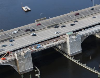
RIDOT is prepared to start work on the long awaited Washington Bridge Linear Park. The park is set to be built on remaining sections of the old Washington Bridge and will connect pedestrians and cyclists from Providence’s India Point Park to the East Bay Bike Path in East Providence.
As a result of work, the current passage over the bridge will be closed starting Monday, July 19th. RIDOT recommends recreational users of the East Bay Bike Path head to park in East Providence. Others are urged to use RIPTA to get to/from East Providence. RIDOT recommends that only “experienced cyclists” use the Henderson Bridge to cross the Seekonk River. Says a lot about RIDOT’s bikelanes on that bridge, don’t you think?
Full information about detours and closures can be found on RIDOT’s website.
The Rhode Island Department of Transportation (RIDOT) announced that it is starting the construction of a new linear park and bikeway over the old Washington Bridge between Providence and East Providence. Due to the construction, the Department must close the portion of the East Bay Bike Path that crosses the old Washington Bridge on Monday, July 9, 2012. This section of the bike path will be closed for approximately two years.
During the closure, experienced cyclists who commute to work by bike may use the Henderson Bridge to cross the Seekonk River. No formal bike path detour will be established.
Cyclists also may make use of RIPTA’s Rack ‘n Ride service, which is available on all regular buses. For no additional charge beyond the normal fare, cyclists can load their bikes on racks mounted on the front of RIPTA buses. RIPTA’s 33, 34 and 60 bus routes utilize I-195 and the Washington Bridge, while Buses 32, 35 and 78 provide service over the Henderson Bridge.
Maps showing local roads and bus routes will be posted at kiosks at each end of the closed bikeway. The maps and more information will be posted on RIDOT’s website at www.dot.ri.gov/bikeri.
“Given the popularity of the East Bay Bike Path, we know this closure will inconvenience some cyclists, especially those who bike to work,” RIDOT Director Michael P. Lewis said. “When construction is done, however, cyclists will have a vastly different experience riding into Providence. We eagerly await the reopening of this bridge as not only a first-class bikeway, but as a new park and destination for the city.”
Like the reconstruction of the India Point Park Pedestrian Bridge as part of the Iway project in 2008, this project will replace a sub-standard bridge for cyclists and pedestrians. The current crossing is so narrow that when cyclists approach one another from opposite directions, one must stop to let the other pass safely.
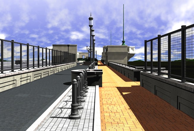
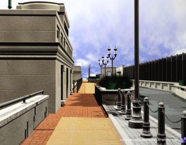
Through a $22 million contract, RIDOT will rebuild the remaining section of the original Washington Bridge that carries the existing bikeway and a section of the original highway bridge. In the same footprint will be a much wider bikeway and linear park. It will feature a separate bikeway and walking path, scenic overlooks, park benches, flag poles, decorative lighting and landscaped planters. The project also calls for restoration of the historic, multi-arch granite façade of the Washington Bridge and two operator’s houses from which an original drawbridge was controlled.
When opened, the new linear park will be named the George Redman Linear Park, after the East Providence resident who was instrumental in making the East Bay Bike Path a reality 25 years ago. Redman continues to advocate for bike path development across the state.
RIDOT also will reconstruct the Warren Avenue Ramp Bridge, which carries off-ramp traffic from I-195 East to Veterans Memorial Parkway (Exit 4) as part of this project. This ramp is scheduled to close in Fall 2012 and reopen in late Summer 2013.
Those with questions can contact RIDOT’s Customer Service office at 401-222-2450 weekdays from 7:30 a.m. to 4 p.m. Additional information will be available on RIDOT’s social media sites on Twitter and Facebook.
Also see RIDOT’s interactive presentation of the Linear Park.


“Says a lot about RIDOT’s bikelanes on that bridge, don’t you think?”
I think it says more to the poor physical condition of that bridge, more than anything. The pavement is crumbling and the expansion joints are down right dangerous. Does RIDOT have any plans in the pipeline to repair the “highway to nowhere” ?
“During the closure, experienced cyclists who commute to work by bike may use the Henderson Bridge to cross the Seekonk River. No formal bike path detour will be established.”
Let me reword that.
“during the closure, only cyclists experienced with using sub-par bicycle infrastructure should use the Henderson Bridge. Additionally, because we refuse to clean the bike lanes, cyclists should be sure to use puncture-resistant tires, because the ‘bike lanes’ are covered in broken glass, nails, brake rotors and other debris. No formal detour will be provided because we don’t really care about people who use bikes for transportation.”
Also, I can’t remember an occasion when RIDOT warned that only “experienced motorist” should use a given roadway.
i wonder why this is going to take two years.
Pretty sure they only put bike lanes on the Henderson to get access to additional federal funds. Adding signs and moving the line eight inches is not a bike lane.
The condition of RI bike lanes has hugely increased my respect for the advances in tire technology in the last decade. I marvel daily at the crap I’m riding on without flatting.
There is so much glass that it’s hard not to take it personally. On residential streets I chalk some of it up to bungled recycling, but in a bike lane in the middle of a bridge?
Small consolation to many, I’m sure, but RIDOT reports that the Henderson Bridge bike lanes will be swept twice weekly during the Washington Bridge closure. I’m assuming this does not include winter months, as RIDOT’s street sweepers are mothballed during that part of the year. Perhaps they can be persuaded to do the same for Allen’s Ave, and for beyond this two-year period.
Too bad that they couldn’t have phased the work to keep even a single bike lane open during the two years. They always manage to narrow and shift car travel lanes with highway construction.
I think what RIDOT is saying (about the Henderson Bridge ) is that on road bike lanes are not really meant for recreational use.
You’ll get over it.
The 1980s called and they want their faux historic bollards and ugly brick back …
Agreed, dated. A missed opportunity to do something great like the High Line. It was the design team that they chose. For many projects around the state the same names keep coming up and the results are mediocre.
This project has been such a long time coming, it may well have been designed in the 80s.
It’s boring, and it’s low maintenance, but the current state is so bad I actually liked what I saw.
It looks like they could have built it while keeping the existing 3 foot lane open and then lay the beautiful bricks on that side when the new side was ready. But hey, it’s only a bike route.
I’m sorry but it seems that many people are missing one very important factor here. Though it will take awhile; we are getting a much nicer and safer way to get across the river. Yes the Henderson is not ideal as a detour but it will work. As it stands, the Washington is nerve racking at best and downright dangerous at worst. It just goes to show that a governing body will always receive criticism no matter what it does; I, for one, welcome any improvement over what is in place now.
@Coy – I have read very little disagreement about the new facility being constructed being a good thing. We could wish that it were constructed more like a normal road with work occuring on alternate sides, but it is understandable that such a plan would increase cost and possibly delay the project further.
What is objectionable is that RIDOT has decided that they cannot sign a detour, provide adequate notification prior to the closure, or provide more useful information about other alternatives. If a bridge across a river is out in other circumstances, you can bet there will be construction signs and detour signs for how to navigate around the disruption in the road network.
RIDOT has already set precedent for providing bicycle detour signs on the last maintenance of the Henderson bridge when the roadway was narrowed and during the current Pawtucket River Bridge construction. Why is this project not worthy of that treatment?. 200 people per day on a weekday is in my mind a pretty significant impact, especially as the RIDOT suggestion is to go from what was a free crossing on an independent schedule to using RIPTA, which would cost at least $2 each way and the buses schedule and route. Add to that the RIDOT map doesn’t indicate WHERE the nearest bus stops are for which routes. When one is standing at the bridge suddenly facing a fence, what should they do?
Also, when the Union Avenue bridge was closed, the pedestrian detour consisted of free RIPTA buses.
@Matt @Jeff – I absolutely agree with what both of you have said. I only meant to point out that; (not necessarily from here) I have experienced far more negativity about the inconveniences of the project than positive regard for the effects of the outcome.
It’s not online yet, but there’s an article on the front page of today’s Providence Journal “Ultimate deraileur” by Richard Salit that discusses the bikeway/pedestrian bridge closure. The closure, the lack of detour signs, or not allowing a temporary right-of-way for cyclists on the bridge itself is nonsense. This seems to be more about RIDOT attempting to avoid liability for any bad decisions it may make regarding cyclist safety.
Possible solutions:
1. Erect scaffold for the full length of the bridge over the current bike lane, while the new bike lanes are under construction on the north side. When the new bike lanes are complete, move the scaffold over the new lanes so that the remainder of the pedestrian bridge on the south side can be finished.
2. If the bridge is to remain closed, post detailed signage on both the East Providence and Providence sides of the Washington Bridge bike entrances with a map showing a designated route to the Henderson bridge and showing where the nearest bus stops are located for those who chose to take the bus across the Seekonk River instead. RIPTA buses should be free from designated bus stops.
3. In both directions from the Washington Bridge to the Henderson Bridge, install detour signs directing cyclists to the safest route. Where it becomes complicated to traverse the Henderson Bridge ramps on the East Providence side, reduce the ramp widths and create a bike lane using Jersey barriers. Jersey barriers (concrete or water-filled plastic) or cones, and detour signs should be posted on the Henderson Bridge and its approaches.
Do we have to wait for the first bike fatality before RIDOT takes any responsible action?
Well, its almost done. Cant wait to use the new bridge !
Except it’s not: http://www.providencejournal.com/news/environment/20141112-opening-of-washington-bridge-bike-path-in-providence-delayed.ece
My friend and I walked across the new “linear park” today. It’s almost completely finished with almost all of the elements in place. My thoughts are that it’s not really a park, but it is an excellent bridge. It’s too close to the constant rush of the highway to be a pleasant stroll, but it is a great bikeway and bridge.
I really find the design direction to be well matched with the existing historic bridge. In a few years it will be difficult to discern which parts are original and which parts are new. In some ways the whole project reads as a simply a restoration of the existing bridge. It’s a very architecturally sensitive addition to the bridge.
I don’t think comparing it to the highline is very appropriate. The two projects serve totally different purposes and have vastly different environmental conditions.
My only criticism is the noise and constant rush of cars. It’s really not a fun place to walk thanks to its proximity to the highway. The old pedestrian path was about 30 ft. or so away from the highway. The new path is about 10 ft. away, a consequence of the wider bike lanes and sidewalks. A simple solution to this problem could be a taller wall along the highway. Some simple precast panels would do the trick.
I fear without a taller highway wall it’s never going to be a pleasant place to walk and hang out, but it’s still great bikeway.
I wonder what a serviceable bike-ped bridge would have cost, how long ago it would have been completed, and how much $ would have been left over to spend on a “Park” somewhere that might feature the park-like quality of every part of it not being 10 feet away from 10 lanes of roaring traffic.