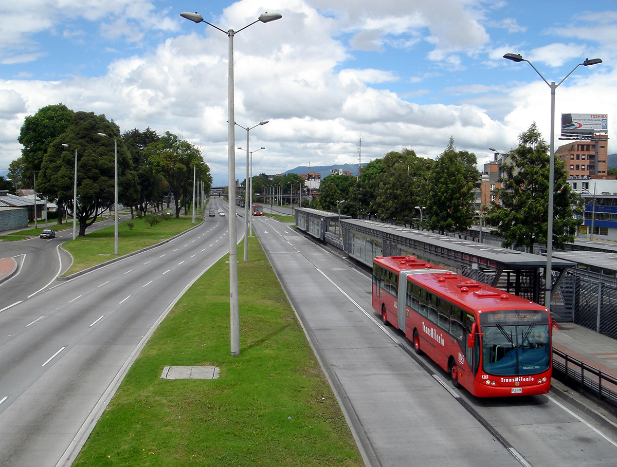
TransMilenio – Heroes station in Bogotá, Colombia. Photo (cc) Jorge Láscar
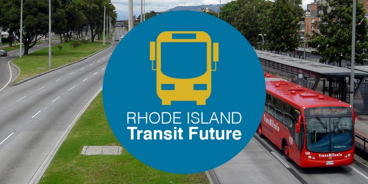
[alert type=”warning”]This post was submitted Greater City Providence reader Peter Brassard. If you’ve written something you’d like us to consider posting, please contact us and let us know.[/alert] [alert type=”info”]The Coalition for Transportation Choices (CTC) with the collaboration and assistance of Grow Smart RI will present on Tuesday, December 1st NEXT STOP: Making Transit Work for Rhode Island, a forum for business, civic and political leaders—together with transit riders.The following is the first of a series of articles meant to encourage thought and discussion on Rhode Island mass transit issues. I will try to offer perspective on several transit modes, as well as suggest potential strategies for improving transit in the state. I urge others to put their own ideas forward and to comment and improve upon mine.[/alert]
 The primary issues for Rhode Island mass transit are:
- Travel times
- Frequency of service
- Negative cultural perception of transit
- Limited funding
The first topic, which follows, is on BRT (Bus Rapid Transit).
BRT is the use of buses using mostly exclusive right-of-ways to increase travel speed and reduce delays. The system features stations with platforms. Fare payment occurs within the station or elsewhere, but not on the bus. Generally, when a bus enters a station, multiple doors open to speed up the boarding process for passengers exiting or entering.
The state is interested in exploring the possibility of incorporating BRT routes as a part of the Olneyville Expressway replacement. Others, as well as myself, have suggested downgrading the highway(s) to a boulevard, similar to what has been done with the West Side Highway in New York and the Presidio in San Francisco.
Whether the road is rebuilt as a highway or boulevard the same questions come up, when BRT is considered as a part of the road replacement.
- Where will dedicated bus lanes be located?
- Will there be just one or multiple routes?
- Where will stations or platforms be located?
- How many cars will be able to park at Park and Ride lots?
- Where is the population coming from that would use the BRT?
BRT Lanes:
Exclusive BRT lanes can be located on the extreme right or left side of the road. There are different advantages to both.
When lanes are on the left side of the road, only a single center platform is necessary, as is done in Bogotá, Columbia with its TransMilenio. The Bogotá configuration requires a special fleet of buses because doors must open on the left side for the center platform.
Bogotá as well as Curitiba, Brazil use high-platform buses, which is not as necessary today with newer low-floor bus design.
Connecticut’s Fastrack BRT uses platforms on the right side of the road, so they can mix conventional buses with Fastrack BRT buses. At a few Fastrack stations buses get off the road and donut around station platforms at Park and Ride lots, but still use the right side bus doors.
Besides equipment limitations with left side BRT lanes, an advantage is that the left BRT lane can be also used as an express lane for cars. The lane could be used as a High-Occupancy Vehicle (HOV) lane requiring a minimum of 2+ passengers.
In light of the current toll discussion and a need to find additional funding for road and bridge repairs, another approach for using the special express lane could be to charge for its use—an E-Z Pass lane. This would be a voluntary toll for faster travel. Drivers would be able to continue using the road for free, but only in the right lanes. Among other places there are examples of E-Z Pass lanes in use in the DC area and California.
Where E-Z Pass lanes or HOV lanes are most needed are Routes I-95 (between Rt. 4 and Pawtucket), the length of Rhode Island I-195 and the 6/10 Connector east of Olneyville, but not as much on Rt. 6 and Rt. 10 beyond the Olneyville Square area where much of the BRT lanes would likely be built.
The BRT right lane alternative would most likely preclude an E-Z Pass or HOV lane for cars, but the advantage would be that BRT buses could mix with RIPTA’s conventional bus fleet using the same dedicated transit right-of-way. Stations could be simpler.
In the following map, I’m suggesting two BRT routes, one following Route 10 from Park Avenue in Cranston and another from the Route 295 and 6 interchange in Johnston. Both routes would terminate at Kennedy Plaza (or Burnside Park).
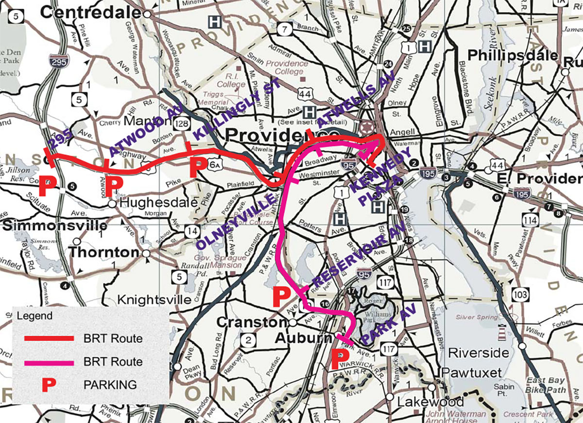
Base Map: 2011 State of Rhode Island Highway Map
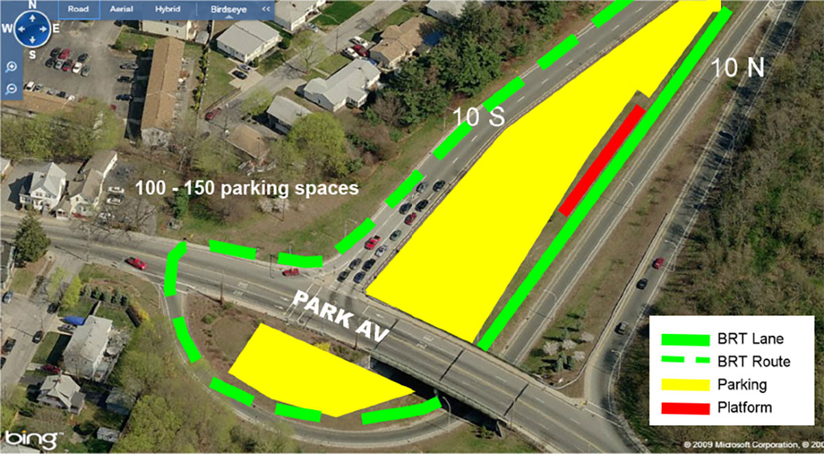
In this plan Park Avenue, Reservoir Avenue, I-295, Atwood Avenue, and Killingly Street would have Park and Ride parking lots. There would be no special parking provided between Olneyville and Kennedy Plaza.
Base Maps: Bing Maps
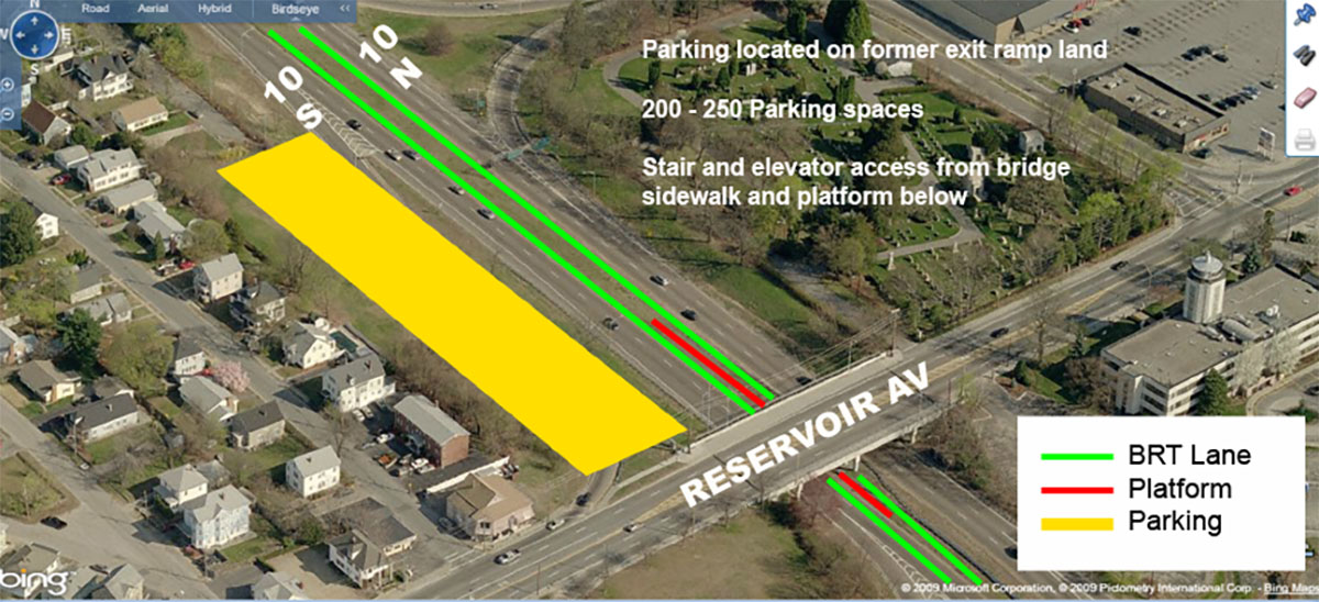
Reservoir Avenue presents a great opportunity for a Park and Ride using the land of a recently abandoned exit ramp. Rt. 10 has the width for additional two left lanes plus a smaller median. The spacing might be tight to provide two BRT lanes and a center platform with an elevator and stairs leading down from the sidewalk of Reservoir Avenue. Even with the constraints of the overpass it may be possible to squeeze the car travel lanes slightly right to allow enough room for a station.
It would be easier to build stations at Atwood Avenue and Killingly Street, since the existing left travel lane could be converted into an exclusive BRT lane. The existing wider median has more room for a center platform. At I-295 the BRT bus could loop around from westbound to eastbound under the overpasses. It’s possible to park 200-300 cars in the center median area.
The big question is who would be using this BRT bus service along these two routes? The suburbs west of 295 are not densely populated. The likely catchment area would mostly be from Smithfield, Johnston, and western Cranston. For Cranston residents near Park Avenue would it be worth parking to take the BRT or just drive into the city?
The BRT could become popular as a way to avoid paying for parking in Downtown Providence, but Park and Ride lots would have to be free or near free. Without major anchor or hub destinations at Park Avenue and Route 295, would the BRT only be used heavily around the rush hours and less so at other times? How would parking be expanded?
If the state goes forward with a BRT plan for the 6-10, then marketing the system, as with other transit branding, is as important as providing the service. The BRT could be called PRO-BUS. PRO-BUS can be read in several ways, PRO for Providence, PRO for progressive transportation, or PRO for professional bus. There are certainly other interpretations.

I’d like to see us focus on housing development near the BRT rather than park & rides, and increase bike infrastructure and walking connections. I have a hard time imagining people park & riding to a degree that would be justified, and the park & rides we have elsewhere in the state are extremely poorly designed so as to basically be outposts in the middle of unwalkable strip malls on highways. Maybe park & rides would be fine far out in the exurban extensions of this project, but there shouldn’t be any in Providence.
I also kind of think BRT is a zero-sum proposition based on whether there’s a boulevard or not. Building a BRT route as an express Cranston route on the highway seems like a complete waste, whereas building a BRT route on a boulevard would be a huge step forward.
I hope people will follow @movetogetherpvd on Twitter for more.
I agree that to build ridership on BRT the State should focus on Transit Oriented Development (TOD) on State owned land.
The example of the land freed up by the reorientation of the ramps at Reservoir Avenue are a good example of where TOD could occur on State land. That area would be all the more attractive if Route 10 were turned into a boulevard rather than its existing highway form.
Reservoir south of Route 10 is frankly a TOD wasteland, no one wants to be walking or biking there (that could be fixed over time). Reservoir north of Route 10 is of course Providence and a much better TOD environment. The strip mall on the Providence side of Route 10 could be better tenanted with neighborhood services retail (such as a small grocer) and the TOD development itself on the former highway land could (and should) be mixed use with neighborhood services.
The southern branch of the BRT line would be more effective I think if it could be configured to reach the MBTA station at the Airport (as true BRT the entire way). Park & Ride I think would only be appropriate at Route 295, the Airport (where it exists currently), and perhaps a BRT stop at Route 37.
The BRT extended south would serve further TOD in Cranston and Warwick, utilizing City and State land would yield income for those governments that free Park & Ride would not.
All those Cranston/South Side highway-stroads (Reservoir, Park, Elmwood, Broad) could easily get protected bike lanes. So wide!
In some cases I think biking proceeds walking for successful TOD, because of sheer distance. It doesn’t take much more than some adequate PBLs to make a biking environment, but walking (at least when I do it) is something I choose in only the nicest of environments. I think it’ll take longer.
This certainly is appropriate as is the potential approach regarding the West End connector.
What troubles me is the constant reference to Rhode Island mass transit”. Until the political leaders, planners, and citizens of the city, state, and larger metro area absorb the fact that transit is not a state dynamic, the conceptual framework for transit solutions will be insufficient.
Metro areas produce the ebb and flow for mass and vehicle movement – not states. Providence and its metro area (all of RI and southeastern MA) drive volume, habits, and needs for mass transit.
Providence is the core of a 1.6 million person metro, center of some of the most dense and high volume train, vehicle, and residential population sites in the nation…a perfect model for mass transit improvement.
But, it will not occur until our frame of reference changes.
When we discuss, reflect on, and plan for mass transit (train, streetcar/subway, air, bus), the focus must be on Providence – and more broadly, the Providence Metro — not Rhode Island.
The problem with this plan is that this is not where the transit ridership is. It’s fine to make such a compromise if there’s a rail ROW, but if it’s a bus, use the streets where the busiest buses are, i.e. Broad and Main.
Deciding if a BRT route should go on a transit boulevard or a dedicated BRT lane on the highway is a tough decision. if the 6/10 connector is torn down, it’s a very easy decision. but as it stands now, it’s whether you want the BRT to be a catalyst for TOD or the most efficient route possible. The Cranston and Warwick areas are in dire need of TOD. 100 years ago, Cranston and Warwick had centralized walkable urban cores. Cranston has a higher chance of regaining its walkability but Warwick has some potential, especially if headways for the commuter rail are increased at the interlink station. I feel like RIPTA and SRTA should merge. Transit connections to southeast Massachusetts from RI are literally non-existent. At least BRT to the Fall Fiver and New Bedford area from Providence should be a high priority.
What you actually want is headways to be reduced, increased headways mean trains are further apart, you have to wait longer between trains.
Yeah I meant lower headways. Doesn’t the commuter rail come to the interlink station less than 5 times a day? Know wonder the ridership is so low at that station.
Just checked the MBTA website and the headways are on average 2 hours at the interlink. That’s still way too long.
As Mark suggested, the RIPTA and SRTA should be merged into the PMTA (Providence Metro Transit Authority) so the entire metro can be served by a planning regime that makes sense.
Providence and its metro area (all of RI and southeastern MA) drive volume, habits, and needs for mass transit…the delivery system should reflect that.
10 roundtrips per weekday for CR at the InterLink.
David,
Did you consider Wellington Ave as an alternative to Park Ave for the southern terminus of a Rt 10 BRT route? Years ago, Cranston began expressing an interest in an Amtrak stop in that area, along with the possible reuse of some of the old mills in that area as a mixed use center.
Sorry about the gibberish there. Copied and pasted it somehow. It’s from an article I was reading the other day. That’s a lil TOO big picture, I think.
If that idea is any good, then I also think the Pawtuxet could then be bridged at Wellington to provide a bus-only shortcut over to Jefferson Blvd, which could then be reconfigured with a bus-only lane to get a BRT connection to Amtrak and the airport.
There are 2 kinds of people.
1. Those who can not imagine that anyone would leave their house to go anywhere, ever, and not invariably prefer to go by car.
2. Those who are interested in getting around on foot, transit or bike, some or all of the time.
Can we, once and for all, forget about trying to entice “Choice Riders” out of camp #1? Most people, especially those who have chosen to live in the suburbs, are perfectly happy with the world we spent the last 3 generations building. Sure people complain, but traffic and driving hassles are relatively minor around here. Can we learn anything from the Wickford Junction boondoggle?
What can we do for people in camp #2? Providence and the inner suburbs are largely comprised of neighborhoods that are, on paper, dense enough to allow at least some people to maintain car-free or car-lite habits, yet practically everyone who is not poor still drives everywhere they go. Real estate ads in Providence tell you it is “walkable” but in reality, whether you are poor or not, you have to be a bit of a crank about this car-free business to settle here and not quickly conclude that life is a lot easier with a car, even in the most promisingly citified neighborhoods. Fixing the problems that make this so just might transform this city. Coaxing a few commuters into parking shuttles has nothing to do with it.
Thank you, Andrew! I’ve been thinking the same thing (especially in light of the most recent post in this series about late night service). Let’s improve transit in the city before we get too far ahead of ourselves. It’s nice to think that people in the suburbs might want service, but I’m guessing the ones who would like to use RIPTA already do. Sure, it can be improved for them, but there are plenty of people here in the city (me, me, me) who would like to use it more often yet don’t because it doesn’t suit our needs in even the slightest way. I’d love to see more pie-in-the-sky ideas for the city and immediate surroundings.
I like drawing transit lines on a map as much as the next transit advocate (heck, I’ve drawn a BRT plan for Providence like 20 times!), but I believe that for PVD and its metro area, bringing our traditional bus service into the 21st century is a much greater goal. Increased frequency, proof-of-payment fare collection, travel-distance based fares, and moderately increased spacing of bus stops would give us a much higher quality bus service able to serve far more riders and be more financially self-sustaining.
One essential component of BRT (or, in fact any bus service) is real time tracking of bus locations via mobile phone. Hell, if Albuquerque, NM can provide this for their riders (which they do), surely RIPTA can as well.
@Andrew I @Runaway Jim
Re: Night Routes
Woonsocket, Newport, the town downtowns, and villages, most of which are densely built with multifamily buildings (urban), wouldn’t be characterized as typical suburban. URI and RWU may be in suburban or rural areas, but I wouldn’t consider them suburban places either.
If you study the statewide map, you’ll see that I made an effort to have the routes reach as many of those walkable urban places as possible.
Besides the two cities, places include Manville, Valley Falls, Centerdale, Arctic, Phoenix, Wakefield, Narragansett Pier, Wickford, Downtown East G, Downtown Warren, Downtown Bristol to name a few.
I started with the urban core map. Why I chose to include a state map is because Rhode Island municipalities are Balkanized. If you don’t include most of the state, you won’t get support to do much.
If we could implement something similar to what Bogota has for a BRT (real-time data, off-bus fare purchasing, spaced out stops, real stations, and everything else others have mentioned), then that would be a pretty great public transit system for Providence, in my opinion. This *can’t* be the Silver Line in Boston – that’s not BRT.
However, I think what would be missing from that is the return on investment that rails get you. I think it’s been proven multiple times in this country that true rail transit in cities has a much bigger ROI than buses do.
So what’s our city’s goal? Great transit or great transit + investment?
The is a great beginning. Lots of important input here, and I hope RIDOT listens carefully.
I would like to see Multi-modal/BRT implemented with a mix of pedestrian oriented boulevard planning and dense development proposals -actually doing both housing and transit in tandem order all along both corridor(s). Meanwhile, lets de-emphasize parking near Olneyville -keep that closer to the 295 beltway. Above all, interested citizens should get out to nearby Hartford to try its new CTFastrack BRT service to New Britain. This recently opened project is a big success for Connecticut and a great precedent for Rhode Island!
In response to Steve, instead of calling the Providence Metro Transportation Authority or my suggest name the Metropolitan Rhode Island & Bristol County Massachusetts District Commission or Transportation District to call it the Metropolitan Providence Transportation District.
This would involve a joint management of the Rhode Island & Massachusetts Departments of Transportation, Rhode Island Public Transit Authority, Greater Attleboro & Taunton Regional Transit Authority & Southeastern Regional Transit Authority & Massachusetts Bay Transportation Authority to work as a team to provide the following services:
An electrified commuter rail line between Taunton, Norton, Attleboro, Pawtucket Providence Cranston, then underground between Cranston under the Providence River, East Providence & Seekonk. Then down the medium strip between Seekonk & Swansea Then underground between Ocean Grove under the Taunton River, Fall River, then above ground between Westport, Dartmouth & New Bedford. The rail line will be called the Metropolitan Providence & Bristol County Massachusetts Railway aka the Trans-Bristol County Line. This will be similar to my suggested RIDOT-RIPTA P&W Rhode Island Railway Trans-State (Woonsocket-Westerly) & Trans-Metro (Woonsocket-Wickford Junction & Woonsocket-Quonset Point) Commuter Rail Line. The Metropolitan Providence & Bristol County Massachusetts Railway will also be operated by the Providence & Worcester Railroad. In addition the line will use Denver Type Silverliner V railcars. https://www.denverite.com/wp-content/uploads/2016/06/160526-A-LINE-KEVINJBEATY-06-1.jpg
An airport commuter ferry run between Fall River & Rocky Point-TF Green Airport operated by either Seastreak or Interstate Navigation aka the Block Island Ferry.
Electrifying the MBTA Commuter Rail Line between Boston, Attleboro, Pawtucket, Providence TF Green Airport & Wickford Junction