Press release from the Mayor’s Office:
Limiting Access to Designated Roadways and Reopening Green Spaces
Mayor Jorge O. Elorza today announced Providence Slow Streets, a new effort to make it safer for residents to walk, run and ride bicycles while maintaining social distancing. Starting May 2, the City of Providence will limit through traffic on select city roadways. Both the reduction of traffic and increase of space will provide a safe environment for residents to maintain physical and mental health in their neighborhoods. Additionally, select greenspaces and parks will be reopened for active use only.
“Providence remains steadfast in its commitment to safe, equitable streets” said Mayor Jorge Elorza. “By reimaging our largest public asset—our streets—we will immediately provide our residents with space right outside their doors to stay active. As we continue to navigate the public health crisis, I’m proud to take this bold step to keep residents safe and healthy.”
Earlier this month, the City of Providence closed parks and greenspaces for pedestrian and recreational use to prevent further community spread of COVID-19. To adhere to the regulations, residents—especially in communities that lack backyard space—began utilizing city streets and sidewalks for daily exercise. In high-density neighborhoods it can become di?cult to maintain six feet of physical distance on crowded sidewalks. The Providence Slow Streets pilot specifically targets these areas to create extra space for pedestrian and bicycle traffic in neighborhoods that need it the most.
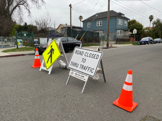
About 13 miles of city streets will be designated as Slow Street zones under the pilot program. Emergency vehicles, residents who live on the street, and vehicles that require access for essential services like trash and recycling pickup or deliveries, will still have access. The City urges permitted vehicles to drive slowly and safely to allow pedestrian and bicycle traffic to safely coexist on the roads. A strict 10 MPH speed limit will be posted, with daily monitoring by community volunteers. Police will enforce speeding infractions, when necessary.
Under the pilot program, the following streets will be temporarily closed to through traffic:
- Oxford and Ontario streets (between Elmwood Avenue and Eddy Street)
- Vermont and Farragut avenues (between FC Greene Memorial Boulevard and Michigan Avenue)
- Waverly and Peace streets (between Union and Elmwood avenues)
- Elmdale Avenue, What Cheer Avenue, and Moorefield Street (between Plainfield and Whitehall streets)
- Leah and Roanoke streets (between Atwells and Academy avenues)
- Brown and Camp streets (between Meeting Street and Stenton Avenue)
- Federal and Ring streets (between Tobey and Dean streets)
- Governor Street (between Wickenden and Angell streets)
- Amherst Street (between Erastus and Bowdoin streets)
- Pleasant Valley Parkway and Nelson Street (between Rosebank Avenue and Walton Street)
- Parade Street (between Chapin Avenue and Westminster Street)
- Eastwood Street (between Merino and Heath streets)
- Camden Street (between Douglas and Chalkstone avenues)
- Roger Williams Park Loop Road (FC Greene Memorial Boulevard, Maple Avenue, and Cladrash’s Avenue)
The temporary road closures will be in effect starting Saturday, May 2, until further notice, 24 hours a day. All off road paths and trails, including Blackstone Boulevard and Pleasant Valley Parkway will be open for pedestrian use.
Additionally, the following greenspaces will be reopened for active use (e.g. walking, running, biking) and local access only:
- Blackstone Park
- Dexter Training Grounds
- Donigian Park
- Gano Street Park
- India Point Park
- Neutaconkanut Park
- Riverside Park
- Roger Williams Park
- Wanskuck Park
Parking lots in these areas will remain closed. Courts, fields and playground will remain closed.
Ahead of the May 2 launch, the Department of Public Works will install signs and temporary barricades along designated streets to divert and slow down traffic. Along with signage, the City will work closely with residents, park volunteers and businesses within the corridors to build awareness and promote best practices. They include:
- Maintaining a physical distance of at least 6 feet
- Limiting group to five family or household members
- Wearing face protection, such as bandanas or fabric masks that cover the nose and mouth (individuals 2 and older)
- Using extra caution when driving
- Staying home if any symptoms are experienced
- Yielding to people who are walking, running, or biking
- Obeying all traffic laws, signals, and signage
More information available on the City’s Covid-19 Website. View a map of the streets in the program.

Time to END the Providence Slow Streets.
While designed to make it safer for residents to walk, run and ride bicycles while maintaining social distancing, there has been no increase in any activity or volume to justify its continence.
It is now a barrier to smooth traffic so vehicles simply go around the barriers.
I urge folks to contact their Councilperson and the city.