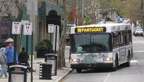
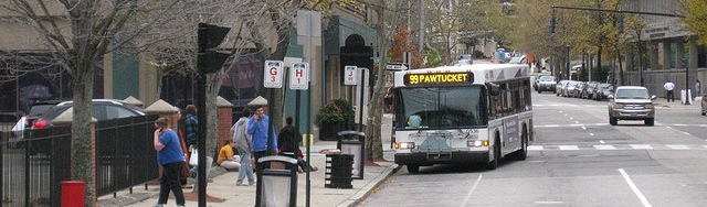
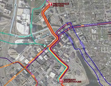
The RIPTA board unanimously agreed to ask a consultant to expand a “comprehensive operational analysis” to include a look at how shifting bus routes to Providence Station and to the Garrahy Judicial Complex would affect service and the agency’s finances.
I’ve heard some talk about this in recent weeks. Without knowing too many details (and the consultant’s analysis will actually be bringing out more details), I think a hub in the Jewelry District helps with the fact that Kennedy Plaza is so far removed from the potential jobs district at that end of the city, and a hub at the train station helps with connectivity to rail. Done right, these hubs could help mitigate the mistake of moving the train station further from the Central Business District and the fact that our Central Business District is less centralized at Kennedy Plaza than it has been through history.


Thanks for calling attention to this development.
Perhaps this relates to an idea in “Transit 2020” that buses should generally go thru Kennedy Plaza but instead of terminating there, mostly go thru to a nearby hub on the west side (near Classical HS) the north side (near RR station) the south side (near hospitals but could be court house) and even the East Side (Thayer St area) If this implements the north and south parts of that it would seem to be a good idea, but if the intention is not to go to KP at all, then it will be highly problematic as KP is still going to be the transfer point, the place for info, and more likely to be near where people want to go than the court house (will there be an indoor waiting room??) or train station (which is already often very congested.) The Ripta Riders Alliance intends to arrange a meeting with Providence Planning and the consultants to assure passenger interests (often ignored by the power structure that doesn’t use the system) are considered.
Reading this really got me thinking about how urgent is the need to do a lot more than tinker with the RIPTA route system.
http://www.humantransit.org/2012/08/portland-the-grid-is-30-thank-a-planner.html#more
The Kennedy Plaza hub and spoke scheme is dreadfully obsolete. The routes are mostly still where the streetcars ran 75 years ago. No planning or guiding wisdom went into the overall route design but there they are and there they stay. As lines were built, each was an isolated endeavor, evaluated only on the likelihood that ridership would pay for it. Thus, one end had to be downtown. The idea of an efficient citywide network was absent. It is time to think about what the system could do if designed from scratch.
The first issue is that RIPTA board is chaired by a suburban Mayor who is not a friend of Providence. That board should be chaired and dominated by folks from PVD.
The second is that RIPTA has diluted the Providence Link trolley system (6 and 92)because of its board leadership.
Third, until we get a Governor from Providence, the state is not a good partner. Just look at what he did on the streetcar system and is doing at T.F. Green…he is “Governor of Warwick”.
A quick solution is to bring Trolley 6 up to the Providence Station and run south through the I-Way/Jewelry District and pints south.
Jeff – do you have any input into getting the trolleys marked with PROVIDENCE LINK on them?
I suggest others interested in this read the article about the Portland bus grid routes that Andrew linked to, and the comments. Having lived in Oregon 1974-75 when Portland was generally considered a failed city, I agree with the praise for the planners that turned it around, in part because of a commitment to transit, starting with trading in the $$ for a beltway around the city for the MAX light rail line. By the way, RI later traded in the $$ for a proposed expressway to Hartford (I-84, vetoed because of its negative impact on the Scituate watershed) but I don’t recall any of the money being used for transit.
That is one difference between Portland and Providence. Another difference is that Portland and Oregon leaders saw transit as an opportunity to rebuild their city and protect their beautiful countryside. I think its not the Governor to blame here, its the city leaders who have always been oriented only to the automobile and basically see transit (except for their unrealistic streetcar wish) as a problem rather than an opportunity for Providence that no other location in the state has. Indeed Chafee sees the Warwick rail station as a development opportunity while Providence has largely ignored its rail station (we had a hard time just getting directional signs for it) which is one reason we now have structural issues there. And it was Chafee, not the city, who got Amtrak to finally fix the station clock!
Oregon had an outdoor culture and even before the trade for MAX there was an active bike program. City leaders agreed to eliminte a wide post-industrial Willamette waterfront roadway (think Allens Ave) and replace it with a riverfront park, now the scene of festivals, concerts, markets… Portland State University, at the edge of downtown, unlike URI-Prov, didn’t give “free” parking, encouraged alternate commuting, as did many other entities. And Tri-Met set up a fare-free zone in the center area that included Portland State, the convention center area, the business district, the train station. RI did the opposite, eliminating the low-cost “short-zone” (50 cents until about 2003) and all fares are now $2.
Portland transit has retreated due to the fiscal crisis and the rise of anti-tax zealots, but is still a relatively successful system.
Another difference: Providence streets are not in a grid a is the bulk of Portland. So its difficult to see how routes here can be restructured that way. Every non-Kennedy Plaza route RIPTA has tried that I know of has had disappointing ridership. I’d be curious how anyone thinks a non-radial system here could work.
I wish we’d stop calling buses trolleys. They’re red buses. Not to say that buses can’t be very useful. But I hate the false attempt at nostalgia. . .
*Sigh*
I think Kennedy Plaza should stay a major central hub, but I’d rather see some kind of bus infrastructure in Garrahy than a parking garage. I suppose there could be other hubs too. But then, what exactly would be involved in that? I’d rather see some nice indoor stations built to make boarding the bus more efficient and get riders out of the cold. I think that would take up less space than building an entirely different Kennedy Plaza-type bus “hub”, and would leave more room for dense development to justify the stop.
A north-south route sounds great. And while we’re at it, I really think we need to have several of those, to make a kind of grid so that you can get from any neighborhood to any neighborhood. I think the Dean/Prairie, etc. corridor would make a great example of this. Make it transit-only at points (maybe not the whole way) and let buses cruise through it more efficiently. Parts of the corridor in the West Side already have no parking and are near dense (potentially denser) areas of walkable commerce. So there’s a bottleneck that could be car free. At the Prairie end, car-free transit-only areas are probably not necessary, but having a designated north-south route would help develop the area. Heck, make a streetcar if that’ll bring more buildings. And redevelop the Dean Street Bridge so that it’s transit/bikes/pedestrians. There’s no need for another exit ramp there when there’s one a few blocks away. Make the cars go around.
Finally some common sense with this news. However, is it REALLY news? Hasn’t this been talked to death already? Enough with the analysis, feasibility studies, special commissions and just DO SOMETHING ALREADY! Simply talking about this over and over is as bad as the transit system we currently have.
I recall that all or part of the Rhode Island portion of the Providence-Hartford I-84 earmarked money was used to demolish the old railroad tracks/retaining walls/platforms and to relocate the tracks to the new station location, as well as, moving the rivers/bulkheads and construction of the new bridges that pass over.
I completely agree with James comment about the “trolley.” It’s like asking someone to decorate their late model car with elements from 1920s cars then insisting on calling that late model car an “antique.” It’s silly and demeans bus or other modes of mass transit.
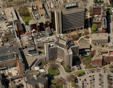
Garrahy will be just a parking garage, a parking garage and a bus hub, or nothing; it will not be just a bus hub without the garage. My understanding is the ground floor would be the bus hub meaning that it would be sheltered. There should be (per zoning at least) a narrow strip of retail facing Richmond Street. Careful consideration would need to be paid to avoid the indoor hub being designed to be little more than a dark, dank, diesel fumed shame hole.
As part of the Comprehensive Operational Analysis, RIPTA looked at moving more buses to the Train Station, but Garrahy was not on the table then, so it was not studied. I’ve heard the planners at RIPTA are quite excited about this possibility as Kennedy Plaza and our hub and spoke system is becoming unsustainable for them.
There’s certainly no reason the bus hub can’t have businesses above it instead of car parking. This sounds like a Trojan Horse to have the city/state pay for car parking, and they shouldn’t do that, garage or not. I’m disappointed at the lack of vision, but what else is new…
The hub could have anything above it but the state is planning a parking garage and is entertaining the idea of adding a bus hub to it. We might or might not like it. As citizens we are certainly allowed to tell our elected officials how we feel about it. But the current plan is to build a parking garage; if RIPTA says it makes sense for them, then that parking garage might get a bus hub under it.
Well, I’d certainly prefer option B. over option A., and I’ll swallow it if I have to, but I think we should try to make some noise about this. Especially because it involves upending Kennedy Plaza on the hope that there will be something better than what already exists. What exactly would one take the bus to at Garrahy? One’s parked car? It doesn’t make any sense. Even from a suburban perspective. Am I going to get up in the morning in Cranston, drive my car to the Jewelry District, park it, and ride the last quarter or half mile on a slow (non-exclusive ROW) bus/streetcar? Why?
Why don’t we build something quality that people want to visit. Philly re-did the Reading Terminal Station (You know, like Monopoly Reading RR) to be a huge everyday/all-day farmers market and restaurant hub. It sits right over the commuter rail hub and subway and near some protected bike lanes. If we’re going to do a bus hub in Providence, why not try to put an attraction like that above it?
Hmm, I am intrigued by this. I guess whether Garrahy is more or less useful for bus customers really depends on where they are going–although Kennedy Plaza seems central because it is currently where all buses terminate, I don’t actually know that it’s that much closer to where most people go downtown. I don’t think Garrahy is so far south as to really be useful for those going to the hospital (or surrounding work areas) who don’t already commute by bus (it’d be marginally more convenient for me, but I am someone who will already ride the bus and walk from KP if the 1 doesn’t happen to be leaving immediately)…
I think the train station is already a pretty easy walk from KP for most, BUT I do think having some buses centered there could be useful for encouraging transit use for those visiting Providence. And would be nice late at night, if buses ran late at night, which they pretty much don’t.
I’ve gone down Garrahy a couple times recently, including via RIPTA to KP. It’s a little bit of a walk, but I think it took me about 5 minutes to get there from KP. The one thing I will say is that if you’re carrying paperwork and wearing nice clothing, it might be nice to be closer in inclement weather (I was there in the rain a couple times). But other than that, it’s really close enough to KP. I have to wonder if the reason for the move is the 195 space though (which currently has no buildings).
Garrahy is 5 very short blocks from KP, less than a 1/4-mile and less than a 5-minute walk. It’s understandable that RIPTA is under pressure for both internal and external reasons to shift buses away from KP, but just because the state owns the vacant land at Garrahy, does creating another hub at that location make sense?
The 195-land will eventually be filled with employment and residential buildings. Locating a hub at Garrahy would likely be an amenity that could assist in encouraging development.
Presently south of Downcity the jobs are at the hospitals and in the JD. The northern edge of the JD would be within a 5-minute walk of a Garrahy hub. Most of the rest would be 10-12-minutes. The hospitals and adjacent offices/labs and CCRI with their 12,000-ish daily employees, visitors, and students would be at best an 18- to 20-minute walk from Garrahy.
Which buses would terminate at Garrahy? Would it only be the 1 and 3 or would the Broad, Elmwood, and Prairie buses be shifted there? Should an alternate south hub around Davol or Franklin Squares be part of the study? Should all the proposed sub-hub locations be studied at the same time? If perimeter hubs are created, whether light-rail or bus, would there be more reason for high-frequency internal Downtown transit service?
It’s exciting to note that the AARP RI retweeted my idea to create shops and apartments rather than parking about the hub. I really hope that PVD politicians and RIDOT will take that idea seriously. Parking is definitely something we’ve got too much of in Providence already, and it’s expensive. Might as well have something nice.
Right, because who cares about the rest of the state? I mean, everyone knows that it’s really the Providence Public Transit Authority, and the “RI” in the name is symbolic. Why, the minute you hit the city line, it’s a total 180-degree shift from walkable urban paradise land into a hell of cars and traffic sewers, completely beyond salvation!
Woonsocket? Who cares!
Bristol? Who cares!
Johnston? Who cares!
Those places aren’t Providence, so we should just give up on them as lost causes. They’re beyond hope, anyway. We’ve got to make sure our priorities are in order! After all, the most important thing isn’t where the people are, where they’re going, or how we can best make sure RIPTA is the best transit service it can possibly be… the most important thing is the invisible line that represents the City Limits.
No, the state won’t be a good partner until the state’s priorities and its elected officials’ priorities include mass transit. Don’t think that just because he’s from one of the correct zip codes that a Governor from Providence would automatically be a shining champion for transit.
It would make far more sense if you were able to ride the last mile on an exclusive ROW.
Personally, I would much rather have a garage than the equivalent amount of street parking. I’ve suggested it before, and I’ll continue to suggest it, but I believe that part of the negotiations and deal-making inherent in the construction of any new parking structures should be the removal of an equivalent amount of on-street parking.
Every one mile of a street parking ‘lane’ contains exactly 264 parking spaces at a standard length of 20 feet. This means that a mile of road with street parking on either side has 528 parking spaces. (In fact, if you wanted to do the simplest math possible, ignoring parking ‘lost’ in the vicinity of things like intersections and assuming an even 10-foot-wide parking lane, you get exactly 5280 square feet of parking in every mile of parking-occupied two-way street.)
Now, 5280 square feet is not that much in terms of building square footage. In fact, you could inflate that figure by a little over 50% to account for travel lanes and still fit that much parking into a two-story garage measuring 80 feet long by 50 feet wide.
Which would you rather have? One mile of street parking in each direction, or one mile of transit-exclusive ROW with an 80-by-50 building built on top of one end?
How about ten miles of transit-exclusive ROW, anchored on either end by a 10-story garage of 80 feet length and 50 feet width?
Of course, this is all academic if we can’t reclaim the tremendous amount of space wasted by street parking for the transit ROW. Agreeing to support a garage in exchange for the removal of street parking also sounds an awful lot like positive compromise. I don’t think we’re going to be able to ever get a total freeze on the construction of all new parking. I do think that we can, and we should, strive for a cap on the total number of parking spaces in Providence.
If you know exactly where you’re going. The walk might be easy, but the route is not well-defined. If there’s anywhere in the entire state where ‘more signage’ really is the only thing needed to solve a problem, it’s the walk between KP and the train station.
…the blockquote tag doesn’t work anymore?
Perhaps you missed my point.
What I was stating is that we must have a metropolitan perspective – the entire state of RI and southeastern MA is the Providence Metro; with PVD being the core. Mass transit systems should be designed based on metros, not states.
Statements like “That board should be chaired and dominated by folks from PVD.” aren’t making that point. I agree that mass transit systems should be oriented on metropolitan areas – but Metro Providence is far more than the collection of neighborhoods that happen to be designated part of ‘Providence, RI.’
I can accept that I will always have disagreements with some members of this community because the actual extent of “Metro Providence” is not clearly defined or understood. As a lifelong resident of South County, I can accept that my attitude of placing the entire state of RI plus parts of eastern CT in “Metro Providence” is certainly well beyond what lifelong residents of the city might be comfortable with.
However, what I can’t accept is the attitude that ‘Warwick’ is part of my less-urban half of the state and not squarely within the boundaries of Metro Providence. Discounting it as some ultra-suburban hellhole for the crime of falling into the same automobile-dependent traps that most of the country did (including Providence itself) is not fair to Warwick, not fair to the region and certainly not fair to Providence. It is absolutely as much a part of Metro Providence as Fall River or Woonsocket are.
Decrying the head of RIPTA for being ‘from Warwick’ rather than for the job he is or isn’t doing is dishonest at best. So is calling for the board to be (your words) “chaired and dominated by folks from Providence” with the implication being that a street address is the most important credential for heading up a transit agency. It isn’t. The most important credentials are a person’s attitudes and actions toward transit, and being born and raised in today’s Providence is no guarantee that those actions or attitudes will be favorable. Nor is not being born or raised in Providence a guarantee that those attitudes or actions won’t be favorable.
OK…
Again, the only point here was to share that without an understanding of the dynamics of the what and how urban metropolitan areas live and work; then the perspective with which to plan effective systems is not adequate to the task.
Without that, you will (and have) seen the “tilt” to decisions that do not assist mass transit in the 10th most densely populated metro in the nation.
The Providence Metro is clearly defined and using it as the basis for planning is very sound…as it has been used in the metros with successful mass transit We have a great opportunity if the right decision makers are in place RIPTA, DOT, etc.).
I have studied these dynamics in over 40 metros and was just sharing…without rancor.
Happy holidays all!
Is Metro Providence really all that clearly defined? I don’t think it is. I certainly would question the wisdom of the official Providence metropolitan area including 38 out of the state’s 39 municipalities but notably, pointedly, not Westerly. I would also question whether a Metro area is solely lines drawn on a map, or if it should be more a reflection of where and how people move about within a region.
But again, more to the point, I don’t think there’s any definition of a Metro region that anybody can make which doesn’t include Warwick as a principle part of Metro Providence. And I agree that having that understanding of how urban metro areas work is important – but I believe that the perspectives of those closer to the edge of the region are just as important as the perspectives of those in the core. It’s important not to discount the needs of the neighboring suburbs of Providence even as we focus on improving the state of things in the core of the city. And fixing the core doesn’t need to be done at the expense of Warwick, or anywhere else.
And upon a second reading of my initial comment, I realize I was a little bit too aggressive in my response to you, so I want to apologize to you for that.
I hope everyone does have a very happy holiday season.
The issue for me is that the state/city should never pay for parking. Of any kind. Ever. Parking garages are fine within reason, with the key caveat being that they’re privately funded. Without that key economic signal, it’s just another subsidy to cars.
I’m intrigued by your idea about ROWs from parking lanes. Sure, I’d be willing to look anew at the horse-trading if that we’re on the table. It’s not. Get the city to put protected bike lanes, pedestrian plazas and transit-only corridors as a part of the deal, and hell, I’ll come help build the garage (but cars still gotta’ pay).
I think if you’re gonna spend $50,000 on an 8×20 rectangle, it might as well be one that sells me vegetables, gives me a job, or houses me. Providence is going to park itself to death.
Sorry for odd autocorrect errors. Were no we’re.
The dominant vision of transit’s utility is sadly inadequate. “How best to design and invest in transit?” for most people is the same question as “What can we implement that will get some trips routinely made by car to be made via transit?” Among commenters here and the population in general, it seems only transplants from bigger cities are able to envision the transit question as “How do we design a system that enables a pedestrian to easily reach a lot of different places?”
The first way of thinking is quite difficult to dislodge from the minds of people who have never traveled more than a few steps from their front door any way but by car. This is why “That board should be chaired and dominated by folks from PVD.” is almost correct. Plenty of people who live right in Providence know only the first way of thinking!
The debate above that boils down to “Screw the suburbs” vs “We must include the entire metro area in our plans” reflects the fact that the second vision of transit is truly a fool’s errand in the regions of unwalkable arterial streets and cul-de-sacs. There is nevertheless a large territory including Providence, Pawtucket, and significant areas of East Providence, Cranston, Johnston, North Providence and Warwick where the second vision of transit service should guide the planning.
I believe it’s this kind of horse trading that stands the best chance of enacting lasting, positive change on the landscape of the city and its neighboring municipalities. Is that an ideal state of affairs? Almost certainly not, but the kind of unilateral action undertaken by governments and automobile interests that got us into this mess to begin with isn’t something we can or should repeat.
Garages can be torn down or re-purposed once their usage diminishes – and it isn’t impossible to marry a garage to some useful/interesting street level purpose. Providence is almost certainly choking to death on an abundance of wasted space in the form of surface lots and street parking, but I don’t believe that we’re at the point where we can fight for and win an ambitious plan to eliminate some sizable percentage of that parking without some kind of horse trading – and I would much rather we continue to take two steps forward and one step backward, which means making some compromises (like garages over bus hubs, or exchanging the equivalent amount of surface parking for one big garage). That sort of compromise isn’t ideal, but it’s far more palatable than having nothing be accomplished, or having transit interests stymied in favor of automobile interests.
I don’t believe the regions of unwalkable arterial streets and cul-de-sacs are lost causes. They weren’t there 100 years ago, and I believe there are paths forward into a future where those traffic sewers are gone 100 years from now.
I do think it starts in the core, and I do believe that effective extensions of the transit-enabled region out into areas like East Greenwich or Attleboro or the upper Blackstone Valley require a strong transit-enabled core.
But I believe, very strongly, that it is a mistake to define the core as just the collection of neighborhoods designated a part of Providence proper. The core does include Warwick (at least as far as the Airport) just as much as it includes Central Falls or Riverside.
And I also believe, very strongly, that the kind of small-thinking, “we can’t do any better than this” mentality that leads people to defend the Core Connector as being the best we can hope for in terms of a streetcar is what is killing us even more than an abundance of parking or highways or transit that leaves far too many people wanting. And I think that kind of mentality is at least in part engendered by an attitude of “screw the suburbs,” or a willingness to write off places like Warwick or Bristol because they’re not Providence and don’t border Providence – when, were it to be located in a place like Texas or California, the city limits of Providence would likely include the entirety of both towns.
We can do better than this. We should do better than this.
Back to the original title of the thread about multiple hubs in PVD: (it doesn’t matter if you came from the core or further suburbs)
The RIPTA Board approved a change order which for the first time directs their consultant to study the multiple hubs in response to “recently raised questions of whether the use of a single downtown hub is still the most appropriate means to serve downtown Providence.” It doesn’t say who raised these questions but some in the Ripta Riders Alliance think it may be KP area real estate interests who want to get the disproportionately low income (an minority) passengers out of there, especially as the background info to the Board suggests “a multi-hub approach could better disperse passengers and buses away from KP…” I didn’t see any mention of a public process in this study, but in light of the interest in this by the gcpvd community, I suggest contacting RIPTA for opportunities for input as the Ripta Riders Alliance has done.
Jef suggested that the current KP system is not “sustainable” for RIPTA but it is not clear to me why that is the case or why multiple hubs would be more sustainable. Others suggested the 5 block walk from KP to Garrahy is no big deal but they totally miss that for many passengers who are elderly or have some mobility disability, that is extremely problematic, as is the prospect for a single woman walking alone after dark (4:15pm these days!) not to speak of weather, sidewalks not shoveled. What would those who work in the financial center and get to park in its building garages think if we told them their parking spot would be moved 5 short blocks to Garrahy (or even across Burnside Park!) Would we expect airline passengers to walk 5 short blocks outside from their terminal to their planes?
Sustainable isn’t the word I would have used – I think a more appropriate term is ‘efficient,’ and it’s certainly tremendously inefficient to have almost no crosstown routes purely because everything needs to reach a hub, if not the hub.
One example is the absurdity of the #51 and #58 routes, which combine to provide complete transit service from one end of Mineral Spring Avenue to the other – but because both buses MUST go to KP, Charles Street becomes an invisible wall. Potential passengers looking to go between North Providence and Pawtucket face an unprotected transfer at the corner of Charles Street, or they can choose to ride all the way into Providence just to ride all the way back out on the other bus.
Not that decentralizing KP into several hubs roughly five to ten blocks from each other actually improves this situation very much, because the fundamental issue at play is the fact that perfectly serviceable crosstown routes are at best broken up into two or more disjointed parts heading downtown and at worst abandoned entirely. That’s going to continue to happen whether ‘the hub’ is the train station, Garrahy, KP, or divided out amongst all three. At best, terminating buses at the various sub-hubs means slightly less backtracking for people trying to move crosstown instead of through downtown, but probably at the expense of those people trying to move through downtown or to/from downtown (unless this sub-hub scheme is paired with extremely frequent hub-to-hub bus service, which is doubtful.)
The thread did go of topic prior to Barry’s last comment, but some of those points need to be addressed, which follows:
Besides Andrew I’s suggestion of “second vision of transit,” there are several other locations within and outside of the core, including CF, Woon., Newport, downtown Bristol, Warren, EG that predate the auto-centric built environment and culture and could be nudged back or shifted to transit usage levels similar to that of Providence, assuming service improvements.
The significance of the proposed and partly implemented route changes resulting from the COA needs acknowledgement. The study is an extraordinary body of work that should improve and transform the system from what it’s been for the last 50 years.
It is true that Providence Metro includes all of RI and Bristol County, MA, and effectively the edges of CT. Basically RIPTA is limited to the boundaries of RI and funding comes from the state. The majority of the state’s population is from suburban and rural areas. It’s critical to get as many non-urbanites to use or at least understand the importance of mass transit for the economy and environment. Without their support there’s little hope of maintaining or expanding the system beyond today’s levels or proposed COA improvements.
The current Governor has been a spectacular disappointment for mass transit, but it’s unfair to assume that Mayor Avedisian is the same just because he’s Mayor of Warwick. Much of what I’ve read or heard first hand from people at RIPTA about the Mayor is that he truly understands and has been a vocal advocate for RIPTA and mass transit.
It’s utopian to propose streets devoid of parked cars. Even if the Providence area were to magically achieve the transit levels of New York—cars aren’t going away. If auto usage could get back to 1910s and 20s levels there would remain a need to allow for deliveries, drop-offs and pick-ups. As far as parking goes, it’s preferable to house cars on the street or in structures rather than in surface lots. Downtown and most of the commercial corridors in Providence and adjacent cities have upwards of 40% or more of land devoted to parking and car use, which I contend has been much more destructive to the urban landscape than parking cars on the street.
BTW a structured above-grade parking space costs about $30,000 each. $50,000 is typical for an underground parking space. A trade off could be proposed for a Garrahy garage where parking requirements could be lowered in the remainder of the 195-land and adjacent Downcity and Financial District neighborhoods.
Regarding the topic of this post, I as well as Runaway Jim did point out that Garrahy is 5-minutes or less from KP. I’m in no way advocating for the Garrahy hub. I don’t believe that it will work or that it’s necessary given how close it is to KP. It’s not a secret that KP real estate interests and the park improvement people would love to socio-economically cleanse KP, which is likely where this idea of a Garrahy hub came from. The current KP single hub has problems and developing multiple hubs or terminals could create new problems or hardships for everyone that uses the system.
Are there other alternatives? Here’s one that doesn’t involve hubs:
The orientation of Downtown is roughly east/west. Even the majority of bus routes that originate from the north and south enter the downtown area from either the east or west. Instead of having a bus hub(s) or a terminal(s), why not develop a Downtown Transit Loop. (think Chicago Loop only for buses). Such a Loop could follow in a one direction. Example: Washington Street – west; to Empire – south; to Weybosset – east; to Exchange Street – north; continuing back to Washington – west.
All buses that enter downtown would travel the entire length of the Loop though they would enter and exit the Loop from different streets depending where their origin or destination is.
Passengers no longer would be dumped in KP or at another set location. Instead people could get off their bus anywhere Downtown along the Loop. Transfers could easily be made anywhere along the Loop where there’s a bus stop. An intermittent bus lane a few blocks long could be striped at bus stop locations. Multiple bus stops could be established along the Loop with more substantial shelters. The KP building with toilets should remain in use and perhaps be renovated. Another “comfort station” to use an old term could built on somewhere on the Westside of Downtown along the Loop. There could be designated dwell zones for buses to correct schedules or allow for driver changes.
Such a loop system would offer the maximum flexibility for expansion of the system. An alternate could be to have a double loop as what’s currently proposed for Downtown Pawtucket.
Hear Hear, Andrew!
Ryan, I appreciate the outreach, although I think we should try to build the right thing the first time, not aim to tear it down (especially when it’s such an expensive wrong thing).
Also, agree totally about silly transfers like between the 51 & 58. There really needs to be an everywhere to everywhere approach to transit (or at least, everywhere walkable to everywhere walkable) in order for people to feel that transit is an option that makes sense.
I think several hubs is fine, but again I would go back to the idea that the key is that the hubs have to have something worth traveling to, and parking ain’t it.
Peter, I wanted to quote from you:
“It’s utopian to propose streets devoid of parked cars. Even if the Providence area were to magically achieve the transit levels of New York—cars aren’t going away. If auto usage could get back to 1910s and 20s levels there would remain a need to allow for deliveries, drop-offs and pick-ups. As far as parking goes, it’s preferable to house cars on the street or in structures rather than in surface lots. Downtown and most of the commercial corridors in Providence and adjacent cities have upwards of 40% or more of land devoted to parking and car use, which I contend has been much more destructive to the urban landscape than parking cars on the street.”
I agree that parked cars on the street are better than parking lots (and I’d maintain better than garages too. We have enough garages, in my humble opinion. Building more anticipates more car traffic, and we should be physically constraining the growth of car traffic at the very same time that we open the door to more ways to get back to the city from other places, or from neighborhood to neighborhood within the city, without a car).
I don’t actually envision a parking-free street, in most places. In a way, I said that because that would be the threshold that would get me to agree to the state/city funding a parking garage. It’s a very high one. I think utopian is fair.
I do think it’s realistic (and necessary) on some streets in Providence to remove parking in order to create transit lanes or bike lanes. Andrew gets to something about there being a lack of vision because of the smallness of Providence. Providence tells itself it has narrow streets. It mostly doesn’t. I can think maybe one worth note, which is Westminster in the downtown. Philly has its share of wide roads, for sure, but it mostly has a lot of streets that are like Westminster, especially closer to the core, and those streets have to carry a lot more traffic. Yet Philly was able to take a street like Spruce, which had two narrow travel lanes and no parking on it, where residents didn’t have driveways because everything was a rowhouse, and make one of the two lanes for bikes only. It’s been a great success. And they took the next street over, Pine, and did the same, coming the other way.
It’s been such a success, in fact, that the Bike Coalition of Greater Philadelphia recently posted something about how a doctor who had grown up in Rome but lived in Philly moved back to Rome to become the mayor, and he took what he learned in Philly–“Philadelphia taught me to live without a car”–and applied it to one of the most autocentric European countries, Italy. He removed cars entirely from a wide boulevard that Benito Mussolini had rammed through the central core in the 1930s–something akin to barring cars from Memorial Boulevard–and convinced Romans (who love their cars) that this was a good idea. Go Philly.
Providence has these streets where you have only two travel lanes, and they’re not *that* wide, but there’s also two rows of parked cars. Washington is an example. That’s not narrow! Even Benefit Street isn’t that narrow. Do you know *why* it’s called Benefit? Because they widened it to make it an arterial “for the benefit of all”. It was that time’s “wide” street!
Removing some parked cars form some streets in some places in order to make protected bike lanes is the only way that Providence will ever get to double digits in its bike mode-share, which frankly, it should be able to do, because it’s flatter and denser than Portland and has less severe winters (w/o tornadoes, I’d add) than Minneapolis. There’s no reason we can’t make Providence a real example to the world, something that would lead someone to go back to their home country with inspirational ideas and do something “because Providence taught me how to live without a car”.
Breaking up the KP hub into several minor hubs around downtown preserves all the disadvantages of the present hub and spoke scheme, and loses the passenger convenience a single hub does provide. Ouch. The “transfer anywhere along the loop” idea has merit, but not if what should be expeditious through-running routes have to wind this way and that, stopping at every corner. A separate downtown loop or circulator is a better solution for passengers whose bus into town leaves them a problematic 5 blocks from their final destination.
Ryan illustrates the inefficiency of the present route system that minor changes to bus stop locations downtown will do nothing to change.
“One example is the absurdity of the #51 and #58 routes, which combine to provide complete transit service from one end of Mineral Spring Avenue to the other – but because both buses MUST go to KP…”
Every route does not need to go to KP! The absurdity is that every “Mineral Spring Bus” now spends more time on Charles street and in downtown Providence than it does on Mineral Spring. Consequently, buses are too infrequent along Mineral Spring. Also, there are always dozens of buses going by in downtown Providence, but the one that goes where you want is always a long way off.
Downtown should be served by a small number of high frequency high capacity routes that move briskly through instead of pausing at KP or some other hub. North-South, East-West plus a very few diagonals. If you are downtown, there is never a long wait for a bus leaving in the direction you want to go. These routes meet crosstown routes like Mineral Spring – Central Ave, Potters – Public – hospitals, Park Ave in Cranston, a far west north-south route serving RIC and Olneyville, and another north-south route via Dean St. and a major north-south route through East Providence. The #60 connects to north-south routes in East Providence. Warwick can have routes that connect neighborhoods to the malls, the train station and the rapid, frequent line into Providence.
In such a a networked system, anyone near Mineral Spring could count on a Mineral Spring bus arriving every few minutes, to Centerdale or through Pawtucket to, say, the T at South Attleboro. There will never be a long wait for a quick ride into Downtown Providence at Centerdale, Charles or downtown Pawtucket, whichever is closest or offers the shortest wait. Transfers are also available to the other north-south routes proposed above.
Some passengers now perfectly satisfied with their one-seat 8:15 to KP will instead face a transfer. They will squawk. If ridership allows, some rush hour specials could be added.
Such a RIPTA route overhaul will upset a few existing users but it will provide unprecedented mobility options to thousands of people who now (rightly) consider RIPTA useless. Instead of muddling through insignificant incremental changes like breaking up KP into mini hubs, or a slow trivial downtown streetcar, RIPTA needs an ambitious vision for regional mobility and it needs to start selling it now.
I dont want any changes to Kennedy Plaza. The two hub concept will cause more problems than it solves. Elderly and disabled would not be sble to make the five blocks and there is a problem with crime. I think well enough should be left alone.The people who want these changes dont take transit. They are car centric and dont take intoaccount people who cant drive due to income or disability.
Does everyone who arrives in Kennedy Plaza today have Kennedy Plaza as their destination? No one ever gets off a bus in Kennedy Plaza and has to walk anywhere beyond the confines of the existent bus lanes there?
I do think that it’s utopian to suggest that Providence can to zero parking under any circumstances.
However, it’s far from utopian to suggest that there are plenty of roads where the street parking is extraneous, counterproductive, and an easy source of potentially protected ROW in parts of the city where getting that ROW is otherwise going to entail an extremely messy land acquisition process – those ‘narrow roads’ James mentions, the ones which aren’t really all that narrow once you stop treating parking lanes as a given and a necessity.
Broad Street doesn’t need street parking nearly as much as the R-Line needs a protected ROW anywhere we can establish one.
I doubt that very many businesses on Wickenden Street would be put in jeopardy if its parking lanes were lost to make room for actual trolley tracks. Atwells Avenue? Probably the same deal. The biggest obstacle here is getting the impacted business owners on board with the idea that a bus (or, hell, for those two streets I’ll even go along with calling the red bus-in-disguise a ‘trolley’) which runs by their front door every 5 minutes from 6 am to 10 pm might be better for business than the lane of parked cars is.
I wish they’d get rid of street parking on Atwells and widen the sidewalks so there’s room to walk around the outdoor tables. But that’s a topic for another conversation. Perhaps both of those goals can be achieved.
I have a crazy plan in my head to close Atwells, maybe someday I’ll write a post about it.
Is there a precedent for the idea that limiting parking and traffic on a main thoroughfare would actually increase the activity on the side streets? If the main street is already a destination, any focus on the side streets might be beneficial.
What Andrew said about short, straight, predictable, frequent routes that network to each other is totally true and I wish RIPTA would implement it right away.
Closing Atwells is a great idea. There are a lot of streets around the world with a similar amount of pedestrian and retail activity that have been closed to cars with great success.
Back to the loop. After writing that comment, it did occur to me the problem with thru-running routes. If I understand the COA proposals correctly, most of the thru-routes are being decoupled. I believe the only ones remaining will be the R (North Main / Broad) and the 1 (Hope / Eddy). If those are the only two, they should be exceptions that should follow a single linear path in both directions. All the other routes could follow a loop.
I love the idea of a closed Atwells.
Human Transit blog wrote a set of pretty good pieces that were expanded into a book explaining the “geometry of transit” and saying that under most circumstances, a loop is definitely not what you want. If you’re on a clockwise loop going from 12 to 3, it works nicely, but getting from 12 to 9 makes you take a longer trip than you would ever want to take for such a trip. Think: People Mover in Detroit. You really want linear services with short(ish) frequent lines, that have lots of potential transfers to other linear perpendicular routes.
James Kennedy:
I looked at Jarrett Walker’s piece “The Geometric Shapes of Transit’s Success.” I also looked at Vancouver’s Transitlink routes that he illustrated. Generally I agree with most of what Jarrett says, but this piece is about the geometry of Vancouver’s highest and lowest performing bus routes is misleading.
It is true that the illustrated highest performing routes were mostly straight, but for the most part those routes terminated downtown or if not they terminated at a train/light rail/rapid bus station or traveled along long commercial corridors mostly in or near the city core.
By contrast most of the lowest performing routes were in peripheral inner city areas, suburban, or one case a remote coastal area. There was only one short loop that was in the downtown vicinity. Some of those routes had no Sunday, weekend, or evening service or just ran at peak.
I take your point about the 12 to 3 or 12 to 9 o’clock as far as the length of time to get to a stop. This might or might not be problematic for RIPTA routes that terminate Downtown, since all routes will have picked up their passengers prior to arriving Downtown. Some passengers would transfer to other bus routes and others would have Downtown destinations.
One question would be how many of those passengers have destinations that are in the immediate KP area? Might they be going to other parts of Downtown? The Empire Street/Weybosset Hill area has a lot office space, which besides commercial includes City and Federal offices. The States DCYF office is on Pine and Richmond and of course the Garrahy courthouse on Dorrance, all of which are further from KP.
If a terminal loop was established Downtown, depending on the route origin, buses would enter anywhere along the loop. 3 o’clock for one route might be 9 o’clock for another. If all terminal bus routes (not thru-route buses) stopped at every stop, for those transferring to another bus, it wouldn’t matter which bus stop you got off at. So it’s likely that people would get off the bus as soon as it was convenient.
The suggested loop is roughly a mile in length. If I did this math right, with traffic, 5 or 6 bus stops, and signals, and assuming that the average bus speed in 5 mph, it should only take 12-minutes for a bus to travel the entire loop, or 9-minutes to get to 9 o’clock. Would 9-minutes be too much of a delay?
9 minutes would not necessarily be too much for me (Although, I’m kind of lying. What I mean to say is that 9 minutes would make me drive a car. It might make me walk or bike instead. And, in fact, I principally use RIPTA for very long trips across state, or for trips where I’m extremely ill or carrying something very heavy, and otherwise mostly don’t use the system at all, because I have the luxury of being a young vibrant non-driver instead of an old, disabled one).
One thing to keep in mind about Jarrett Walker is that a lot of the systems he’s worked on are on the West Coast, in Australia, or New Zealand, and all of those places are designed in some ways very differently from Providence. He does say in his book (I’m not sure if he also says this in the online article) that a loop can be fine for very small circles, and perhaps by the standards of Los Angeles or some extremely sprawly city, Providence’s circle wouldn’t be so big.
You also have to think about the relative cost of the circular route. I really found his economic arguments engaging in the book as well. He points out that the labor cost of the bus driver is in time, not miles, and so that’s one of the reasons he talks about producing short, linear routes. He says he’s just “answering plumber’s questions” about “what do you want with your system?” but I also think in reality he very much favors a transit system that focuses heavily on areas where transit will be most useful for moving lots of people, rather than as a safety net service for a handful of people with no other options. So you can have a loop, but that’s x number of buses and bus drivers committed to a pretty slow service (you say 5 mph, and that sounds about right to me). Young people might just decide to walk. People who are older and have more stable careers may drive, and the people left in a crunch in between are those who are too poor to own a car but who don’t have the mobility of a young person. He says, essentially, don’t create a transit system to compete with walking. Create a transit system so that someone who can already walk can amplify how quickly they can go across town.
I feel the same way about a bunch of the West Side routes, and to some extent the East Side ones, even though they’re (sort of) linear. Why have a 92, 27, 28, 19, 17, 33 (I think?), etc., when you could combine that capital and labor cost into creating–without new equipment or outside funding–one very frequent bus that runs down a single street. You could even only combine half of the buses into that route, to increase frequency but leave room for a connecting north-south route (I think Dean St., which eventually becomes Prairie and cuts through most of the W. and S. Side neighborhoods would be a good contender, if we could get parts of it at key bottlenecks to be transit-only). The argument is that if your bus comes every five minutes instead of every two, has its own right of way so that it can go 30 instead of 5 mph, and has pulsing transfer points that are geographically simple, you can use transit well to get from anywhere to Panywhere). There are some challenges because Providence is less grid-like than some other cities, but he also says that natural bottlenecks of which we have so many in Rhode Island can create more incentives to use transit.
You have some equity questions raised when you remove service from a bunch of streets to create one solid route. You’re basically giving preference to a certain corridor, and you’re leaving out others. So how do you fix this for people who are disabled? I think it would be more efficient, and better for disabled people, if we created some really good transit lines, and then sought to help them live closer to stops, than if we tried to snake every bus in and out of the Walmart parking lot and down every cul-de-sac in South County to meet the disparate needs of people living all over. I’ll some day be old, and I want to live where things are dense and walkable then. Let the young people live in the sprawly suburbs and take bike paths to the bus, or something. 😉 Much better than creating a route that works for no one but those who are desperate.
The loop system you’re describing reminds me very much of the PATransit downtown service in Pittsburgh PA. Most buses coming downtown (which admittedly, seemed to be most, since it is yet another hub and spoke system, though without any transit center), but just about every bus made some sort of loop inside downtown (very little through-routing as well, bus would loop and go back on the same route it came in on, adjusted for one-way pairs). Add to this a “free” downtown zone. While if you didn’t want to go downtown, the system didn’t serve you well, and almost all long travel required a change in the downtown region, wait times were pretty low (at least weekdays). If you were downtown and needed just to move across town, it almost didn’t matter what bus you got.
Matt,
I’ve never gotten the chance to use transit in Pittsburgh, or for that matter, to bike or walk around much. I went there with a past partner some years ago, and she insisted on driving everywhere. I’d love hearing more about Pittsburgh sometime. The Rhode Island in me makes me feel ashamed that the respective cities of Pittsburgh and Philly have so little interaction with each other over the vast expanse of Pennsyltucky that is the middle of the state.