As RIPTA prepares to introduce its new R-Line rapid bus service next month, and reroute some buses in September based on the recent Comprehensive Operational Analysis, the agency is also planning for how to operate in Downtown Providence in the future.
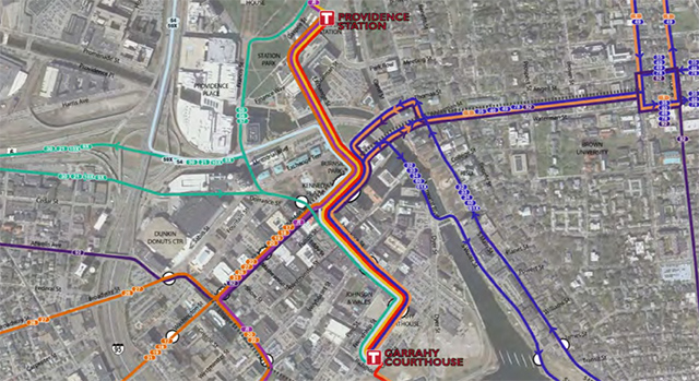
Ideas for the future include physical improvements to Kennedy Plaza and the creation of two new bus hubs, one at Providence Train Station, the other behind the Garrahy Courthouse off Dorrance Street.
Information from RIPTA on the recent studies they have undertaken:
RIPTA has commissioned several recent studies to seek ways to improve the transit experience for Rhode Islanders. Rising ridership and the need to provide service that best meets demand in our state has driven recent evaluations of RIPTA’s operations, including the Comprehensive Operational Analysis (COA). As almost all RIPTA routes access Kennedy Plaza, it is expected that operations at this location would be more closely studied. RIPTA, in partnership with the RI Department of Transportation and RI Statewide Planning, is conducting a downtown transit improvement study, Downtown Transit 2.0, to evaluate whether the introduction of additional downtown Providence transit stations could improve service for existing riders, enhance downtown accessibility and mobility, and resolve operational and passenger experience issues at Kennedy Plaza.
When cities outgrow a single transit hub, the most common approach is to identify additional transit centers and to integrate bus operations in a manner that expands service coverage and improves overall transit service. Buses can be routed to pass through and serve more than one transit center, providing passengers with more convenient access to new locations and better distributing volumes of bus traffic. This study evaluates whether this approach could both improve transit service in downtown Providence and resolve growing operational challenges at Kennedy Plaza. New transit centers will be considered in the vicinity of the Providence Train Station and in the Jewelry District.
Introducing new transit centers and terminals may also offer secondary benefits of meeting desired community development goals, including the revitalization of the Kennedy Plaza/Burnside Park area, providing better connections to Providence Station to support continued growth of commuter and intercity rail ridership in Rhode Island, and meeting City goals for desired development on vacant parcels in the Station area and Jewelry District.
This study has the following primary goals:
- Improve service for RIPTA riders and attract new riders
- Address operational and security challenges at Kennedy Plaza
- Develop cost-effective solutions
- Support local community development goals

The best thing they can do to ensure the usefulness of those stations is to make sure that the uses above them and around them are dense commercial and residential space and not parking garages. *fingers crossed*
I like the idea of the 2 new hubs. It improves intermodal conections, gives transit users a wider choice of downtown destinations, helps city redevelopment, and by reducing dwell times for buses and the need to transfer at Kennedy Plaza, it relieves overcrowding there. I think the Governor, RIDOT, and RIPTA deserve some credit for pursuing this, and I hope they get the TIGER plannng grant to move it along. If they do, they should be able to answer questions about the details.
It ahould be noted that at the Senate finance hearing on the hubs, we heard the additional operating costs to extend all the lines to the new hubs is estimated at about $3.8 million/year. For this to work, the state must ensure a funding stream to cover this.
But it is no sure thing the legislature and the voters will approve this. If they don’t, we will be left with an inadequate Kennedy Plaza, especially if the city moves ahead with its redesign there that would reduce the number of bus stops by about 3 or 4 (even as ridership is climbing) , and disperse some stops, making conditions worse for many passengers. Therefore the Ripta Riders Alliance has asked the city to suspend the project until passenger concerns are addressed, we know about the future of the hubs, and a new Mayor can take a fresh look.
And James makes a good point. If we cotinue to spend a fortune on “free” parking (as we do now for state employees, URI-Providence students/faculty/staff etc) then the transit system, including the commuter rail extension, cannot succeed in attracting enough riders to help much with city revival, environmental quality, reduction of congestion and such.
This plan if implemented would be a windfall to Rhode Island mass transit.
Besides the two new hubs, according to the plan there would be about 15 superstops or stations, most of which would be no more than a 2-minute walk to any downtown location. In the outer reaches of the Jewelry District and State House area the walk might be just under 5-minutes.
In a presentation about this proposal it was mentioned that headway frequencies between the three transit hubs would typically be every 1-minute. That’s equal to or slightly better than the New York subway at rush hour! I think they said that along Washington Street the frequency would be in the 6- to 7-minute range.
To insure widespread use and success of this plan, the downtown “Short Zone,” extending to the Thayer tunnel portal, the Hoyle Square high schools, the hospitals, and state offices should be re-introduced.
Can anyone tell me why many of these bus lines must terminate in downtown Providence in the first place? If Kennedy plaza is really the transfer hub of the whole system, why not reduce the number of total transfers and people waiting for buses by increasing the number of through routes that do not end in downtown Providence?
The NYC subway doesn’t terminate at Grand Central, and neither do most of the trips taken by the riders. Spending millions to simply divide our hub and spoke transit system into two hubs within a leasurely ten minute walk of eachother doesn’t solve the underlying problem in my opinion.
Arman makes a good point. The 11-99 lines (Broad-Pawtucket), 1-42 (Eddy-Hope) and 92 (Atwells-Fox Point) do still run thru K Plaza and do not terminate there. However, previous to the COA (Comprehensive Operations Assessment) the 17-57 (Dyer-Smith) 50-28 (Douglas-Hartford) 31-56 (Cranston St-Chalkstone) and 3-33 (Riverside – Warwick) all were also thru routes (“interlined”) but for some reason the COA consultants Ripta hired recommended breaking them. I opposed this, especially as the north-side lines (50, 56, 57) serve the mall, rr station and State House area making many more one-seat rides to marketable locations. To no avail. I know some drivers didn’t like the run-thrus (changing drivers in KP? lost transfer revenue?) Arman is also right about convoluted routes such as the 17 which no longer interlined, inbound circles all around KP.
However though not shown in schedules, the 57 is now interlined with Route 20 (Elmwood, though the 20 is more frequent, only 1/2 go on to 57) and I believe the 56 with 21. Ripta planners told me the COA is still a work in progress and this may be temporary which is why it is not shown in schedules. They also think the interlined route printed schedules can be confusing.
But I agree with Arman and believe transit advocates should push for as many interlined routes as possible. I would have thought the city interests that wanted to reduce the bus presence in KP would have been an ally on this but I am unaware of any interest they had in this.
A question to those following this thread: A transport world colleague was most annoyed that the ripta-riders-alliance is asking to delay the city’s KP project (to redo KP, reducing and dispersing bus stops.) There is a problem leasing space in adjacent buildings and attracting visitors to KP due to the large # of buses and passengers (lets face it, disproportionately students, low income or minority) hanging around. I’m asking: Do people think that reducing 16 bus stops to 9 in the Plaza itself, keeping the terminal building there, and dispersing 4 new stops around Burnside Park, eliminating 4 bus-only lanes but keeping the same total # of buses and passengers (and cars) in the area, will make a significant difference in the desirability of nearby buildings and/or attracting vistors to events in KP?
Thank you for filling me in Barry. Did the COA ever consider renaming routes so that the interlined routes would share the same name…effectively become one route?
I’m also curious if they considered consolidating routes to create additional transit corridors with multiple routes?
An example would be re-routing Westminister st. buses to either Broadway or Cranston St. to increase frequency on those routes. I’m curious if riders would be willing to walk farther to a bus stop for the promise of more rapid service (again similar to NYC subways). Most bus riders I know spend far more time waiting for buses, than actually walking to the bus stops in our current system.
Barry, In my opinion the primary way to improve Kennedy Plaza is to find someway to reduce the number of people waiting for buses and arriving there simply because “it’s the end of the line”. Also consider that while Burnside park has no bus stops actually inside it, it’s still generally full of the same people who hang around Kennedy Plaza. Loiters in the plaza are there precisely because of the factors and amenities you propose to maintain.
How would simply reshuffling the bus stops change this?
I’m a personal advocate of turning the whole plaza into and extension of Burnside park and moving the hub somewhere outside downtown, such as Broad St/Cahir st.
The whole restructure of Kennedy Plaza is suspicious. Ever since the kiddies took over Burnside Park there has been a push to get the dirty people out of Kennedy Plaza.
I recall it all started a few years ago when the Pride Festival got pushed out of Burnside Park over to Station Park because the kiddies had some thing going on in Burnside.
Now we’re stuffed over by the river of course.
I like where this is going in the preliminary.
However, I would like to see a direct line extending from Wickenden St./Fox Point to The Jewelry District/West Side/So. Providence via Point St.
Andy, I’ve always wondered why there is no route going that way. I do feel like an E-W route there would need to run very frequently to be well-used given the short/flat walking route (though it’s currently kind of a nightmare, I’m hopeful that the construction will eventually result in a pleasant pedestrian route?). Given the way traffic backs up on Point Street in the PM (and presumably AM, though I witness that less often), a nicer pedestrian route and a bike lane might be more useful to most of those moving back and forth there frequently.
@Jen
Complete nightmare and until a safer and more pleasant per. route is installed and maintained… and some business to make walking the route worth the walk, there ought to be a bus line. Presumably, there would be less passenger cars along this corridor if buses were an option. Davol Sq. would be a nice “Super Stop”.
I live on Wickenden, work in Washington Park and have friends who live on the West Side. To get to or from either of those places takes more than 45min to an hour by way of the current system – so I choose to drive instead. Biking is still too dangerous.
@Jen
PS. Another reason I’ll continue to argue AGAINST making the former Dynamo House Power Station into anything but a publicly accessible venture – perhaps into a major transit connector hub with streetcars, busses and connections to cabs, bike shares and the future (if ever) pedestrian river bridge and CityWalk.
Not the right use as a nursing school or any school without a viable public use.
The 92 could do what you’re proposing, instead of the current asinine plan to terminate it at Thayer Street in the Core Connector study.
Transfers can help our system, but it depends on how we use them.
The hub-spoke shape is bad. Successful transit systems create as close to a grid (a modified grid is fine where streets don’t cooperate) so that transfers happen between major east-west, north-south lines throughout the city. Dean-Prairie for instance would make a good north-south, for instance. There should be a line that goes directly between Wickenden/Point and Broad, as another example. The 42 should not go to KP, but should terminate at Wickenden and transfer. The 92—oh, how I hate the 92!-would do better not to wiggle all over the place, but spread its rolling stock and drivers out to different lines.
The real question is why the routes should terminate where they do, rather than transfers per se, and why there aren’t rights of way on busier roads (could we reconnect the backstreet of Atwells for cars, where Pastiche is (or visa-versa) and prioritize transit on Atwells if we’re going to have an Atwells line, for instance? The 92 just sits in a waste of highway-induced traffic).
I hope getting more linear routes becomes something people can get excited about soon.
James… you actually got me thinking and it’s not related to the bus. What if the Atwells exit was eliminated? Is it necessary? Couldn’t exit 22A handle that traffic? Memorial Blvd is what… a third of a mile from Atwells, maybe half a mile from the current Atwells exit?
Anyway, I’ve dreamed of a Dean St route as long as it terminated at PC. I think it would get a fair amount of traffic as there are plenty of people up there. Heck, I’d probably use it, taking the 56 to it. The only issue is size of the road. Is Dean St south of Atwells wide enough? I would actually use RIPTA if buses ran a little more frequently and if the routes were more linear (and not linear towards KP).
Jim: Actually, the Atwells exit (and its Broadway counterpart) are doing far more harm then good, and elimination of them would be outright beneficial to drivers and should have been rolled into the viaduct replacement as part of a comprehensive overhaul of the outright worst collection of interchange ramps anywhere in the state.
Today, northbound traffic seeking Atwells, Memorial, 6/10 or the mall must weave through traffic entering from 195, and that traffic similarly must weave through in the other direction to avoid being forced off of the roadway. In this particular instance, because of the proximity between all the relevant ramps, widening the road would have the exact opposite effect. Even if no induced demand occurs to pour more vehicles into the extra general traffic lanes, the simple fact of the matter is that would be an extra lane that weaving traffic would be required to navigate, exacerbating the problem instead of mitigating it.
What really needs to happen is that the entire interchange needs to be torn down and reworked, with exit 21 on both sides of the road eliminated as part of that reworking.
Yeah, I wrote that about a year ago, and Jef published it. Exit-stensial Problems at Dean Street.
http://transportprovidence.blogspot.com/2013/02/gcpvd-exit-stential-problems-at-dean.html
I’m sure I’m not the first to think of it.
It’s one of the first things I wrote about urban design in the city, come to think of it. It’s so obvious. The highways act like collector roads for local trips instead of ways to get to Boston or Warwick, etc.
It would sure save a lot of money! And I think some DOTs remove exits and entrances in order to make highways function better.
Impressive! RIPTA may be stumbling on the only design for a transit system worse than hub-and-spoke: Spokes that go to “dispersed” hubs so some transfers will become even more time consuming.
Under the present hub and spoke system, most people who live near a bus line have infrequent service that is reasonably useful only for travel to downtown Providence. If you need to go anywhere else, it can take hours.
We need a system with fewer spokes, each with faster, more frequent downtown service and a good number of new crosstown routes like Wickenden-Point St, Dean Street-PC (mentioned above), a North-South route linking Cranston to RIC via Olneyville, Park Avenue in Cranston and others. This would permit thousands of trips that are now practically impossible.
It is only half good to see attention being paid to the RIPTA Riders Alliance. Unlike everyone else they actually ride the buses! The sad thing is the current arrangement is working for them so they will naturally oppose significant change, especially change that replaces their one-seat ride with a need to transfer, even if the frequency at their stop increases dramatically.
No one seems to be looking for a way to transform RIPTA into a system that would appeal to the majority of people now unable to use transit even if they might wish they could.
This is exactly the kind of thing I am trying to say:
http://www.humantransit.org/2014/05/houston-a-transit-network-reimagined.html
Wrote this in 2010:
http://www.gcpvd.org/2010/11/15/the-core-connector-system-should-connect-more-than-just-downtown/
This piece was about streetcars and occupation districts. It could easily apply to bus routes as well. See last map in the article.
I am slowly, wistfully realizing I will not live long enough to get to see how The Future turns out. But listen up all you young whippersnappers: At the rate things are going, neither will you live to see anything but the same old same old!
Hey, that was young me commenting back in 2010!
Eliminating the Atwells and Broadway exits would essentially leave one exit point for downtown from 95 North and South. I think the amount of traffic that would be diverted to Memorial Blvd would quickly overwhelm the Memorial/Francis intersection (which itself is a nightmare)
I would be in favor of eliminating the Broadway exit from 95 North if they would replace the signage at Point St to indicate you can get downtown from there. The service roads are pretty efficient. I use that exit more than Broadway. of course i do so because nobody else uses it right now.
The Atwells ramp from 95 North is definitely needed. If you miss 22 the next exit would be the hospital with no easy way to get back downtown. Also putting all southbound traffic to exit 22 would make the current 146 merge even worse. I think the current Atwells exit needs to be reconfigured to separate downtown and Federal Hill traffic. Personally I would have liked to seen them take that small building at the end of the ramp to allow a bailout lane to Federal Hill avoiding the light. But the viaduct replacement is keeping the status quo.
What really needs to be reconfigured is the Dean St/Rt 6 connection. I don’t know why you can’t make a left to Rt 6 W from Dean and why 22B can’t terminate at Dean instead of the walled off lane forcing you on to Providence Place (Promenade). A light at that point could control both ramps.
The Atwells exit is really a waste. It gets so backed up, it backs up onto 95. The ramp is too short. It also causes more traffic on Atwells than Atwells can realistically handle. And, realistically, does it matter if someone misses an exit? Is it that much of a problem? What happens if you miss an exit in any other city? You’re often screwed and have to turn around. People who don’t know where they’re going use a GPS and if they think they’re fine hanging out in the left lane until the last minute, they’re asking to miss the exit. And, you know what? If they miss it, the GPS will tell them how to get where they need to.
Exit 23 also provides easy access to downtown from 95 south, even if it doesn’t put you right there. And I suspect a lot of people who know where they’re going take that instead of 22 (I know I do) because it avoids the traffic coming off 146.
One reason the Atwells exit gets jammed up all the time is because Atwells proper has become a nightclub zone.
Plus they have significantly narrowed the ramp due to reconstruction of the viaduct.
So in case anyone has any questions why transit struggles to get funding, here is a “possible” reason why:
So in other words, Rhode Island can’t haz transit because….’Murica! Oh, and maybe it’s based on the fact that RIPTA has the 7th fastest growing ridership in the nation.
I keep trying to figure out exactly how things would work if we just completely ignored the General Assembly. Let them go up their and play house if they want, but just get on with ourselves without them. Seriously, is that possible?
Yeah, I like my car too but even more, I like not having to drive every time I leave the house.
Also, I do not see why driving it downtown and parking there all day should net me a bigger goverment subsidy than taking the bus.
I’ve been working on a plan of my own based on the COA documents. please take a look:
http://www.armannegahban.com/PvdRiptaUpdate.pdf
Thanks 🙂
Arman,
It’s obvious that much thought and work has gone into the map of potential RIPTA routes you produced.
You show how it’s possible to provide very short headway times along multiple routes beyond the downtown core (West Exchange, Dorrance, Washington St, and the tunnel) by creating corridors with multiple trunk lines. Also you to some extent you breakdown the existing hub and spoke system in Providence, but not in Pawtucket.
The stop spacing on the routes is reasonable. However, it appears that even within sections of the city walking distances to bus lines/stops may be considerably beyond 10 minutes, particularly in the northwest quadrant of the Providence. Mount Pleasant High School is not adjacent bus route and walking distance to nearby stops doesn’t seem reasonable.
Atwells Avenue with the concentration of visitors is not served well. Also other than Eagle Sq., the Woonnasquatucket valley is not served. There a great potential for development along the river and there is a lot of employment in this area. It’s a hike to Chalkstone Avenue and crossing the Dean Street bridge to Federal Hill isn’t reasonable (or safe).
Why is such importance placed on Apponaug? It is where Warwick City Hall is, but really it’s a small village, with little opportunity for new development. What’s now know as “Centre City Warwick” adjacent to the airport at the train station has been rezoned for high density mixed-use development, which can be easily expanded north and south along Post Road and Jefferson Blvd. and west along Kilvert Street. This is the location where development will happen in Warwick.
RIPTA will soon be providing service to the South Attleboro train station, which mostly Rhode Islanders use, from downtown Pawtucket and Newport Avenue. You don’t provide anything similar and there’s no longer a direct route between East Providence and the northern end of Darlington along Newport Avenue.
However, overall this is a good attempt.
Peter, thank you so much for your feedback. Your criticisms are exactly what I was hoping for!
In response to how I treat Pawtucket, I honestly don’t have a good handle of the city’s urban space and needs. I would love more specific suggestions about where additional hubs or connected routes could be drawn.
The same is true for Mt. Pleasant, I don’t know the area well. I think the intersection of chalkstone and academy has good development potential. I don’t feel the same way about the super suburban outer regions. I’m still struggling to balance the density with the low head ways I want in the system.
I didn’t serve atwells ave. Directly because as a regular trolley rider, I can confidently say the street has prohibitive traffic problems and low numbers of people who actually board I get out there. Most riders of the trolley treat it like two separate routes, rarely taking the journey past Kennedy plaza. I think better service down Broadway and a Valley st. Link to olneyville are better alternatives to slow service on atwells.
I also fear the Woonnasquatucket river area is too poorly connected with the rest of the city to have frequent buses running through it. All routes I could imagine were slow, circuitious, and lacked potential connections with other parts of the city. I think this is possibly why redevelopment of the area is stalling. But I agree it has lots of potential if they could somehow better connect it to downtown. Maybe a street under the I95 junction??
On the otherhand, I don’t think the area around t.f. green has much development potential beyond it’s current scope (industrial), frankly because no one wants to live between an airport, an interstate, and a highway. That’s why I chose appanaug as my east to west hub in Warwick. It allows people in Warwick to use the bus to quickly make trips within the city without needing to go into providence or deal with waiting for a bus by a highway. I think apponaug could be a cute, northerly East Greenwich, with much better urban space and transit oriented development potential than the airport area… But I could be wrong.
Thanks again Peter!
* board or get out there. In reference to atwells ave.
I wonder if, to avoid the slow traffic on Atwells, the trolley could instead have a stop at Dominica Manor on the Service Road and then take Broadway. Knight St doesn’t need to be 1 way between Atwells and Broadway (I’m pretty sure it’s wide enough for 2 way traffic), and have the trolley go back up Knight to Atwells (or Vinton if Knight isn’t wide enough). Or do something so that the trolley only does that after a certain time, like 4pm, because, realistically, traffic isn’t bad on Atwells until the afternoon rush hour anyway. And the traffic on Atwells is primarily between the Service Road and America St (if we’re talking about traffic both ways). That’ll give the trolley stops on both ends of Atwells, making it a pretty easy walk to anywhere (especially if it goes up Vinton instead of Knight).
I would have your 3 line go down Admiral St all the way. I don’t even know what General St is, but there are more people and more of a commercial district that’s being ignored by turning away where it does.
And to handle Mount Pleasant High school, your S route could have a separate branch that runs through RIC and down Mount Pleasant Ave.
Thanks for the Advice Jim and Peter! I made some modifications, mostly in Mt. Pleasant and Pawtucket.
I’m sticking with increased service on Broadway in the place of Atwells service through Federal Hill. While I initially liked the idea of routing the bus down Knight St., I like the idea of connecting through Olneyville more. I think it makes for more versatile connections and also reliable service. In the current set up, a bus will come down Broadway every 2-3 minutes. I think that’s pretty cool.
Also as much as I wrestled with the idea of a Warwick Center at T.F. Green, I couldn’t find one compelling example of an Airport / mixed-use hybrid development in another city. I just think people wanna live next to airports. Also traveling in the east – west direction would not be as simple or efficient if the hub was near T.F. Green. There aren’t any non highway, east – west routes.
This is what it looks like now:
http://www.armannegahban.com/ProvidenceRiptaWebUpdate2.pdf