I somehow forgot about these photos of the Providence Model I took which was displayed at the Providence Preservation Society Symposium last month.
The model was built, I believe, around about when the river relocation was underway and the Iway project was finalizing its design. AIA-ri got their hands on it and I’m hoping they’ll find a place to display it permanently. Not really sure what the plans are at this point though.
You can click-through on each image to view it larger on Flickr.

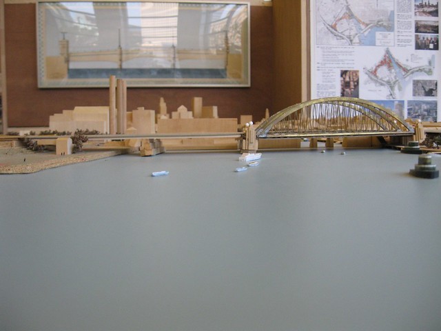
Looking up the Providence River, Iway Bridge at foreground, East Side on right, Jewelry District and Downcity at left.

Fox’s Point where the tug boats currently reside. Shooters would be at the bottom left.

195 land and Corliss Landing on the east side of the river between Wickenden Street and relocated Route 195. Bridge at top is Point Street.

Providence River viewed from the East Side. Early concepts for the west bank riverfront park and Old Harbor District.

Early concepts for Waterplace/Capital Center. Waterplace Basin at center.
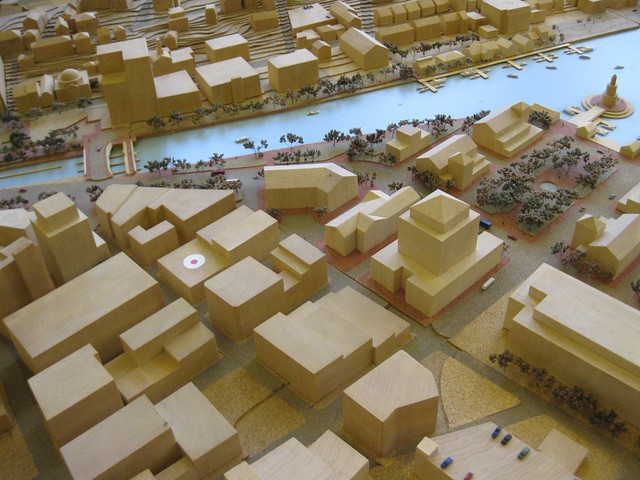
“Parking Lot District” built out. Bridge is Crawford Street. West bank Providence River Park concept at center left.

Looking south across Old Harbor District and Jewelry District. Building at lower right is the Courthouse on Dorrance Street.

Dynamo House at center-left. Bridge is Point Street.

Union Station Plaza with a proposal for twin shiny glass towers.

Union Station Plaza with a proposal for twin shiny glass towers.

Union Station Plaza with final parcel built-out.


Oh, when are we going to get that lighthouse? Ships running aground is such a pressing concern in Providence.
…I hope you can read the sarcasm into this statement. The lighthouse is sooo kitschy.
One fantastical element of this model is the amount of vessel traffic displayed on the Providence River. It would be wonderful to see such active use of the waterway again. Unfortunately, the permanent closure of the Point Street bridge, the low elevations of the pedestrian bridges, and the silting in the river make it all but impossible for the river itself to ever again see the level of activity depicted in the model.
As Providence continues to think about the development of the Shooters site and the future of the port district, it’s worth remembering that one key to a vibrant waterfront is access to the water itself — not just the shore’s edge.
All in good fun.
The lighthouse object could have been just as easily be a small slender tower, which would have provided a balanced counterpoint to the relationship between the Financial District buildings and the waterfront gateway to the city. It’s too bad that the neighborhood is so height phobic and ironic that if such a structure were built, it would be hardly visible from any Fox Point neighborhood house. The city’s southern gateway will likely be created to the west by framing route 95 with a few towers punctuating the landscape, as was suggested at the Knowledge District meeting last September.
@Peter, that’s even sillier, at least a lighthouse is “quaint.”
It’s a nice looking model though. At one point, the city was thinking of funding a model of the city as an attraction, like something a city in China (or Mussolini’s Rome) would do. I’m sure it was forgotten when Cicillini left office, or was at least a victim of the constricted city budget. There was great enthusiasm about it in the RISD architecture department, because presumably the city would prevail on facualty and students to build the thing.
Love the model, with a ziggurat, even! Apparently there was a gym-sized raised-relief/bathymetric model made of Narragansett Bay in the 50s (?) to predict hurricane flooding of coastal areas, but it languished in a warehouse down south somewhere and was finally destroyed. What a shame. Would love to see some pics of that if anyone knows about it.
City models are works of art: http://www.theatlanticcities.com/design/2011/10/the-model-city/280/
I have some photos of the New York model. I used to live in Flushing just a few blocks from the Queens Museum where it is located.
If I recall correctly, there was an older model of Providence at the Natural History Museum in Roger Williams Park back in the 80s. It might have even been the one photographed in Downtown Providence 1970 Plan.
And there was always my favorite: the old scale floor map of Rhode Island at the old Children’s Museum in Pawtucket.