
The Obama administration announced a new round of Transportation Investment Generating Economic Recovery grants (known as TIGER VI) with an extremely short turn-around for submitting applications, they are due April 28th.
The City of Providence applied for a TIGER grant last year, RIDOT also submitted a bid for Apponaug which was supported by the Governor. The Apponaug project was awarded a TIGER grant, and while there isn’t direct competition built into the grant process per-say, it is thought that Providence’s streetcar bid lost out to Kansas City’s streetcar which had more secure funding in place at the time. Providence’s 2013 TIGER grant application included a funding plan, but unlike Kansas City’s successful application, steps had not yet been taken to implement that funding.
Capital costs for the project (costs incurred to build it) are estimated to be $117.8 million (2016 dollars). Funding will come from City TIF Bonds, Federal funds, Rhode Island Capital Plan funds, RIPTA CMAQ funds, and a RIDOT land transfer.
In the next month, Providence plans to work further toward implementation of funding by working with the Providence City Council Ordinance Committee to approve a TIF plan for the streetcar district. This funding represents 50% of the projected cost of the project and will be one of the sources for operations revenue after the project is complete.
Having the TIF plan in place will show readiness for the project which is one of the criteria that is evaluated for the TIGER grant.
[box style=”ltblue”]But what is a TIF?
From the Providence Planning Department:
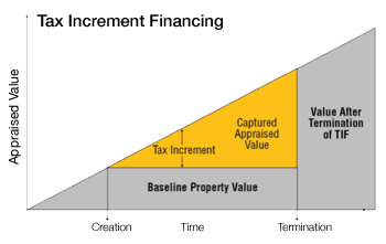 Cities and towns in Rhode Island are authorized to use “Tax Increment Financing” or “TIF” as a tool to generate funding for public improvements in support of economic development (RIGL §45-33.2). TIF’s allow a city to re-invest an increase in property tax dollars coming from an established TIF district back into the neighborhood over a set time period (e.g. 20 years).
TIF revenues are captured as tax revenues rise over time, and DO NOT require an increase in the local tax rate. When a TIF district is established, the City determines the Baseline Property Value (or current appraised value) of all property in the district. Tax revenues from this baseline continue to be directed to the General Fund. Only the increase in tax revenue from within the district and above this baseline is captured by the TIF and reinvested back into the district.
TIF revenues are generated as new development or major renovations take place, and as the value (or “increment”) of taxable property value increases over time. Higher property values may result from: 1) new development on vacant or underutilized land that previously paid minimal taxes; 2) improvements to existing properties, such as a major rehabilitation or additions; or 3) inflation or “natural growth” over time in property values due to reinvestment that is occurring in the neighborhood.
City Council must establish a TIF district, based on a redevelopment plan and project budget which identifies development priorities and defines specific terms. For example, while the chart above shows Baseline Property Value remaining frozen over time, a TIF could be structured to receive only a share of incremental tax revenues – leaving the City’s General Fund to also capture some of the benefits from development in the district.[/alert] [box style=”yellow”]
How will this TIF work?
From the Providence Planning Department:
A new Tax Increment Finance (TIF) District is proposed to support a series of economic development investments including streetscape enhancements, the Providence Streetcar, parking facilities and bike projects.
Analysis performed as part of the Providence Streetcar study in 2012 proposed the TIF district to include the area from Prairie Avenue to College Hill. By making a series of public transit and other investments in this area, it was projected that the total value of taxable property would increase by 44% over a 20 year period. New incremental tax revenues would be over $8.0 million within 3 years, growing to over $30 million after twenty years. These projections conservatively assumed that new development on vacant land would be given a 50% abatement, phased out over 10 years.[/alert]
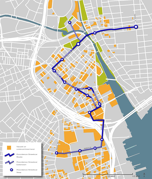
Orange denotes vacant and underutilized land along the proposed streetcar route.
[box style=”orange”]Facts and figures
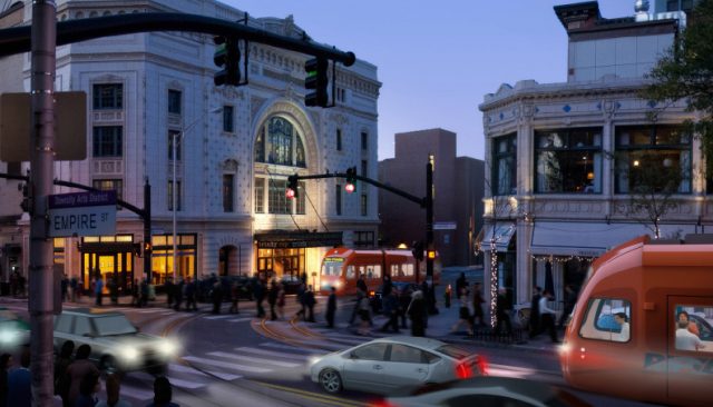
The Streetcar will: spark economic development • create 6,000 new jobs over the next 20 years + 250 construction jobs • increase surrounding property values by $1.1 BILLION • reduce carbon emissions • attract 1,500 new city residents over next 20 years • lower household transportation costs • better connect employment hubs + key attractions
The Streetcar is: a local circulator that will connect College Hill, Capital Center, the Financial District, Downcity, the Hospital District and Upper South Providence
- ROUTE LENGTH – 2.5 miles
- END-TO-END TRAVEL TIME – 15 minutes
- FREQUENCY 12-min (peak) – 15-20 min (off-peak)
- STREETCAR STOPS – 12 stops, approximately every 800 ft
- COST – $117.8 M [2016 dollars] (one-time) $3.13 M (annual)
Streetcar funding:
- 47% City TIF Bonds
- 34% Federal funds
- 13% RI Capital Plan
- 5% RIPTA CMAQ
- 1% RIDOT land transfer
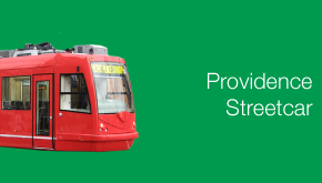
The Providence Streetcar project is also now on Twitter, follow @PVDStreetcar.
[alert type=”success”] Download the Providence Streetcar Summary document[/alert]


12 minute peak time is really not very good. We can’t get 5 minute peak time? 12 minutes is like an off-peak spacing.
This entry prompted me to do some research on the kc street car to better understand the comparisons drawn between these two projects. The kc streetcar seems to earn a lot of praise for connecting several different districts of the city with an efficient and largely linear “trunk line”. Looking at a map of kc, it seems planners emphasized a straightforward and largely direct route between different districts within the city. The Providence streetcar instead of diverts to individual nodes…such as hospitals and train stations in a circuitous manner. Because the vast majority of people who use public transportation are also pedestrians, for these people the real competition for transit comes not from automobiles but their own two feet. The kc streetcar design seems to do an excellent job of augmenting the distance someone can travel in a given amount of time when compared to walking. Its linearity is both easy to understand and is perceived as efficient. In contrast, Unless there is a large concentration of doctors, nurses, and patients who need a shuttle to and from Thayer st…the L shaped nature of the Providence streetcar proposal makes transit a shorter trip on foot.
James, not to seem cynical, but how do you expect a better peak time when the peak time in general of the RIPTA bus system is horrendous. The Streetcar may cover a much smaller area, but when was the last time Public transportation in Providence been world class or even efficient. I hope RIPTA can get their act together.
At current, the proposed Providence streetcar line does not meet the needs of residents or residentially populated neighborhoods including low-income areas (the folks who depend on public transportation the most).
It is more or less a monorail the likes of which can be found in Disney World and ought to be rethought for better access to those populated areas – otherwise, most Providencians will continue to take the bus. What happens when the student populations on the East Side decreases during summer months – there will be even less need.
We need to stop designing Providence around the Ivy League and do whats right for tax payers and residential populations.
Andy, The current plan is only the start. The streetcar will expand to smith street, Westminster towards olneyville , and further south into the south side, which covers most of the lower income areas. There’s a graphic in a PDF on the providence planning website showing where the streetcar will possibly expand to in the future.
On problem is that the decision of what TIGER grants are applied for entails almost no public input, a weakness I intend to note at a public hearing March 27 when the Feds are in town to certify our public participation procedures in transportation planning. They can, and have, suggested improvements.
I brought up the TIGER process Aat the recent Roundtable RIDOT Director Mike Lewis held with environmental groups. He said RIDOT was thinking of applying for funds to get started on the 2 new bus hubs the Governor proposed. I had thought a project needed to be more shovel ready, and suggested if it not that then consideration shoud be given to extending bike paths, either the South County Path to the beach and URI, or the Blackstone to central Woonsocket or even Pawtucket. The latter might help promote a Blackstone Valley Nationl Park and boost the region.
That said, the hub idea seems far superior to the streetcar as it expands access to downtown for transit riders from all directions, reduces strain on Kennedy Plaza without losing its transit function, and much improves bus-train connections. In contrast the streetcar provides no new transit service as that route already has the one-seat Route 1/42 Hope-Eddy line (20 min headways) which give passengers much more flexibility where to get on and off. The lack of a commuter base and RIPTA’s one-state fare of $2 make it difficult to see how its short trip can attract significant ridership. Constructing the streetcar would seriously disrupt all the buses that use the tunnel. The whole idea seems frivolous compared to what else could be done with $115 million or so. The streetcar was mentioned in the state rail plan and drew almost no support, but several said it was a low priorty unless it was to be part of a larger system to serve much more of the region.
Finally, I don’t know what it means for Ripta to “get its act together” as suggested, They have a finite budget, and any service increase on a line must be compensated by a reduction elsewhere. They did recently try to optimize their resources with the recent operations assessment study. In fact, on many lines they do a pretty good job of providing service, often better than most non-users think it is. Those hoping for a better transit might consider not always dissing the current one.
Kansas City isn’t a completely fair comparison. Besides being larger than Providence, KC is a grid city and its downtown and adjacent destinations are more linear. Providence is a radial city for the most part.
Instead of the “L” or “S” shape that’s proposed for the Providence streetcar route, if two shorter linear routes were proposed, one north-south and another east-west, headway times could be significantly reduced than what’s proposed.
There would be a better connection from the train station, which would connect to the hospitals and from the East Side to the West Side. Two routes would make it easier to extend the system to other or less advantaged neighborhoods, such as Olneyville or Lower South Providence/Washington Park, Smith Hill or the North End/Wanskuck, or even affluent Wayland Square.
Two routes would require a KP transfer, which is key to why we have the current design. Besides the single fare issue that Barry raises, for a long time RIPTA has pursued a one-seat one-ride policy. Few can conceive of making transfers. If headways were in the 5-minute range, making a transfer isn’t a big deal, but making a transfer with 12-minute headways is. Because of the streetcar speed, 5- or 7-minute headways would be much faster than walking.
Whether real or perceived, perhaps another reason why the streetcar ended up as a single route might have to do with initial infrastructure cost savings.
Either way, Mark, envision a streetcar going down Chestnut or Richmond Streets. – there is hardly enough room for a single vehicle to pass safely down there now. It would have to be limited to streetcar only traffic. This route is unnecessarily convoluted and benefits only a few. Any surrounding developments would be years, if not decades to come as is now being thought of the former I-195 land. We need to look at the bigger picture.
I wasn’t going to comment on this because I believe it’s already a foregone conclusion that this gets rejected again, as it should be.
I do want to specifically respond to Mark Moreno’s comment that the current plans are “only the start,” however, because you can’t build anything on a broken foundation and that’s precisely what this project is.
As a start to a streetcar network, I’m sorry, frankly, it sucks. It’s not a transit project for transit’s sake, it’s being pushed as a development catalyst. It doesn’t work as a trunk line and never could, it’s only economic saving grace is that it might invalidate plans for a greater amount of cash spent on parking in the Jewelry District, there’s better ridership options that also happen to make much better trunk lines (the R-Line), and there’s more immediate needs that we could be seeking grants for instead – like separating from the MBTA so that Rhode Island’s commuter rail is oriented towards Providence instead of Boston, like the new bus hubs that Barry mentioned, like increasing the frequencies on core routes in Providence, like providing dedicated bus lanes on high-volume streets.
The calculus on this project is bad, because the design is flawed, and it’s fundamentally a product of misplaced priorities. It’s going to be rejected again, as it should be, and my hope is that we’ll finally be able to have an honest conversation about how to plan for a winning streetcar project and a first-class streetcar network in Providence when it is.
Every day we continue chasing the wrong project is one less day that we have to work on getting it right.
The best part is no parking spaces will be harmed in the construction of this streetcar route!
PBN: City set to re-apply for TIGER grant to fund streetcar project
My understanding is the train station spur could consist of one train which simply runs back-and-forth between Kennedy Plaza and the station for this first phase. It could be incorporated into a second line in a future phase.
Ryan, I fear rejection of the streetcar proposal is no sure “foregone conclusion” – in the world of politics with Congressman Cicilline likely to be promoting it, maybe someone in DC seeks to help Tavares. A lot of us thought the successful Apponaug bypass grant request didn’t have much merit, by the way, that includes the Transportation Advisory Committee that once rejected it, it got into the TIP because of an earmark.
Does anyone who lives in Providence know of any public particpation or even Council action in support of the streetcar TIGER application?
Besides bike path extensions, other possible alt transport projects might be the bike/ped bridge on the old I-195 (rejected in the past) or the next step in developing a Pawtucket train station. If you have any thoughts about TIGER priorities I suggest also communicating them to Mike Lewis at RIDOT.
Why such impassioned dislike for this proposal? Providence is at least 20 years overdue for a light rail system, and the proposed starter route is sensible if not perfect, running as it does through the urban core. Why is it “a broken foundation”? Is the infrastructure of the thing so inflexible that routes through high-need areas like Federal Hill and Olneyville could not be easily added in the future? Secondly, does TIGER funding lock a municipality into the original design proposal? Assuming that tweaks can be made once approval is granted, wouldn’t it be wiser to support the application in principle if not to the letter?
There is a symbolic value to permanent mass-transit infrastructure. It sends a message to developers and property owners, not to mention visitors to the city, that Providence is a pedestrian city. It establishes a “spatial code,” so to speak, that is more powerful (because economically driven) than zoning in assuring high-density, mixed-use development.
According to planning documents – the head times are 10-12 minutes. That said it’s going to require five cars on the route during peak. And recall – you can string these together.
But I still maintain the route selected is WRONG. Basically it will tie two well developed economic areas together. But fixed transit should be built to shore up economic progress in downtrodden areas. I say anchor one end in Olneyville and string it up Westminster or Broadway and then to the East Side.
I really wish that planners in Rhode Island, and especially those in Providence, would figure out that there is both a supply and a demand side to parking, and that removing parking from, say, Chestnut Street, is totally okay if it means providing space for a more adequate transit line, since that line will in turn reduce demand for parking. The same for when it’s used for protected bike lanes. I just don’t see why that’s so hard to get for these folks.
The thing that concerns me about this the most is that it prioritizes the mode (rail rather than bus) over the other metrics of success (span, frequency, legibility, etc.). Having frequent service on a route that is easy to understand is more important than having the route be rail. If it’s rail and it does those things too, then all the better, but that’s not the key factor.
I really wish the people planning this would understand that if something is on rails, and somebody decides to double park, or there’s a traffic jam, or if someone’s parallel parking and taking their good time about it, that that slows the streetcar down. There are real problems with rail, and I think they can only be fixed with a right of way, which is really just as simple as declaring certain streets off limits to cars and enforcing that with barriers that the streetcar driver controls.
I think the spur between the train station and Kennedy Plaza sounds like something that won’t have enough ridership in order to be frequent. If it’s not every couple minutes, then it might as well not exist for most people, because the distance is short and can be walked. For the amount of infrastructure that would be needed, I think it would make more sense to add that to the trunk line rather than to divert it somewhere else.
I think we’re forgetting the two main goals of this:
1. High return on investment – projecting 9:1 ratio here
2. Prove success and build upon it – why it’s being proposed for the current route
This is not to come up with a more efficient route from Thayer St to the hospitals or to develop the more downtrodden areas first.
That will all come but we have to start somewhere that will be successful and provide a good ROI.
Sam Coren: I have such impassioned dislike for this proposal, because it’s a farce. The fundamental reason to do this is not and has never been because of ridership metrics – it’s been because there’s huge untapped potential for development in the blighted wastes of the Jewelry District, and because running shiny new streetcars through all of that blight is easier to swallow than a meaningful project like dedicated lanes for the R-Line (but please, won’t somebody think of the parking?!) would be. That’s why everyone backing this thing is MIA on ridership projections but oh so quick to talk about all of that underutilized land just waiting for something to come along and jump-start the economic engine!
Oh, wait, the R-Line already runs within 1/4 mile of most of the routing and would do just as much to jump-start the Jewelry District and doesn’t come at the direct expense of investments to help real people who are really dependent on transit today. We’re “about 20 years overdue” for an overhaul to that route which does more than just make lights in front of the buses stay green longer. The R-Line needs off-board payment and it needs a dedicated lane, and it needed these things 20 years ago. Now that streetcars are experiencing a resurgence as the sexy shiny new travel mode of choice for cities waking up to the need for investment into mass transit, the R-Line is uniquely positioned amongst all of RIPTA’s lines for conversion to a streetcar route.
The existing S-shaped development-maximizing wasteland people mover routing that is the Core Connector circa 2014 cannot and will not work as a trunk line, which is why it is a broken foundation. The route as planned will have serious issues hooking into any future extension down Broadway or Atwells unless the rail infrastructure is replicated just one block north on Empire/Savin, and both the hospitals and the Jewelry District are far better served by a straight line routing down Dyer and Eddy – we have this already in a perfectly serviceable bus route. More offensively still is the fact that where the streetcar is forced into an S-shape trek about the Jewelry district, pedestrians are free to travel in a straight line; and, adding half of the peak frequency (to account for time spent waiting for the trolley to show up) almost every trip “enabled” by the streetcar turns out to be faster on foot. (The only notable exceptions are really traveling from one end all the way to the other.) Similarly, pinning us into a Toonerville Trolley spur between Kennedy Plaza and the train station is worthless and meaningless because of the short distances involved, as James mentioned – but it gets worse, because in the context of the R-Line you can actually serve both on the main trunk without having to introduce spur routes; there’s multiple options for doing so (I’m partial to running along the west side of the station from Exchange onto Gaspee -> Smith -> N Main or with a short bridge over the tracks to connect Gaspee to N Main directly, but those aren’t the only choices here).
And yes, as far as I understand it, winning TIGER funding locks us into pretty much this routing. “Minor changes” like moving the streetcar up one block to solve the Broadway/Atwells issues might be possible, but fundamental changes like switching to a straighter line routing would be impossible. Because of that, I cannot support this project and it would be tremendously unwise to support this project, symbolic value or otherwise. In fact, I want to reiterate what I said before: the symbolic value of this project is a farce. It’s a slap in the face to those who are dependent on the R-Line, because the symbolic value to them is “we don’t care about you, because you don’t have a choice in the matter. So, just deal with it, while we invest elsewhere.”
Ryan,
You really need to take a deep breath and calm down before you post, especially when directing your comment toward another commenter. You post comes across as an attack on Sam Coren which I hope was not your intention.
Jef, it was not my intention for my comment to come off as an attack on Sam Cohen. If that is how it was read, I apologize.
My intention has always been to point out the very real flaws inherent in the streetcar project as designed, which is emphatically the wrong answer for where and how we should invest our capital into mass transit improvements. Pursuing this takes money, effort, and political capital away from far more worthy projects with more immediate merit.
Ridership projections are available on the Core Connector website:
The R-Line in its present from as the combined 11/99 bus sees 10,500 daily riders today according to RIPTA’s R-Line project page, which is a little under four times more than the projected day 1 ridership on the streetcar and about 2.7 times more riders than the most optimistic projection of 2030 ridership. In other words, even if R-Line ridership remains static for the next 16 years it still has about 269% the ridership of the streetcar after 16 years of operation. That’s not good at all – but thank you for grabbing those numbers for me, Jef.
I do want to clarify something that I don’t think I made clear enough in my previous comments. I’m not accusing anyone of holding the opinion that R-Line riders (or the city of Pawtucket) don’t matter. I’m accusing this project of having terrible optics which give off that impression – which doesn’t require that anyone actually hold that opinion, only that it be easy to read into the project and get that impression.
And, indeed, I think it’s tremendously easy to arrive at that conclusion when the project yields terrible ridership projections compared to proven demand and when the actual routing of this project comes close enough to the routing of the proven demand route running today that it may as well be in direct competition. I am going to keep saying it: this is not a good project and it is not the right project.
Ryan: You have studied the maps much more closely than I have and it’s fair to assume that your points about travel times, route quality and the difficulty of expansion are valid.
To zoom out a bit, I support the city’s efforts to get funding for this imperfect proposal because our lack of permanent mass transit infrastructure is THE reason that we are still having the “where are they gonna park?” debate, 54 years after the first downtown master plan which talked about the same problem, in the same way, and offered up the same solutions (more garages). It is exasperating.
As for the argument that any new investment in transit should first benefit the areas with highest ridership like Broad or Atwells, I agree. But I would argue that light rail falls into a different category, and would serve a different purpose–to encourage higher-density urban development in the Jewelry District without the constant and often ineffectual intervention of design committees and the zoning board. And also to confine the development of higher-end residential structures to a well-defined area so that existing neighborhoods are not destabilized.
Sam Cohen: I think we fundamentally disagree on this point. Light rail (and heavy rail, and all other transit – fixed-guideway or otherwise), in my opinion, is meant to serve the needs of people first and property second. Both are important, but it is my belief that the property investment follows the human investment, not the other way around. Indeed, upzoning around transit infrastructure is vital to our continued success as a region.
But I don’t think that capturing investment dollars should ever be the “point” of new infrastructure, as it very much appears to be here. And I think that even if we were to embrace capital return on investment ahead of ridership return on investment, there’s better options for serving the Jewelry District that don’t come packaged with the very real technical flaws inherent in an S-shaped routing – which is the most inefficient shape possible for a vehicle to travel in. Traveling direct down Dyer and Eddy actually serves most of the underutilized land better, creates an opportunity for extension down Allens Ave, doesn’t lock us into the real issues inherent in extending from the current routing to Broadway and/or Atwells, and provides another great option for wiring the train station into the main line instead of as a ridiculous spur over walking distances.
Fundamentally, however, I don’t believe that capturing value should be the priority here. Not when the R-Line on its worst day completely eclipses the best-case-scenario streetcar on ridership and not when we don’t have to choose between the symbolic value of permanent mass transit infrastructure and investing in places where the heaviest mass transit ridership already is. We can have it both ways by providing permanent infrastructure in support of the R-Line, and we can have it both ways by investing in the permanent mass transit infrastructure which already exists in the city in the form of the Northeast Corridor.
We really can’t afford to keep pursuing the streetcar in its current form when there’s at least three better options (the R-Line, a straight-down Dyer/Eddy line, an east-west line between Olneyville and East Providence via Broadway and Brown University, and there’s several others that I’m not mentioning) that should have been on the table a long time ago as the first streetcar line in Providence.
If anything, the Core Connector is a third line to invest in after the north-south trunk line and the east-west trunk line, but even then I don’t think it’s a great option as designed compared to having a trunk line following the R-Line routing and a secondary north-south line along Dyer and Eddy Streets.
I understand your frustration. Believe me, I’m also incredibly frustrated over transit in Rhode Island today – but I don’t think this is merely an “imperfect proposal” that we should support because perfection is the enemy of “good enough.” I believe very strongly that this is a bad proposal, and that supporting it is the wrong move when then are better proposals on the table which could and should be supported instead, and when going forward on this is setting ourselves up for long-term failure.
The world-class mass transit network that Providence will have in 2050 can’t be built out from the Core Connector. It is very much a broken foundation, and it is my earnest hope that we as a region will go back to the drawing board and craft a proposal for a better foundation to Providence’s streetcar network in time for TIGER VII. Every day we waste on the Core Connector as designed is one less day we have for crafting that proposal, which could and would be successful – and far more successful than the Core Connector will probably ever be.
Before everyone gets too exercised about this project and argues whether it’s a good or bad use of resources, let’s take a step back and remember what city we’re talking about. Our city is sadly quite insular, resistant to change, and highly dependent on automobile travel. Providence is notoriously pedestrian-unfriendly, especially as dense northeastern cities go. The downtown/jewelry district core is filled to the brim with parking lots, 45mph roads, and beg buttons. RIPTA bus service does carry people from neighborhood to neighborhood, but from outer neighborhoods to Kennedy plaza (almost exclusively). Aside from the 92, the streetcar would be one of the only (or the only, correct me if I’m wrong) transit route in PVD that starts and ends in places that are not Kennedy Plaza.
If you ask me, anything that would increase the visibility of pedestrianism in Providence (which streetcars are known to do) is a good thing. Perhaps it will (slowly) change the character of downtown providence, from one dominated by cars to one dominated by pedestrians. Perhaps the positive benefits will be much more than just “number of riders” or “square feet of development”. Perhaps the positive benefits can’t be measured in ways that make it into budget bottom lines, but should be taken into account still. Perhaps we need to be a little bit more thoughtful about urban change before we speak so confidently about this or that detail of a transit project.
And do we really have enough faith in the Rhode Island powers that be to believe that there will eventually be a plan we ALL can agree is “good enough”? If so, you’re all much more optimistic than I am, although I might call it naïve.
Andy F, one of the biggest problems is that the RI state government is very Anti-urban and refuses to give RIPTA more money. Money that would make RIPTA more efficient and would reduce peak times of buses. If RIPTA was more efficient, maybe it would increase ridership. I feel like the Rhode Island government just doesn’t care about It’s cities and pro-urban policy in general.
I hear what Andy. F is saying. I think it makes sense for people to split the difference over what can be pushed to be improved, and what is already set. I agree with some of the criticisms about the route, but I think that part of the project is already set and can’t change considerably. What definitely still can change is the degree to which it gets its own right-of-way. Jef said on twitter that as far as the Waterplace Park bridge is going to be exclusive. That’s certainly good news. But the Washington Street portion is not exclusive (KP is up in the air), and the parts in the Jewelry District are not exclusive.
I said in twitter that I think there are things which are politically unrealistic, and things that are physically unrealistic, and that there’s a difference. It’s not to say that politics doesn’t matter or can be discounted, but politics can change, and sometimes quickly. The physical build of a place can’t. We’re not going to get a subway, for instance. It doesn’t matter how we organize or push, what the community thinks or wants, etc. It’s just physically not going to happen. But people can organize and push for the plan to include more segments that are exclusive. With the right education, the community can understand that that will help the project, that it will help all users including cars.
The other piece is the frequency. I think that 12 minutes is really a problem for peak frequency. Who’s taking this? If it’s the first piece of an expanding system, it’s going to be used initially a lot by people just making short trips for errands, etc. People talk about the subway in L.A. having been used to get to lunch at first. But if people have to wait for 12 minutes for a streetcar to come, that makes their trip from one end of the line to the other 26 or 27 minutes, and for a lot of people that’s going to seem too long, especially since the length of the line may not have encouraged them to leave their car at home when they were commuting. So the other piece of this should be pushing the state to match more funding for this so that it can have a decent frequency that’s effective. I don’t know where that money comes from. Existing RIPTA funds? More funds through these (at present, horrible) transportation bills for RIDOT? We should build support for better frequency.
That’s incrementalism, but ambitious incrementalism.
Andy F: The R-Line neither starts nor ends in Kennedy Plaza. RIPTA has also committed to combining the 1/42/77 into a singular route retaining the 1 designation, and that will neither start nor end in Kennedy Plaza. You already mentioned the 92 bus, which I just want to point out is yet another better option for an initial streetcar routing. The 6 bus is being extended to the train station, I don’t know if you want to count that is “neither starting nor ending at KP.”
But – just like there are several better projects on the table if “permanent mass transit infrastructure” is the reason to invest in the streetcar, there are also several better projects on the table worth investing in if the goal is to increase the visibility of pedestrians in Providence and to make the city a better and more walkable place, projects like the bike/ped bridge that Barry mentioned further up the comment chain.
And, if the goal is merely to create more routes which run through Kennedy Plaza instead of starting or ending there – not only are there better projects on the table for doing that, a commitment by RIPTA to couple together more bus routes on opposite sides of Kennedy Plaza as was done with the 1/42/77, the 11/99, and the 26/92 sends a far stronger signal on that front for nearly zero cost.
And, with respect, the argument that it’s going to increase pedestrian visibility doesn’t work here. I’d be far more willing to buy into the argument that it would be a huge win for pedestrianism if the streetcar routing instead went down a heavily trafficked corridor, as the R-Line does. It doesn’t, though. This routing was chosen in strong part to maximize development potential, with ridership return a distant second. The only thing that the streetcar increases the visibility of is a lot of depressed parcels with untapped potential – targets for growth and invitations for new people and new development. Unfortunately, in shining the spotlight on “what could be,” the huge groups of transit-dependent or car-lite people who are here right now and who need something much better than what they’ve got remain invisible.
As I said before, the optics on this are terrible. It sends a very clear message when development concerns are prioritized that the human element is at best a distant second and at worst not worth consideration at all. And like I said before, I don’t believe anyone here actually holds that opinion – but nobody has to hold that opinion for that to be the message received by regular users of the R-Line or car-free residents of Olneyville or anyone else who has been passed by for significant transit investment because the shiny new streetcar as a development catalyst in the Jewelry District was (and still is) seen as more important.
“We don’t care about you” is very much the message this project is sending to those groups of car-lite or car-free residents who are desperate for improved transit in their communities, riders that we can quantify right now and guarantee a Day 1 ridership base very much larger than even the decades-future projections for the streetcar as designed. I think Mark Moreno has nailed it when he accuses state government of being fundamentally anti-urban – this is not an urban proposal. It’s not a transit proposal. It’s an economic development proposal with just enough transit window dressing to go after transit funding sources.
And, I think there is an opportunity to come forward with a project that is “good enough” for everyone to support. Nobody is going to be 100% happy with the project, there’s never going to be the perfect proposal – but there’s a huge difference between perfect and “good enough.” The 92 or the R-Line would be “good enough.” Shifting the route over to Dyer/Eddy would still leave me with a sour taste in my mouth on the ridership angle, but that would also be “good enough” for me to support.. Anything involving Olneyville, especially in light of recent development events down that way, would have been “good enough” for me to support.
This is not a “good enough” proposal. This is not a good project, this is not even a mediocre yet acceptable project. The optics are abysmal, the calculus is horrid, the fundamentals are broken, and the reasons to proceed are all inadequate at best. We should not keep pursuing this.
James: To address your comment briefly, I agree that the route laid out for the project as designed cannot change significantly. That’s why I’m opposing this project – I don’t see a way it can be salvaged or fixed or improved from the standpoint of, as others have suggested, “if we can get secured funding now we can change this project for the better later.”
No, I believe that the only way we’ll ever have a functional and successful streetcar in Providence is if the Core Connector proposal is rejected for the final time, canceled, and dismantled. I want this proposal to fail because as near as I can tell, right now there’s no bad road project to point at and say “well the streetcar failed because a bad road project got money instead” and there’s no competing streetcar or light rail proposal to point at and say “well that city had a better plan, but next time around it will be our turn.” If and when the Core Connector gets rejected for TIGER VI funding, when the dust settles, we will as a region have no other choice but to confront the reality that every single time we’ve lost out on funding for this thing it’s been because the project is bad, and no matter how many rounds of TIGER we submit this thing to, the result will not change.
I eagerly await that day, because that will be the day that we can finally begin the conversation on how to lay out a winning streetcar network for Providence and begin building the strong foundation of a world-class transit network for the region.
Here’s to Incremantalism!
If this project does get funded, then what would the transit advocacy community suggest to improve it, even from those who I have great respect for who absolutely hate the proposal?
ROUTE:
Current negatives are Chestnut and Richmond in the JD with narrow streets that will still be loaded with parked cars; the tortured path that follows Point (always backed up with traffic) to Hospital and Globe; and the dubious Dudley Street extension to Prairie Avenue.
Propose moving the route at Clifford Street south from Chestnut Street to Ship Street then south along Eddy to Globe/Allans Av., where the vehicle service yard is planned. If there’s a spur to the train station, rather than a two-stop route, that train could extend south along the main route and could alternate with the College Hill spur. Both CH and the train station were planned as single track.
EXCLUSIVE RIGHT-OF-WAY:
As proposed the exclusive right-of-way includes the bridge sequence 0.07-miles and the tunnel 0.41-miles, or a total just shy of a half-mile. And yes the tunnel counts.
Propose exclusive right-of-ways at Kennedy Plaza 0.41-miles; Empire Street 0.15-miles; and Eddy Street (between Point and Globe/Allans) 0.15-mile. All of which have enough width for both cars and streetcars, but not parking too! And, will cost less because only one street is dug up instead of two parallel streets in the JD.
HEADWAYS:
Current 12-minutes at peak
Propose 5 to 7-minutes at peak. How? Add one or two train sets, which will add significant salary costs or shorten the route or both. RIPTA has data on headway timing from when they were conducting the study. Eddy at Allans Av is a ¼-mile (5-minute walk) from RI Hospital, Women and Infants is slightly more than a ½-mile (12-minute walk).
EXPANDABILITY:
Currently shown as vague arrows on a map to somewhere.
Insist that the rails be engineered for light rail standards rather than streetcar standards, so that in the future (or soon) the system could accommodate the slightly heavier light-rail train sets that could reach distant city neighborhoods or adjacent cities and towns. Start a study now to determine phasing and locations of system extensions.
To summarize these suggestions, the Core Connector route could be simplified and shortened to 1.8-miles, an exclusive right-of-way could be increased to 0.9-mile, headways could be reduced to 5-7 minutes, but probably at a cost. To insure expandability engineer the tracks so that heavier vehicles could be used.
Three potential downtown street rail routes could be created out of this suggested modified Core Connector plan, all of which can be extended beyond downtown.
1) Eddy Street segment shift in JD could become part of a future northeast-south route to the train station and points south,
2) Washington Street an east-west route linking the East and West Sides
3) Empire/Chestnut/Ship could become a northwest-south route.
Both 1) and 2) allow to West Side access, but also with La Salle Square, which has one of the greatest potentials for high-density development on par with the Financial District. Also, they meet at the Dunk and Convention Center where large numbers of people congregate for events.
R-Line could become a fourth downtown route, if it were shifted to Weybosset in both directions. They will spend about $6-million on the R-Line, which is likely to be highly successful. It probably would be a hard sell to convert the R-Line to rail at this time. Give the Rapid Bus route a chance before conversion. Much political will would need to be gathered to come up with the money for the roughly 8-mile long route. The current proposal for the R-Line corridor in Providence is to upzone to almost triple and eliminate parking requirements for residential. When R-Line ridership doubles, there would be no choice but to convert it to rail.
Olneyville already has great transit service to downtown. Throughout the day a bus leaves the square consistently every 6- or 8-minutes for downtown. With bus stops, it typically takes 11- to 14-minutes to reach KP. A streetcar or light rail vehicle wouldn’t do much better, unless it traveled in a grade separated right-of-way. Street rail to Olneyville could be built in a second phase.
So back to my initial question, not saying that the proposal is good or bad, the best or the worst, What would the transit advocacy community suggest to improve the Core Connector Streetcar proposal, if it gets funded? Any ideas?
I see room for improvement as well, but I also see good opportunities for expansion.
The line that is currently the Thayer St. terminus could be extended westbound on Washington to Knight St. and end at Broadway. This could be a solid east-west core line.
The line that is currently the small Providence Station stub could be extended southbound alonf Exchange, then to Weybosset, then turn onto Dorrance, then to Dyer, then to Eddy, then to Allens. If the the tracks are the same width/gauge, I would LOVE to see this line continue on the Port rail line to the Zoo. Connecting service could be made with the east-west line (as proposed in the previous paragraph) at KP and the line outlined below at the Hess Gas station on Point St.
The remaining “piece” would make a line along it’s existing southern route through the JD but at the intersection of Washington & Empire (where connections could be made with the east-west line) it would continue north on Empire onto Broadway briefly, then to Atwells. Once at Atwells, it could be extended in sections (as money becomes available). First, it could end at Dale St. Then perhaps over the bridge to Eagle Sq. Then further to the west to Valley, etc., etc.
If I had the time (or moreso, the ability) to map it out, I think it would create a very good grid that links a very good mix of neighborhoods, destinations, and purposes that would generat ridership. The connectivity of each of the 3 lines with each other would also create a very nice matrix of inner-city itineraries.
Someone please feel free to photoshop something – I’d love to see it myself.
Peter: If the Core Connector actually gets funded, I’m incredibly dubious as to how much flexibility in the planning we’d actually have from that point forward to go and make changes without jeopardizing our grant (“Well, this isn’t the plan that we awarded funding to and therefore…”)
I am going to act in good faith here and suggest and improvement anyway.
Straightening the route as much as is possible within the confines of needing to serve Brown and the Hospitals probably buys us enough saved mileage to go from 12-minute peak headways to 8-minute peak headways (maybe even 6).
I would actually forget Washington entirely southwest of KP, and turn trains southeast down Dorrance to Eddy Street instead, which is about the straightest we can probably get the route while still serving all of Brown, KP, and the existing service areas. Doing that also means we can avoid having to deal with the problem of going from KP to Broadway until we’re ready to actually run rails down Broadway to Olneyville.
I don’t believe Washington makes a good east-west route. From Washington at Empire, you’re stuck making an S-turn up Empire and then immediately over onto Broadway. If you don’t want to do that, you probably don’t want to make any S-turns, so all of the crossing streets that would have gotten you from Washington to Westminster on the other side of 95 are off the table. That leaves you with Washington to Knight to Broadway (or Atwells) – a little bit too much of a detour for me to be happy with. We don’t have this problem if the streetcar moves up one block to follow Sabin/Empire.
One thing we could do is make the 42 terminate at Thayer Street, instead of going to Kennedy Plaza, and use the time gained from truncating the route to increase the frequency of that route as well. Have the 42 pulse with the streetcar when it comes into Thayer.
ROW is really important and should be as much of the line as possible because it can improve speed and reliability. Speed isn’t that important for speed’s sake alone, but if you take a 15 minute trip and make it a 12 minute one you’ve knocked 20% of the trip time off, and that multiplies more in terms of how frequent the streetcar can be than it does in terms of individual trips (for every fifth streetcar you run, you can add a sixth one for free, since you’re just turning the same rolling stock and driver around, and drivers are paid per hour, not per mile).
I don’t think shortening the route could work. It’s already extremely short. If the route is even up for discussion, I personally think having a straighter route East-West would be better than this L-shaped one, because I think that building off the route in the future would be done best with other through-routes going perpendicularly to it, but I really think pragmatically we should accept the routing itself and just work on what we can in terms of making its frequency and span good.
Ryan, if I can address your concern in terms of this being about development: I think I agree with you more than some that this project unduly focuses on what can be done for real estate rather than ridership, but I wouldn’t go as far as you. I think that development is a key factor in transit growth, and that the two work together. What concerns me most is not whether this is for development per se, but the idea that development comes magically from the existence of rail rather than from the quality of the service. Why do people locate near highways or transit? It’s because either one offers some kind of promise of mobility. Having high quality service is more important than whether the mode is rail or not. We shouldn’t assume that we’ve checked all the necessary boxes of having a shiny streetcar if we don’t have the service up to snuff. That’s the most important part.
I personally think it’s insulting that we can’t get the state to do more to make transit function in Rhode Island, but we’re being told how “progressive’ it supposedly is to relieve people from paying for tolls. :-/ We’ve got to double up on our messaging about that. for sure.
Ryan: I agree that the Sabin/Fountain couplet would be a better choice. In fact, I lobbied for that scheme when RIPTA was determining routes, but it was rejected.
Not including the R-Line, my intent was to use and expand on the current proposal by developing a downtown transit triangle.
The northeast to south or the “East Route” as you suggested, could go from the hospitals to Thayer, but could split to the train station also.
The northwest to south, let’s call it the “West Route,” would continue northbound on Empire to La Salle Square then continue to Atwells/Broadway.
The east-west route or “Cross-town Route” would follow Washington to Winter Street (Hoyle Square) and west to Westminster to Olneyville Square.
My thought on the West Side is that even though Broadway is wider, Westminster has more development opportunity and the West End, parts of which are in rough shape, would benefit more with a streetcar/light rail, and it would better unify Federal Hill and the West End. The bike lane might not survive, if tracks are added to Broadway. Atwells with a high number of residents and tourists who visit, many of whom drive today, would be a built-in ridership. An Atwells alignment could extend to Eagle Square, the north side of Olneyville, and Lower Mount Pleasant to RIC and Mount Pleasant HS and beyond to Fruit Hill in North Providence.
Both the East and West Routes would merge at Eddy and Ship and continue south, where they could split again to Allens Av and Eddy, or if someone really determined to, to Dudley.
The train station route could extend north and northwest, but the deck over the train station platforms would have to be re-built for the streetcar/light rail train weight.
I’m not sure if this would work, but I feel like RIPTA should be privatized because at this point, the way RIPTA is funded, I feel that any capitalist could support RIPTA better than the way the state does now. Also, I feel like the state of Rhode island and the city of Providence refuse to lower property and corporate taxes, which is one very big issue preventing companies to move to RI. The state of RI sure loves debt. The bottom line is that it is cheaper to run a business in Massachusetts than in Rhode Island. Rhode islanders get taxed so high, yet get so little out of what the state uses the tax dollars for.
If property values can be expected to increase ninefold along the streetcar route, TIF is little more than a total giveaway. Why should all this gain stay in a few lucky and or politically wired pockets? A windfall tax would finance transit construction better and faster.
I’ve been thinking about this more. One of the issues is that we have many routes going down Washington, but few going through it. The streetcar would do that for that part of its journey, and to some extent the frequency issues there are partially resolved by those other routes, especially since the 15 trip pass gives free transfers. If the West Side buses run ‘hot’ and we miss them, we’re in trouble because of how unnecessarily spread out the various routes are, but in downtown when a route is late or early there’s often another paring that works (e.g., today we tried taking 27 to pulse with 40, but pulse didn’t work, so we took 42.) The biggest problem here is legibilty. The various routes I can take are all over KP, which isn’t a problem walking-wise, but more in terms of mentally keeping track of where they are not to waste time. Consolidation of routes in the places where we already have effective 5 min. service would help this. Also consolidating so that extensions come from major hubs at the end of the frequent area rather than the middle, so e.g., Olneyville or Thayer being transfer hubs for a very small number of frequent core routes running through KP. All this is just reworking of buses to create legibilty of service. Transfers with high frequency and legibility are fine, just not transfers that make you scratch your head.
But what this leaves is an open question of where the streetcar belongs. I would contend that what we lack is not a route to Brown but a route connecting Statehouse with Jewelry District linearly on a ROW for frequent service. This goes against what I said about the route not being able to be shortened, but if you think about it, the core areas we want development in are effectively branch lines of this proposal. Just like the 40 & 42 go to different endpoints but offer similar downtown to Brown service, the streetcar does the same, with the infrequent endpoint now as the JD. Maybe a shorter, linear route would be a good start since it would amplify its impact in a small area rather than spread it. If we get route legibility on the existing east west routes, they can pulse like a plus sign configuration.
Key thing is linearity, frequency, legibility, and an ROW–and not duplicating service.
I think I disagree with many of the posters on this board on only one simple issue. I don’t believe that sole function of transit is to carry people from one place to another. That’s certainly the proximate function, but it’s one means to a broader set of outcomes related to urban space. Investing in transit moves people around, but it also changes the character of urban places in important ways. Ways that can’t always be quantified or easily overlooked.
And so all this arguing about the specifics of a Providence Streetcar project frustrate me because they seem to start with the unexamined assumption that our only goal should be to move people around. That’s quite insular, and ignores the fact that transit is not separable from other urban functions.
To claim that the streetcar in downtown would not help to bring a more pedestrian-centered culture is shortsighted. It’s a permanent infrastructure change that lets all in downtown know “THIS IS AN AREA FOR PEDESTRIANS”. In many ways, this symbolism is more powerful than direct pedestrian improvements, given its salience. The “shiny new streetcar” might SEEM like a toy, but it’s actually a statement about cementing downtown as a pedestrian space. We can argue about whether that’s true. But don’t just assume it isn’t and move on.
Don’t get me wrong. I also think this could be improved. I would much rather it run from olneyville to the east side. The R-Line is also great. I’d totally be for adding it to a streetcar proposal. But the fact that it’s not added isn’t necessarily a downside. If all we wanted to do was move people from one place to the other, we could use a bus. The streetcar is about broader and indirect change.
Andrew I:
Part of the financing plan to pay for the ongoing operations of the service is a special assessment district for folks who own property near the streetcar to recapture the land-value generation of the project.
Ryan:
A straighter route that bypasses pretty much all of Downcity doesn’t strike you as even less transit-oriented design and even heavier on purely development + Brown to Hospital shuttle?
It’s a shame we don’t have any proper grid so that we could have Matthewson and Richmond act as the primary N-S entrance to the JD which could easily get full ROW. Kinky roads make problems.
I guess the difference IMO is that using the Washington Street path for the eventual full on E-W route and dropping it from the Southern portion of the current track makes sense to me. I’d probably extend the the Southern JD portion up Empire through La Salle and run it along Cedar to Dean St and then to Smith Street.
Maybe that’s a bad idea… seems like a good one to me. Which is why I think Peter is right when he says,
“Currently shown as vague arrows on a map to somewhere.
Insist that the rails be engineered for light rail standards rather than streetcar standards, so that in the future (or soon) the system could accommodate the slightly heavier light-rail train sets that could reach distant city neighborhoods or adjacent cities and towns. Start a study now to determine phasing and locations of system extensions.”
Because I don’t think the current path is a dead-end from a network perspective, just this path as a long term route.
I also agree with Peter on:
“Propose exclusive right-of-ways at Kennedy Plaza 0.41-miles; Empire Street 0.15-miles; and Eddy Street (between Point and Globe/Allans) 0.15-mile. All of which have enough width for both cars and streetcars, but not parking too! And, will cost less because only one street is dug up instead of two parallel streets in the JD.”
I think KP ROW will happen… some of that seems to go up and down as plans get drawn up for what KP will be. Empire can easily be modified for ROW as well.
And I agree that the R-line will get rail, but that’s a VERY expensive project that will prove much easier to get support after the success of that project, which most people feel is all but guaranteed.
Now I don’t like the Dudley to Prairie spur but I was also in meetings with the folks from Upper South Providence who strongly pushed for Prairie to be a part. It was clear they think that’s the corridor that needs service. However, introduces some terrible curves and good R-line and eventually rail down Broad I think meets a lot of that need. I think going the same distance but down Eddy Street where there is also TOD potential is worthwhile and likely can shorten the headways a bit. I’m just not sure that we can afford the cost of an additional car to speed up times and I don’t think a shorter route has a good chance of getting funded.
This is the 38th comment, and I’d like to thank all who participated in this lively discussion, at least some are thinking about how to build first-class transit in this area even if we don’t all agree o every point!
I think Andy is right that transit is about urban development and urban feel as well as moving people and that is a legitmate consideration in evaluating this.
To return to Peter’s question, what should our advocacy community do if this project does get funded? Some suggestions – besides tweaking the starting route as already noted above I’d say encourage a conversation about a more significant system going forward.
However, we will likely have a situation like the Wickford Jct train station/garage with too few riders, thus inhibiting future investments. So we’ll need to think about how to build ridership. These might include:
Instead of Ripta’s 1-state $2 fare, bringing back the old “short zone” to be competitive on such short trips (the short zone once extended for all bus routes between KP and Thayer St, the State House, Davol Square, Classical HS, was abloished when it was 50 cents and the basic fare was $1.25;)
a commitment to transit-oriented tranportation management plans from anyone buying or leasing public property in the I-195 lands;
challenging competing parking policies, for example the legislature is now considering $45 million for a garage at the Garrahy Court House;
promoting the ecopass for private employers in the area to give transit incentives (as Blue Cross does;)
getting URI-Providence to join the Upass (the only public college in the state not to have such a program) instead of just giving everyone “free” expensive parking in the Convention Center garage, and even operating a shuttle from their Shepard building to the garage so nobody would have to walk at all;)
implementing the law requiring a transit incentive to state employees in order to reduce state employee commute vehicle-miles-travelled (ignored so far by Carcieri and Chafee administrations, largely due to state union hostiltiy I’ve been told;)
clear transit directions become part of routine tourism and visitor information.
All that said, I still don’t know what public participation went into this priority for a PVD TIGER application. RIDOT will probably ask for something different, but also likely without public input, (the subject of the upcoming hearing on public participation in transportation planning.)
With all respect to Andrew F., who I generally agree with and think is quite saavy, I think talking about the benefits of any piece of transit w/o ridership, frequency, etc., is magical thinking. What draws people out of their cars and into pedestrian spaces is the usefulness of the service. I hate to be jaded, but unless we’re thinking about that I think we’re ignoring key information. :-/
Jason: It does strike me as even worse on the development-first-people-second front, but I was responding to the question of ‘if this gets approved, what can we do to make it better?’ It’s damage control, in other words.
I’d rather have nothing than have what’s on the table as a proposal, but if we’re going to be forced to live with some iteration of this proposal I’d rather it be an iteration that has the most technical merit (i.e. the straightest route possible) and one that doesn’t pin us into Washington Street as an alignment for the east-west route, which I maintain is sub-par.
“Part of the financing plan to pay for the ongoing operations of the service is a special assessment district for folks who own property near the streetcar to recapture the land-value generation of the project.”
Is there something I do not know of in addition to the TIF scheme? TIF does not capture more of the landowner’s windfall than would the existing property tax.
I’m new to this conversation and Providence, but want to echo Barry by thanking folks for their views. It really has been a great read.
The themes here are important. We can be MUCH more nuanced about our thinking regarding “what transit is for”- I guess I fall more in the fusion category overall. It’s about getting people where they need to go, but the issue here in PVD is that we’re short on concentrated examples of the “where” part, thus the legitimate interest in using transit investments to spur development. It’s clearly a chicken/egg issue. I’m torn on the potential for development, though.
I also have a really hard time understanding why a connection to the train station wasn’t baked in to this originally. I get that there are a limited number of trains per day (now) but if I’m weighing a car-free life, that’s a connection i need. It’s missing pieces like that which suggest to me that they have not given enough consideration to systems planning in conceiving of this project.
More broadly, it seems like this is a project without a base of riders who are transit-dependent, unlike the R line. If people are going to ride it merely to “make short-distance trips between destinations in the downtown area.” So unless they’re residents of downtown, the thinking is they take a bus or drive downtown, then get on? After parking? Obviously that makes no sense, so is this primarily for folks who live downtown? I doubt that’s the plan, but it may be the result.
Somewhat tangentially, I think it’s probably optimistic that the streetcar will make any kind of impactful “statement” about Providence as a Pedestrian City, or change the thinking of auto-centric policy makers. Their parking concerns will never go away, and are usually based in psychology, not reason or economics.
Greg, I don’t think it should be specifically targeted at those who are transit dependent. It should be getting more people to use transit, even if they own a car. A lot of the folks who live on the east side and work in the hospitals don’t drive because it takes forever (have you ever seen traffic on Eddy St at rush hour?). The bus has a stigma associated with it. It’s unfortunate, but true. Rail (whether it’s a streetcar or a train) lacks that stigma (especially when it’s shiny and new).
I honestly don’t think the proposal is too bad. The layout of Providence makes it difficult to not have a line that snakes through and this one doesn’t do a ton of snaking. That said, I’d like to see them give it its own lane so it doesn’t have to ride with automobile traffic.
Greg says, “So unless they’re residents of downtown, the thinking is they take a bus or drive downtown, then get on? After parking? Obviously that makes no sense, so is this primarily for folks who live downtown? I doubt that’s the plan, but it may be the result.”
Yes. Exactly.
I think if someone drove to work and parked, but needed to get across town for lunch or errands, this route might work well *if* it were extremely frequent. I think I said something above in another comment about the L.A. subway and how it was extremely short and set up to grow over time (they’re adding to it now, I think, or least there’s a plan to). People used it to get to lunch, is the joke I’ve heard. But that use is fine, if it starts people off on transit.
Regarding Runaway Jim’s comment that the buses have a stigma, I think that’s true, but I think it can be changed. And I don’t say that to try to nix the streetcar. We should have rail if we can have rail. But I just say it to remind people that rail can get a stigma pretty fast too. Even effective rail. I mean, talk to some folks in the Philly suburbs about taking the El or the Broad Street Line, or any of the trolleys that serve the western streetcar suburbs/West Philly. Rail can very quickly get the same stigma as buses. The reason we don’t have that awareness here is that we don’t have rail. And Boston is also a different city than Philadelphia, or Providence, so the most proximate example of rail is between neighborhoods in Boston that think they’re high-end and expensive. We need to have an awareness that rail is just a tool, and the symbolism of it may seem meaningful, but just like having a green sign or a sharrow on a street does not make that street a bike route, so too does it fall short to have rail that doesn’t have real service.
I’m not predicting that the streetcar will fail utterly. We’ve been growing our base of riders, and the buses we have, however inconvenient, are standing room only at peak times, and relatively full at non-peak times. The streetcar will hopefully have the ability to develop into something better over time. But I do fear that with 12 minute frequency, until it gets to be a longer route, it might have a much lower impact than expected. And I also hope that we start to think about the routing and what we want it to do in terms of connecting things that are unconnected, rather than connecting things that are relatively well-connected. Even the R-Line suggestion seems a little off to me. We need to give that bus a ROW and station payment, not necessarily rail. Rail without a ROW for the 11 or 99 would not give us better service. That project should get focus, but the real question is “What parts of downtown and adjacent neighborhoods are unconnected?” I think the Prairie endpoint makes sense but would suggest pushing for a north-south route to pulse with the existing buses, and then work on legibility of those east-west routes to make that work better.
Runaway Jim,
My point is not that all forms of transit should be focused on transit-dependent folks, but that it’s hard to generate satisfactory ridership without that group.
I’m with James on the stigma issue – yes, it may exist, but IMO it’s as much pro-car as it is anti-bus. Frankly, based in my experience riding the bus in several cities around the country it’s also got some more unpleasant underpinnings, and it seems like that’s the case here as well.
Regardless ofwthe motivation, stigma isn’t a reason to invest 114 million dollars. Rather,, We want to present a clear advantage – to solve problems for people getting around. If it’s hard to get from the east side in a car or bus at rush hour and there’s enough people trying to do it – awesome. Let’s solve their problem. (I’m on the West Side, btw).
I think a big part of the pro-car thing is that it’s more convenient than the bus. The bus is gonna sit in the same traffic as the car, unless it gets its own ROW. The other thing about being pro-car is that Providence is just an easy city to get around in with a car. The traffic here isn’t ridiculous. There’s also plenty of parking almost everywhere you go (unless you’re from Warwick and trying to get somewhere downtown).
I am not saying that reducing stigma of public transportation is a reason for the investment. I’m saying that the streetcar, being shiny and new and connecting the people to where they need to go (the hospitals are the largest employers in the city and a large number of their employees live on the east side). And it is quite difficult to get from the east side to the hospitals at rush hour (and then back again too).
If this is something that can be built upon, let’s put it where the people are and need to go. And the most predictable place for that is east side to hospitals (and Brown Med School in the JD).
All I have to say for my response is 3 letters: BRT
Create a more defined route going west-east of Providence that is like the R-line. Cheaper and it is an easier way for people to understand the transit system. The configuration of the bus routes can currently be difficult for new users to understand and often sways them to just drive or walk. Creating new bus hubs could also decrease the dependence on Kennedy Plaza. That along with a bike share program should help people navigate the city. Providence is so compact that people could walk faster than waiting 12 minutes for the next train. For this plan to have any leverage on getting passed for financial support, that time would have to decrease to 8 minutes. Also, instead of increasing pedestrian traffic, it could actually decrease it. People could take the steetcar from work to their car, instead of walking from their work to the car.
From my time in Providence, I have noticed that the city has arguably the worst roads in the whole country. To think that this city or this state could currently afford to maintain a streetcar at high quality is almost baffling to me. Corporate taxes is the main reason no companies invest in Providence, not because they can’t get from their job to their car.
I just saw that the agenda for the Thursday evening 3/27 TAC meeting now includes presentation of TIGER grant proposals. Note the plural. This means that the public can comment on that topic at the beginning and at the end of the meeting (6:30pm at the DOA building near the State House) as well as perhaps during the official public hearing on transportation planning. This is progress on my point about how the TIGER grant process had previously bypassed public input.
I’ve been a proponent for the streetcar proposal. Besides internal downtown transit, it would act as a catalyst for extensive job creation, population increase, and real estate development, which historically hasn’t happened when just bus service is provided. The success of streetcar/light rail systems similar to this proposal has been repeated in many cities across the country.
At the TAC meeting last night Mark Therrien from RIPTA and Steve Devine from RIDOT jointly presented the Transit Hub proposal for the train station, KP, and the Garrahy courthouse area. The two agencies are working jointly on this proposal and are applying for a TIGER planning grant.
The major focus is on the train station hub to reestablish the rail connection to the city core that was lost when the tracks and station were relocated. Among other illustrations, a highly cohesive conceptual diagram of a north-south and east-west transit ways was shown. The two axes create logical and direct transit corridors for downtown, unlike the proposed streetcar route. Also the transit spines don’t need to be expandable, as they are a composite of the existing bus routes that already extend beyond downtown.
Mark Therrien said, there would be a bus every minute or so along the spines. The New York subway only has that kind of frequency at the peak of rush hour and not on all lines.
So if 1- or 2-minute headways can be achieved on two bus transit-ways, how can the L-shape or S-shape streetcar route with its 12-minute headway times be justified as it’s currently planned?
Could Providence be an exception to the rule regarding the lack of job creation and real estate development, if it only embraces bus transit? Could the successes of Curituba, Brazil and Bogota, Columia be models for Providence?
For those still following this thread, last Thursday evening RIDOT presented their 2 TIGER grant applications:
1 for widening I-95 north from about the Broadway exit to Route 146 as part of the Viaduct peroject, extra cost: about $46 million. Probably take a separate post to explain/discuss this.
2 (with RIPTA) for planning funds for the proposed 2 new downtown RIPTA bus hubs as Peter noted above.
This was just for info, no action of any kind taken. Most responses were positive.
Providence had nobody present to explain the streetcar but they did have a handout. One new thing (for me) were maps of possible future expansions (along Atwells, Westminster, Allens, Smith Hill, Wayland Square) a map of the city’s historic streetcar network, and a US map of cities with proposed streetcar projects (new to me, plans in Boise, Colorado Springs, Spokane, Indianapolis, Columbus, Stamford, Savannah, Miami-Ft Lauderdale and more,…)
I couldn’t make the TAC meeting, but based upon the joint presentation of the transit hub and streetcar support apparently limited to handouts, I’m comfortable in having missed it – maybe I’m reading the atmosphere wrong (more than possible) but I think the silence from both RIPTA and RIDOT representation on the streetcar is deafening.
Per Peter’s comment, I think the presence of a dedicated transitway is more than enough to cancel out the stigma associated with buses. Certainly, if frequencies of 2 minutes or less are actually achievable, then the quality of service would completely blow the streetcar out of the water no matter how much “nicer” streetcars are perceived as being. I’ll confess that I’m skeptical as to whether 2 minutes is achievable when figuring for delays or slow downs outside of the transitway, but I’m optimistic all the same.
As I’ve said before, and as I will maintain, the streetcar as designed is the wrong proposal for Providence and spending the money on literally anything else in the wide world of transit is a better idea in my mind. I’ll need to see more of the transit hub proposal details as it develops, but based on what I’ve heard so far, I think channeling the money and political capital into supporting the train station hub makes far more sense than pursuing the streetcar and I would strongly urge everyone who is similarly skeptical of the streetcar’s benefits to make a point of speaking out in support of the transit hub instead.
Recent Trends in Bus and Rail Ridership by Yonah Freemark
http://www.thetransportpolitic.com/2014/03/03/recent-trends-in-bus-and-rail-ridership/